Situation Summary
Niger remains at elevated structural risk (composite threat score 71, global rank #26) driven by persistent Islamist insurgency, state fragility, and regional military escalation rather than acute crises in the last 48 hours. No firmly corroborated discrete security incidents—attacks, kidnappings, major arrests, or civil unrest—are reported within the last 24–48 hours, though the threat environment across northern and western zones remains volatile. The Alliance of Sahel States (Niger, Mali, Burkina Faso) announced expansion of joint counterterrorism forces to 18,000 troops on July 26, signaling sustained military mobilization and heightened checkpoint activity across border regions. Risk trajectory remains elevated and structurally constrained by weak state capacity, political repression, and recurring cross-border militant activity.
Key Developments
- Alliance of Sahel States Military Expansion, Nationwide (July 26, 2026) – Niger, Mali, and Burkina Faso announced a decision to expand their joint military task force to 18,000 troops to counter Islamist attacks. This signals probable increase in military operations, checkpoints, and potential for clashes in western and border zones, particularly Tillabéri and Agadez regions.
- Diplomatic Tensions with France, Niamey (July 27, 2026) – Niger's government issued a public disapproval statement toward Paris, continuing a pattern of friction over French military presence and influence; no operational security incident reported, but reflects ongoing state fragility and international friction.
- Cross-Border Tensions with Libya, Northern Niger (July 25, 2026) – Niger's military occupied territory along the Libya border, indicating territorial friction and heightened military posture in Agadez region; no active combat reported, but underscores border volatility.
- Regional Arrest/Detention Activity (July 26, 2026) – Multiple detention actions reported involving Nigerien nationals, Nigerian nationals, and a battalion-level unit, with investigations initiated against Nigeria. Pattern suggests ongoing cross-border law-enforcement tension and internal security operations, though specific charges and locations remain unclear.
- Continued Counterinsurgency Operations, Tillabéri Region (Ongoing) – Security forces continue sweep and search operations in Téra area (Tillabéri) following a July 17 militant attack on a Defence and Security Forces detachment (16+ killed, 23 injured); operations remain active but no new incident occurred in the last 48 hours.
Highest-Risk Areas
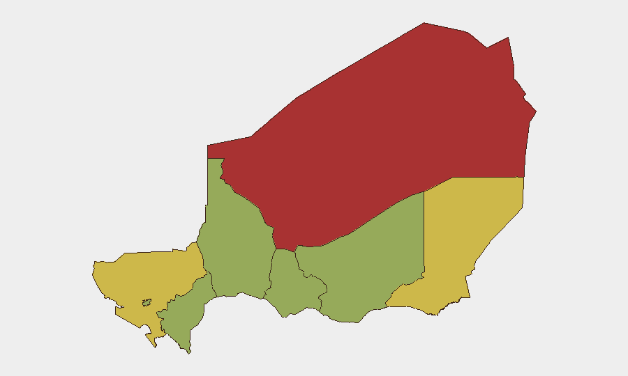
Agadez Region (risk 79.6) and Diffa Region (risk 68.4) drive Niger's overall threat ranking, driven by persistent Islamist militant presence, weak state capacity, and cross-border trafficking networks. Tillabéri Region (65.9) ranks third, reflecting active counterinsurgency operations and recurring attacks on military and civilian targets; western Tillabéri remains particularly dangerous. Niamey itself (54.6) carries elevated urban risk due to state fragility, security-force activity, and sporadic armed clashes. Southern and central regions (Zinder, Tahoua, Dosso, Maradi) remain at elevated baseline risk but currently rank below the northern conflict zones.
How GeoBit Would Assist
Security teams should deploy AOI Monitoring & Early Warning on Agadez, Diffa, and Tillabéri regions to detect militant activity, military operations, and cross-border movements in near real-time. Conflict & Military mapping, force-structure tracking, and network analysis would clarify the disposition and likely operations tempo of expanded Sahel alliance forces and opposing militant cells. OSINT fusion and multi-language intelligence sweeps combined with sentiment and temporal analysis of state media, diplomatic channels, and regional social platforms would provide early warning of political or security escalations before they manifest in kinetic activity.
7-Day Outlook
Military operations in western and northern Niger are likely to increase in tempo and geographic scope as the Sahel alliance forces expand and redeploy. Checkpoint density and movement restrictions in border zones (Tillabéri, Agadez) should be expected to rise, affecting supply chains and travel. Risk of secondary militant attacks in response to expanded military pressure remains elevated but is not expected to produce a specific crisis in the next 7 days absent a major tactical shift.
Highest-Risk Areas — Ranked
| # | State / Region | Risk |
|---|---|---|
| 1 | Agadez Region | 79.6 |
| 2 | Diffa Region | 68.4 |
| 3 | Tillabéri Region | 65.9 |
| 4 | Niamey | 54.6 |
| 5 | Zinder Region | 49.6 |
| 6 | Tahoua Region | 49.6 |
| 7 | Dosso Region | 49.6 |
| 8 | Maradi Region | 49.6 |
Sources
Previous Daily Briefs
A new Niger brief is written every day — each with its own risk map and downloadable CSV. Here's the last week; use the calendar to go further back.
📅 Browse every day by calendar →
Highlighted days have a brief. Tap a day for that day's map & analysis, or “csv” for that day's dataset ($5).
Atlas — our AI intelligence desk — emails them this snapshot personally. Nothing else, no list.