Situation Summary
Niger remains a complex operating environment with a composite threat score of 67 (rank #25 globally), driven by persistent insurgent activity, political tensions, and governance instability rather than acute crisis events in the immediate reporting period. Open-source monitoring over the last 24–48 hours has identified no new discrete security incidents, attacks, or civil unrest; the threat environment remains characterized by structural risks and ongoing extremist pressure in the north and east. The Sahel Alliance's recent (26 July) announcement to expand joint counter-insurgency forces to 18,000 troops reflects sustained defensive posturing but no imminent escalation indicators in the last two days.
Key Developments
No corroborated discrete security, conflict, or civil-unrest incidents have been reported in Niger within the last 24–48 hours according to open-source security bulletins and news monitoring. Threat activity remains consistent with longer-term patterns: sustained jihadist pressure in Diffa and Tillabéri regions, cross-border tensions with neighboring states, and political restrictions domestically. Teams should monitor for incident signals in the monitored event feed (most recent being a 28 July company threat and 27 July junta-related commentary), but these have not yet crystallized into reportable discrete events with confirmed locations or casualty data. Absence of reported incidents does not indicate reduced threat; rather, the security environment remains at elevated baseline risk, particularly in border zones.
Highest-Risk Areas
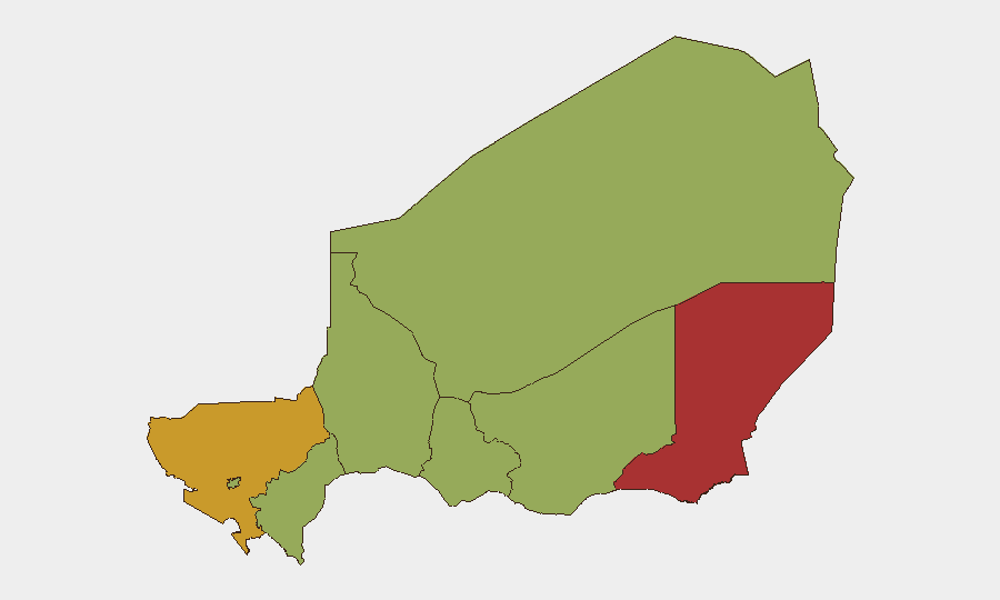
Diffa Region (76.9) and Tillabéri Region (72.9) dominate the threat landscape, both experiencing persistent jihadist and criminal activity linked to ISIL-affiliated and al-Qaeda-aligned groups operating across the Niger–Nigeria and Niger–Mali borders respectively. Diffa's elevated score reflects ongoing kidnappings, supply-line attacks, and recruitment pressure; Tillabéri combines border instability, military engagement, and spillover from Mali's deteriorating security situation. Niamey (54.9), while significantly lower-risk than border zones, faces governance-related tensions, detention activity, and political friction with international actors—reflected in recent arrest/investigate signals. Remaining regions (Agadez, Zinder, Tahoua, Dosso, Maradi) all carry moderate baseline risk (46.9–48.9) from infiltration, smuggling, and intermittent militant activity, but do not currently show acute incident clustering.
How GeoBit Would Assist
Corporate security teams should employ AOI Monitoring & Early Warning to maintain persistent watch over Diffa and Tillabéri, with alerting rules tuned to jihadist tactical signatures, military movements, and cross-border incursions. Intel Sweep and multi-language OSINT (X, Telegram, YouTube, regional media) provide early detection of emerging threats, group statements, and casualty reports hours before traditional news outlets. Conflict & Military tracking (force structure, weapons capability, battle mapping) allows teams to contextualize reports of military operations and garrison strength, critical for duty-of-care assessments in or near operational zones. Routing & Network Analysis supports alternative-route planning and journey security for personnel transiting high-risk regions.
7-Day Outlook
Threat trajectory remains stable at elevated baseline, with no indicators of imminent major escalation or significant de-escalation. Seasonal factors (harvest, population movement) and political calendar (junta consolidation efforts) will continue to shape militant recruitment and operational tempo. Teams should anticipate continued low-level cross-border activity and maintain heightened vigilance around Niamey's political environment and northern supply corridors.
Highest-Risk Areas — Ranked
| # | State / Region | Risk |
|---|---|---|
| 1 | Diffa Region | 76.9 |
| 2 | Tillabéri Region | 72.9 |
| 3 | Niamey | 54.9 |
| 4 | Agadez Region | 48.9 |
| 5 | Zinder Region | 46.9 |
| 6 | Tahoua Region | 46.9 |
| 7 | Dosso Region | 46.9 |
| 8 | Maradi Region | 46.9 |
Sources
Previous Daily Briefs
A new Niger brief is written every day — each with its own risk map and downloadable CSV. Here's the last week; use the calendar to go further back.
📅 Browse every day by calendar →
Highlighted days have a brief. Tap a day for that day's map & analysis, or “csv” for that day's dataset ($5).
Atlas — our AI intelligence desk — emails them this snapshot personally. Nothing else, no list.