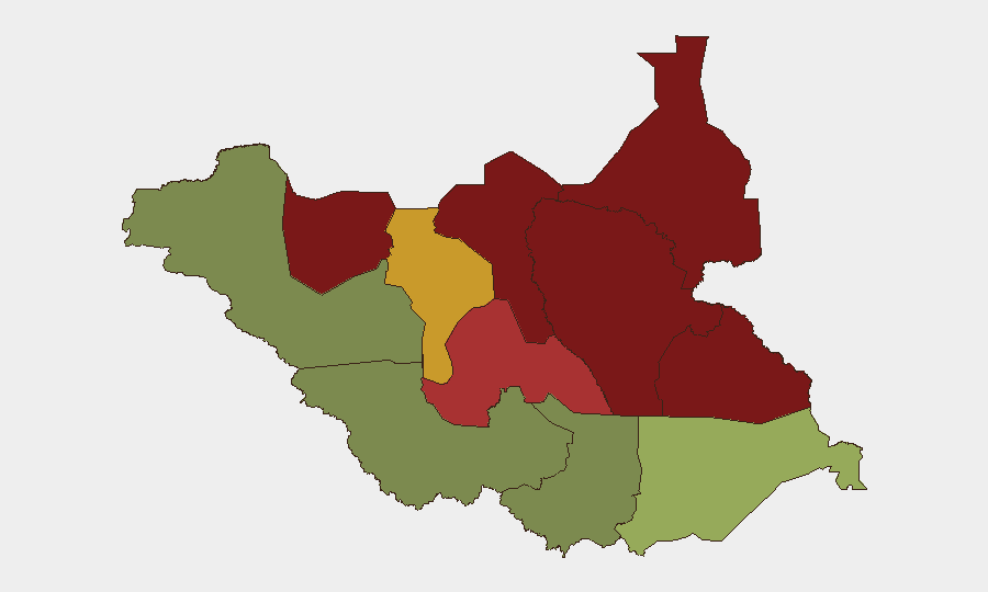
Situation Summary
South Sudan remains at elevated civil-unrest risk (composite threat score 65, rank #31 globally), with no significant new incidents reported in the last 24–48 hours (31 August–1 September 2026). However, the security environment was marked by high-impact violence in late August—including a fatal UNMISS convoy ambush in Jonglei (24 August) and a large-scale cattle raid in Warrap (27 August)—that has amplified transport and operational risk across northern and central regions. Political tension between President Kiir and Vice President de Mabior, reported on 31 August, adds uncertainty ahead of December elections but has not yet translated to documented civil unrest or protest activity.
Key Developments
- No major violent incidents confirmed for 31 August–1 September 2026. Available reporting does not show corroborated new attacks, protests, or security events in the specified window.
- Political confrontation noted 31 August (Juba, national scope). Media documented public friction between President Salva Kiir and Vice President Rebecca Nyandeng de Mabior; impact on transitional-government cohesion and electoral preparations (scheduled December 2026) remains unclear, with no associated unrest documented as of 1 September.
- Late-August violence continues to shape operational risk. The 24 August UNMISS ambush near Pajut (Jonglei) and 27 August Machar-Pakuek/Mading Juer cattle raid (Warrap) remain active concerns for transport corridors and UN force-protection operations.
Highest-Risk Areas
Unity, Jonglei, Upper Nile, and Greater Pibor Administrative Area dominate the sub-national ranking (scores 95, 93, 88, 87 respectively), driven by persistent armed raiding, inter-communal cattle conflict, and weak state control. The 27 August Warrap incident—killing 49 civilians in a cross-border criminal network raid—reflects how pastoral-belt states (Warrap, Lakes, Northern Bahr el Ghazal) remain vulnerable to organized violence even when ranked below the far north. Central Equatoria and Western Equatoria present significantly lower risk (35 and 38), making the capital region and southwestern approaches relatively more stable for operations and movement.
How GeoBit Would Assist
Corporate security teams operating in South Sudan should prioritize Intel Sweep and global event feeds for real-time incident detection across high-risk northern states, combined with multi-language OSINT and X/Twitter/Telegram monitoring to capture early signals of inter-communal tensions and armed-group movements. AOI Monitoring & Early Warning on Unity, Jonglei, and Warrap—with persistent watch on transport corridors and UN installations—would provide alerting before incidents escalate. Routing & Network Analysis enables security teams to identify and pre-stage alternative routes around Pajut, Tonj North, and other recent flashpoints, while sentiment & temporal analysis on political figures and electoral rhetoric flags downstream risk to stability ahead of December elections.
7-Day Outlook
No imminent escalation is evident in the 24–48 hour window, but the late-August violence cluster and political-elite friction create conditions for renewed unrest. Risk to transport, pastoral areas, and UN operations remains elevated; electoral positioning may generate secondary tensions by mid-September. Security teams should maintain heightened vigilance on Jonglei, Warrap, and Unity while monitoring political developments in Juba for signs of transitional-government fracture.
Highest-Risk Areas — Ranked
| # | State / Region | Risk |
|---|---|---|
| 1 | Unity | 95 |
| 2 | Jonglei | 93 |
| 3 | Upper Nile | 88 |
| 4 | Greater Pibor Administrative Area | 87 |
| 5 | Northern Bahr el Ghazal | 82 |
| 6 | Lakes | 78 |
| 7 | Warrap | 72 |
| 8 | Ruweng Administrative Area | 68 |
| 9 | Eastern Equatoria | 52 |
| 10 | Western Equatoria | 38 |
| 11 | Central Equatoria | 35 |
| 12 | Western Bahr el Ghazal State | 28 |
Sources
Previous Daily Briefs
A new South Sudan brief is written every day — each with its own risk map and downloadable CSV. Here's the last week; use the calendar to go further back.
- August 30, 2026
- August 28, 2026
- August 26, 2026
- August 24, 2026
- August 22, 2026
- August 20, 2026
- August 18, 2026
📅 Browse every day by calendar →
Highlighted days have a brief. Tap a day for that day's map & analysis, or “csv” for that day's dataset ($5).
Atlas — our AI intelligence desk — emails them this snapshot personally. Nothing else, no list.