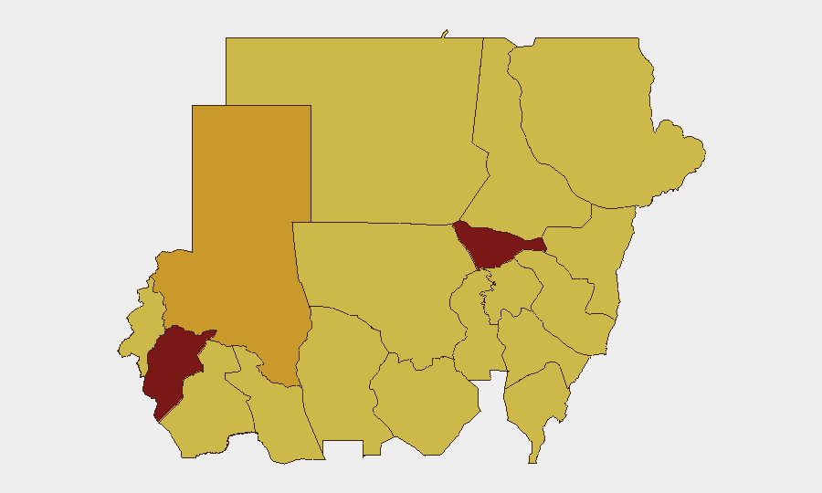
Situation Summary
Sudan remains the second-highest global threat environment (composite score 98), driven by ongoing civil war between the Sudanese Armed Forces (SAF) and Rapid Support Forces (RSF) spanning 25 tracked events. Open-source reporting from the past 24–48 hours remains sparse; however, signals from 30 July–1 August indicate continued military operations, diplomatic friction (notably with the United States and South Sudan), and domestic political pressure. The conflict continues to fragment state control, enabling secondary criminal and humanitarian risks across major urban centers and supply corridors.
Key Developments
- Al Sadarat highway, North Kordofan State (26–27 July 2026): SAF announced recapture of the strategic Khartoum–El Obeid corridor following two days of heavy combat, retaking Um Qurfa, Jarigakh, and multiple towns. This signals resumption of military logistics control but heightens civilian exposure along the route.
- North Kordofan operations (late July 2026): SAF reported recapture of five additional strategic areas (Um Sayala, Bara, Jabra Al-Sheikh, Um Qirfa, Jarejkh) in the Omdurman–El Obeid export corridor, corroborating highway-control claims and indicating sustained high-intensity combat.
- El Obeid bombardment (late July 2026): RSF drone strikes and artillery bombardment on El Obeid infrastructure and civilian areas reported over several days, including power-transformer damage causing localized blackouts; pattern suggests ongoing daily targeting.
- Diplomatic signals (30 July–1 August 2026): Military issued public statements and threats; Congress rejected action; Saudi Arabia and the United States issued public statements toward Sudan; South Sudan expressed disapproval. These signals suggest diplomatic escalation alongside military operations.
- Southern Omdurman crime spike (late July 2026): Armed home invasions, robberies at gunpoint, and at least two deaths reported in Al-Salha area, reflecting criminal exploitation of security vacuum in the capital's periphery.
- Rabak gang violence (late July 2026): Nighttime armed attacks and home robberies reported, including one confirmed fatality (Bahaa el-Din Mohamed, age 30), signaling elevated criminal risk during hours of darkness.
- Port Sudan heat emergency (late July 2026): Extreme heatwave affecting ~1 million residents, with health warnings for children and outdoor workers; concurrent power-infrastructure strain (thermal barge imported to Red Sea State) indicates compounding civilian risk.
- Media freedom pressure (late July 2026): Cybercrimes Prosecution in Red Sea State issued arrest warrants for 47 journalists, signaling heightened political repression and rights risk.
Highest-Risk Areas
Al Khartum (98.4) dominates the risk ranking, driven by direct SAF–RSF competition for control, urban crime, and critical infrastructure vulnerability. Central Darfur State (82.8), North Darfur State (71.7), and the Blue Nile/Aj Jazira corridor (68.4 each) reflect sustained conflict, displacement risk, and humanitarian strain. Red Sea State ranks equally (68.4) but for distinct drivers: heat/health emergency, power shortages, and media repression. The clustering of eight states at 68.4 indicates widespread secondary instability—criminal violence, supply-route disruption, and gang activity—beyond the primary conflict zone.
How GeoBit Would Assist
Corporate security teams should deploy AOI Monitoring & Early Warning on Al Khartum, El Obeid, and Rabak to detect shifts in SAF–RSF positioning, drone-strike frequency, and urban-crime patterns in real time. Routing & Network Analysis and Conflict & Military force-structure tracking enable duty-of-care teams to identify safe corridors and alternative logistics routes as battlefield control shifts. Intel Sweep (X/Twitter OSINT, multi-language sources, and sentiment analysis) closes the gap between official claims and ground reality, reducing blind spots in 24–48h reporting windows typical in conflict zones.
7-Day Outlook
SAF gains in North Kordofan may ease supply pressure but will likely trigger RSF countermeasures (drone strikes, harassment of logistics lines). Urban crime in Khartoum and secondary cities will persist as the security vacuum deepens. Diplomatic friction and media crackdowns suggest internal regime stress; continued military operations, not resolution, remain the baseline trajectory.
Highest-Risk Areas — Ranked
| # | State / Region | Risk |
|---|---|---|
| 1 | Al Khartum | 98.4 |
| 2 | Central Darfur State | 82.8 |
| 3 | North Darfur State | 71.7 |
| 4 | Blue Nile | 68.4 |
| 5 | River Nile State | 68.4 |
| 6 | Aj Jazira | 68.4 |
| 7 | Red Sea State | 68.4 |
| 8 | Al Qadarif State | 68.4 |
| 9 | Kassala State | 68.4 |
| 10 | Sennar State | 68.4 |
| 11 | South Darfur State | 68.4 |
| 12 | West Kurdufan State | 68.4 |
Sources
Previous Daily Briefs
A new Sudan brief is written every day — each with its own risk map and downloadable CSV. Here's the last week; use the calendar to go further back.
📅 Browse every day by calendar →
Highlighted days have a brief. Tap a day for that day's map & analysis, or “csv” for that day's dataset ($5).
Atlas — our AI intelligence desk — emails them this snapshot personally. Nothing else, no list.