Situation Summary
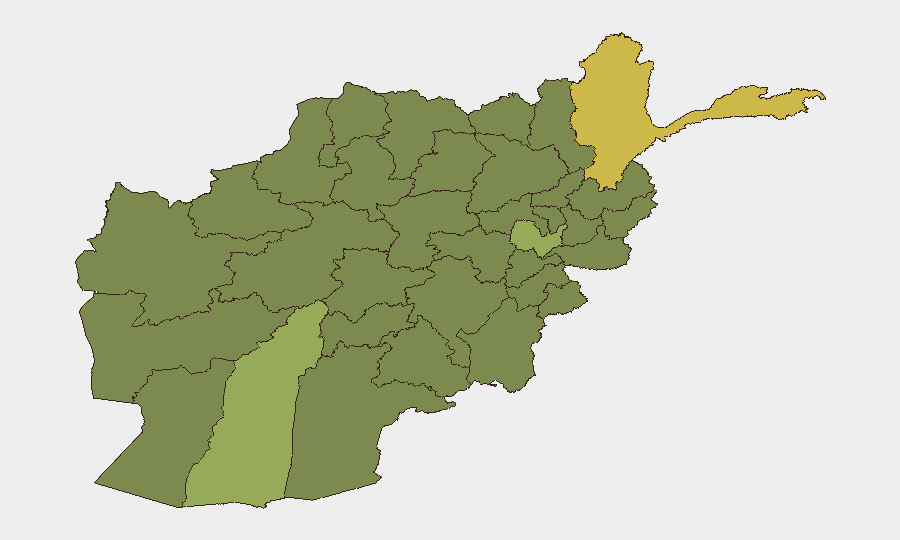
Afghanistan remains at composite threat rank #33 globally with 32 tracked events, driven primarily by escalating armed resistance operations in the northeastern provinces against Taliban control. Badakhshan Province has emerged as the highest-risk jurisdiction (69.9), with heavy clashes between Taliban forces and the Afghanistan Freedom Front (AFF) now in their third consecutive day as of 29 July. The conflict is spreading across multiple northeastern provinces and along key transit corridors, creating acute risk for personnel and asset movement. Trajectory indicates sustained or intensifying resistance activity through early August.
Key Developments
- Zebak district, Badakhshan (29 July): Heavy clashes between Taliban and AFF continue for third day. AFF claims 21 Taliban killed and 37 wounded; Taliban reports positions shelled and overrun. Two Taliban military drones reportedly shot down near frontlines, degrading Taliban ISR capability.
- Zebak approaches, Badakhshan (29 July): Taliban has planted landmines on routes leading to checkpoints following multi-day clashes, significantly increasing IED risk for any ground movement in the district.
- Doshi district, Baghlan (29 July): AFF ambushed Taliban reinforcement convoy moving along Kabul–Badakhshan axis (Salang corridor). AFF claims seven Taliban killed, six wounded; unit reportedly withdrew without losses. Independent casualty verification unavailable.
- Andarab district, Baghlan (28–29 July): Rocket attack on Taliban checkpoint followed by several hours of fighting. No confirmed casualty figures; independent damage assessment pending.
- Multi-district fighting, Badakhshan (28–29 July): Clashes reported across Zebak, Yaftal, and Darayem districts simultaneously. Multiple local sources confirm ongoing insecurity and intermittent gunfire overnight despite contradictory claims on battlefield control.
- Northeastern corridor risk (28–29 July): Resistance operations spreading across Badakhshan and Baghlan provinces with coordinated AFF operations and movement of reinforcements by both sides, elevating travel and operational hazard on regional highways.
Highest-Risk Areas
Badakhshan Province (69.9) dominates the risk profile due to active multi-day conventional military clashes, IED deployment, and confirmed drone operations by both sides. Helmand (56.4) and Kabul (53.8) represent secondary concentrations of risk, while a cluster of southern and eastern provinces (Zabul, Kandahar, Ghazni, Paktika, Farah, Nimruz) and northern provinces (Jowzjan, Balkh, Badghis) register at 39.9, likely reflecting lower-intensity but persistent Taliban-opposition friction and sporadic militant activity. The northeastern escalation is driving overall national risk upward and poses direct threat to the Kabul–Badakhshan transit corridor critical for supply and personnel movement.
How GeoBit Would Assist
Security teams should deploy AOI Monitoring & Early Warning on Badakhshan, Baghlan, and key transit corridors (Salang highway, Doshi–Zebak access routes) to track daily clashes and casualty reports with real-time alerting. Routing & Network Analysis would identify safer alternative routes around active conflict zones and IED-planted approaches. Battle Mapping and Conflict Intelligence (using multi-language OSINT, entity extraction, and sentiment analysis across regional media and resistance channels) would enable continuous verification of casualty claims and force positioning, reducing reliance on unconfirmed AFF and Taliban statements.
7-Day Outlook
Resistance momentum in the northeast is likely to sustain through early August absent major Taliban reinforcement or tactical shift. Ground movement in Badakhshan, particularly in Zebak and along the Salang corridor, carries acute risk from both active clashes and newly deployed mines. Personnel and supply chains dependent on northern routes should anticipate further disruption and route diversions.
Highest-Risk Areas — Ranked
| # | State / Region | Risk |
|---|---|---|
| 1 | Badakhshan Province | 69.9 |
| 2 | Helmand Province | 56.4 |
| 3 | Kabul Province | 53.8 |
| 4 | Zabul Province | 39.9 |
| 5 | Kandahar Province | 39.9 |
| 6 | Ghazni Province | 39.9 |
| 7 | Paktika Province | 39.9 |
| 8 | Farah Province | 39.9 |
| 9 | Nimruz Province | 39.9 |
| 10 | Jowzjan Province | 39.9 |
| 11 | Balkh Province | 39.9 |
| 12 | Badghis Province | 39.9 |
Sources
Previous Daily Briefs
A new Afghanistan brief is written every day — each with its own risk map and downloadable CSV. Here's the last week; use the calendar to go further back.
📅 Browse every day by calendar →
Highlighted days have a brief. Tap a day for that day's map & analysis, or “csv” for that day's dataset ($5).
Atlas — our AI intelligence desk — emails them this snapshot personally. Nothing else, no list.