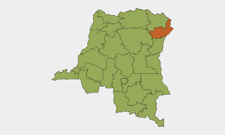
Situation Summary
DR Congo remains at elevated civil-conflict risk (global rank #20, composite score 68), driven by ongoing fighting between AFC/M23 forces and the Congolese army across North and South Kivu, combined with ADF militant activity in Ituri. The past 72 hours have seen civilian casualties from ADF attacks in Maniema/Ituri and continued clashes between armed groups and national forces across eastern provinces, with no indication of de-escalation. Arbitrary detention, targeted killings, and displacement continue to characterize the operating environment.
Key Developments
- Mambasa territory, Ituri (23–26 July): ADF militants killed at least 32 civilians in two village attacks over a 72-hour period, triggering fresh displacement to neighboring communities and reinforcing the threat to civilian populations in the region.
- Kalembe and Kalonge, Nord-Kivu (night of 23–24 July): Violent clashes between AFC/M23 forces and Wazalendo militias were followed by a reported "precarious calm," indicating fragile local stability and ongoing risk of renewed fighting that could disrupt movement and supply lines.
- Luhwinja, Sud-Kivu (around 24 July): The administrative secretary of Luhwinja chiefdom was shot dead by armed men in an AFC/M23-controlled area, highlighting targeted elimination of local leaders and insecurity in rural Sud-Kivu.
- Goma, Nord-Kivu (around 24 July): AFC/M23 forces detained approximately 50 youths near Katindo camp, raising concerns about arbitrary arrest, forced recruitment, and potential abuse near military installations in the provincial capital.
- Hauts Plateaux, Sud-Kivu (mid–late July): Ongoing combat between AFC/M23 and the Congolese army continues in the South Kivu highlands; the UN High Commissioner for Human Rights publicly noted persistent fighting and civilian impact within the last 48 hours.
- Eastern border zone, Ituri/Nord-Kivu (23–25 July): Low-level but persistent FARDC vs. non-state armed group engagement reported, with chronic militia activity in North Kivu, elevating threat to road movement and humanitarian operations.
Highest-Risk Areas
Ituri province (risk 74.9) remains the critical hotspot, driven by sustained ADF militant activity and intercommunal violence. North and South Kivu (both 44.9) are secondary focal points, where AFC/M23 operations, clashes with FARDC, and local militia activity create a fluid, fragmented threat environment. The remaining northern and central provinces (Maniema, Équateur, Mongala, Tshopo, and others, all 44.9) reflect diffuse governance collapse, armed-group presence, and limited state control rather than single large conflict fronts, elevating risk for movement, supply-chain disruption, and staff safety across wide areas.
How GeoBit Would Assist
Security teams operating in DR Congo should deploy AOI Monitoring & Early Warning for Ituri, North Kivu, and South Kivu to receive real-time alerts on clashes, detention sweeps, and displacement events. Conflict & Military (force structure and battle mapping) and Network & Actor Analysis (tracking AFC/M23, ADF, and militia command) provide situational awareness of armed actors and their movements. Routing & Network Analysis enables alternative-route planning to circumvent active fighting zones and roadblocks, while OSINT fusion (multi-language, X/Twitter, local media) supplies rapid corroboration of incidents when official channels are silent.
7-Day Outlook
No major ceasefire or territorial shift is anticipated in the next week. Clashes are likely to remain low-to-moderate intensity across Nord-Kivu, Sud-Kivu, and Ituri, with periodic spikes in localized violence and civilian impact. Road security will remain volatile; humanitarian and commercial operations should assume extended transit delays and intermittent access restrictions.
Highest-Risk Areas — Ranked
| # | State / Region | Risk |
|---|---|---|
| 1 | Ituri | 74.9 |
| 2 | Maniema | 44.9 |
| 3 | Sud-Ubangi | 44.9 |
| 4 | Équateur | 44.9 |
| 5 | Nord-Ubangi | 44.9 |
| 6 | Mongala | 44.9 |
| 7 | Lower Uele | 44.9 |
| 8 | Tshopo | 44.9 |
| 9 | Tshuapa | 44.9 |
| 10 | Upper Uele | 44.9 |
| 11 | North Kivu | 44.9 |
| 12 | Lualaba | 44.9 |
Sources
Previous Daily Briefs
A new DR Congo brief is written every day — each with its own risk map and downloadable CSV. Here's the last week; use the calendar to go further back.
📅 Browse every day by calendar →
Highlighted days have a brief. Tap a day for that day's map & analysis, or “csv” for that day's dataset ($5).
Atlas — our AI intelligence desk — emails them this snapshot personally. Nothing else, no list.