Situation Summary
Iran faces sustained conventional military strikes from US Central Command, now in their tenth consecutive night, targeting transport infrastructure, military installations, and urban areas across southern and central provinces. Confirmed civilian casualties (8–9 deaths, multiple injuries) have been reported in Hormozgan Province, and strikes have expanded geographically to include central provinces (Markazi, Semnan). The conflict trajectory remains active and multi-domain, with no ceasefire signals and widespread infrastructure disruption across high-risk southern regions.
Key Developments
- Bandar Abbas, Shiraz, Sirik, Khomein (Jul 20, evening local time): US Central Command confirmed the tenth consecutive night of airstrikes; Iranian media reported explosions in Bandar Abbas and Sirik (Hormozgan), plus Khomein (central Iran), striking military and infrastructure targets.
- Bandar Abbas–Kahoorstan–Lar Road, Hormozgan (Jul 20, local time): Traffic suspended following reported US strike on Shoor River Bridge; transport corridor remains compromised and travel risk elevated.
- Hormozgan Province bridges and airport (Jul 19, early morning local time): US strikes reported on two bridges, an airport, and a railway station; three confirmed dead, nine wounded from bridge attacks alone.
- Multiple southern cities—Lar, Ahvaz, Yazd, Bushehr, Bandar Abbas, Qeshm Island (Jul 19–20 night, local time): Live conflict mapping recorded bombing on airports, bridges, communications towers, and residential areas across multiple provinces; eight civilian deaths reported in Hormozgan, including women and disabled civilians.
- Khandab city and Semnan Airport (Jul 19–20 night, local time): Projectile strikes attributed to US operations expand strike footprint northward into central and northern transport/aviation infrastructure.
- Hormozgan Province—ongoing (since Jul 19): Ten consecutive nights of strikes create sustained risk to port operations, power infrastructure, and urban services in Bandar Abbas and surrounding areas.
Highest-Risk Areas
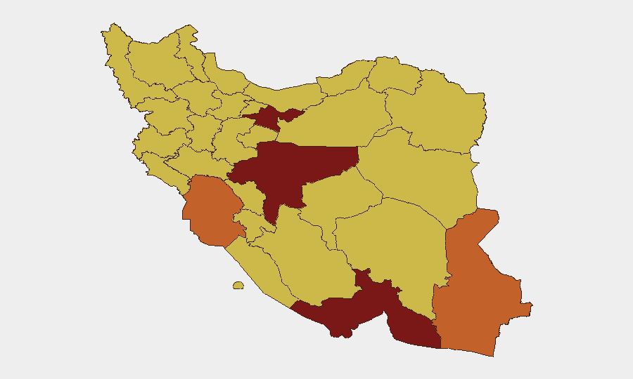
Tehran Province (96.5), Isfahan (88.3), and Hormozgan (82.2) drive the composite threat ranking. Hormozgan is the immediate operational focus—confirmed strike sites, transport infrastructure damage, civilian casualties, and port/maritime chokepoint exposure elevate risk for any personnel or assets in Bandar Abbas, Sirik, Lar, and surrounding districts. Isfahan's elevated score reflects proximity to military-industrial targets and historical targeting patterns. Tehran Province risk reflects capital-city concentration of government, financial, and diplomatic targets, plus population density amplifying collateral-damage exposure. Khuzestan and Sistan and Baluchestan follow, reflecting border proximity and historical conflict zones; ongoing strikes in Khomein (Markazi) signal that central provinces are no longer secure rear areas.
How GeoBit Would Assist
Security teams should employ AOI Monitoring & Early Warning on Hormozgan and Isfahan provinces to detect strike patterns and escalation signals in real time. Battle Mapping and Force Structure tracking will clarify US and Iranian military positioning and targeting priorities. Routing & Network Analysis should identify alternative transport corridors (air, road, port) around strike zones to support duty-of-care evacuation and supply-chain continuity planning.
7-Day Outlook
Strikes are likely to continue or intensify; no diplomatic off-ramp has emerged as of Jul 20. Hormozgan and southern transport infrastructure will remain primary targets, expanding casualty and infrastructure-disruption risk. Personnel in Tehran, Isfahan, and strategic cities should prepare for potential secondary effects (power disruptions, port closures, aviation restrictions) and maintain updated evacuation and contingency communication protocols.
Highest-Risk Areas — Ranked
| # | State / Region | Risk |
|---|---|---|
| 1 | Tehran Province | 96.5 |
| 2 | Isfahan Province | 88.3 |
| 3 | Hormozgan Province | 82.2 |
| 4 | Khuzestan Province | 75.8 |
| 5 | Sistan and Baluchestan Province | 73.9 |
| 6 | Bushehr Province | 69.7 |
| 7 | Yazd Province | 69.5 |
| 8 | East Azerbaijan Province | 69.4 |
| 9 | Kurdistan Province | 68.9 |
| 10 | Lorestan Province | 67.4 |
| 11 | Alborz Province | 67.3 |
| 12 | Razavi Khorasan | 67.2 |
Sources
Previous Daily Briefs
A new Iran brief is written every day — each with its own risk map and downloadable CSV. Here's the last week; use the calendar to go further back.
📅 Browse every day by calendar →
Highlighted days have a brief. Tap a day for that day's map & analysis, or “csv” for that day's dataset ($5).
Atlas — our AI intelligence desk — emails them this snapshot personally. Nothing else, no list.