Situation Summary
Myanmar remains in active civil war, with the junta conducting sustained conventional military operations across multiple regions while resistance forces mount coordinated attacks on regime positions. Over the last 48 hours, the conflict has intensified with a coordinated aerial campaign in Rakhine State killing five civilians and injuring nearly 30, alongside reported resistance victories in Mandalay and Kayin State. The conflict is dispersed across at least 10 active regions, with Sagaing driving the highest composite risk (97.4) followed by Yangon and multiple peripheral states clustering around 67.4, indicating both geographic breadth and asymmetric vulnerability.
Key Developments
- Rakhine State aerial campaign (19 July): Myanmar military conducted coordinated strikes on Maei Town (Taungup Township), Thandwe Town, and Ponnagyun Township, killing five civilians and injuring 22–23 others; destruction included a Christian church, ~20 residential buildings, and injuries to monks and children. This single-day campaign represents an escalation in aerial targeting of civilian-inhabited areas.
- Natogyi Township, Mandalay Region (19 July): Resistance forces claimed coordinated attacks on three junta positions, reporting five soldiers killed. This reflects sustained opposition activity in a region rated 67.4 risk and adjacent to higher-threat Sagaing.
- Kawkareik, Kayin State (19–20 July): Resistance sources reported a military convoy attack with at least 15 junta soldiers killed, indicating organized opposition capability in southeastern territory.
- Indaw and Mawlu withdrawal, Sagaing Region (19–20 July): Local reports alleged military withdrawal accompanied by reports of poisoned water and food supplies; concurrent junta airstrikes on a Yesagyo Revolution Group base signal continued regime pressure in the highest-risk region.
- Gwa Township, Rakhine State (19 July): Military airstrike reported as part of ongoing aerial operations; damage and casualty figures unconfirmed but consistent with broader Rakhine campaign pattern.
Highest-Risk Areas
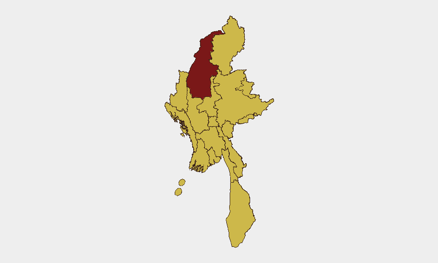
Sagaing Region dominates threat landscape at 97.4, driven by active resistance mobilization, junta air operations, and contested territory. Yangon (68.7) reflects urban instability and concentration of civilian/business infrastructure, while Rakhine (67.4) has emerged as the immediate operational flashpoint with documented civilian casualties and infrastructure destruction in the last 48 hours. The clustering of 10 regions at 67.4 risk indicates dispersed conflict nodes rather than a single theater, complicating both military prediction and civilian protection; the contrast between Sagaing's elevated score and the peer-level ratings of Mandalay, Shan, Kachin, and Tanintharyi suggests Sagaing reflects higher resistance activity, while other regions face equivalent ambient instability from military presence, ethnic tensions, or narcotics-trade violence.
How GeoBit Would Assist
Corporate teams with personnel or assets in Myanmar should employ AOI Monitoring & Early Warning on Sagaing, Yangon, and Rakhine with persistent satellite and OSINT alerting; Conflict & Military battle mapping and force structure tracking to plot junta air bases, known resistance positions, and recent strike patterns; and Routing & Network Analysis to model safe corridors and alternative journey planning around active combat zones. OSINT fusion and sentiment analysis on resistance media and domestic news feeds provides real-time event corroboration and trajectory flagging, while GIS & Spatial Analysis overlays civilian infrastructure (offices, residences, supply chains) against mapped threat zones.
7-Day Outlook
Rakhine State will likely remain under sustained junta pressure with continuing air operations; resistance forces are demonstrating offensive capability in Mandalay and Kayin, suggesting the conflict will not consolidate into static lines. Civilian casualty risk remains high in Rakhine and peripheral towns, and supply-chain disruption should be expected across Sagaing and northern routes.
Highest-Risk Areas — Ranked
| # | State / Region | Risk |
|---|---|---|
| 1 | Sagaing Region | 97.4 |
| 2 | Yangon | 68.7 |
| 3 | Tanintharyi Region | 67.4 |
| 4 | Shan State | 67.4 |
| 5 | Chin | 67.4 |
| 6 | Kachin State | 67.4 |
| 7 | Wa State (Northern Region) | 67.4 |
| 8 | Magway | 67.4 |
| 9 | Mandalay | 67.4 |
| 10 | Rakhine | 67.4 |
| 11 | Ayeyarwady | 67.4 |
| 12 | Naypyitaw Union Territory | 67.4 |
Sources
Previous Daily Briefs
A new Myanmar brief is written every day — each with its own risk map and downloadable CSV. Here's the last week; use the calendar to go further back.
📅 Browse every day by calendar →
Highlighted days have a brief. Tap a day for that day's map & analysis, or “csv” for that day's dataset ($5).
Atlas — our AI intelligence desk — emails them this snapshot personally. Nothing else, no list.