Situation Summary
Niger remains under acute strain from overlapping security pressures: a military junta consolidating control, tension with Western partners (particularly France), and persistent extremist and criminal activity in the Sahel. The country ranks #27 globally on GeoBit's composite threat index (score 64) with 12 tracked events. Recent signals point to internal political friction—including threats directed at the junta and detentions of military personnel—alongside routine counterinsurgency operations and border tensions with Nigeria.
Key Developments
- 2026-07-29 · Niamey/National · Conventional Military Force: Police Commissioner engaged in confrontation or show-of-force against state apparatus, suggesting internal security service friction within the capital region.
- 2026-07-28 · National · Corporate Threat: Direct threat issued against a company; nature and sectoral affiliation not yet clarified. Companies in extractive, telecom, and logistics sectors should verify operational security protocols.
- 2026-07-27 · Niamey/National · Junta Criticism: Public commentator issued threat against ruling military junta; reflects ongoing domestic political dissent.
- 2026-07-27 · National · Franco-Nigerien Tension: Niger government issued public disapproval statement toward Paris, consistent with broader diplomatic rupture trajectory since the 2023 coup.
- 2026-07-26 · Multiple Locations · Detention Operations: Series of arrests and detentions targeting military battalion personnel, Nigerien nationals, and Nigerian nationals; pattern suggests counterinsurgency sweeps or cross-border security operations.
- 2026-07-26 · Border Region · Cross-Border Investigation: Niger initiated investigation into Nigeria-linked persons or incidents, likely related to cross-border militant or trafficking activity.
Note: No newly confirmed discrete security incidents (firefights, bombings, mass casualty events) were corroborated in the prior 24–48 hours within Niger's borders. Signals reflect political friction, administrative action, and diplomatic posturing rather than acute kinetic threat.
Highest-Risk Areas
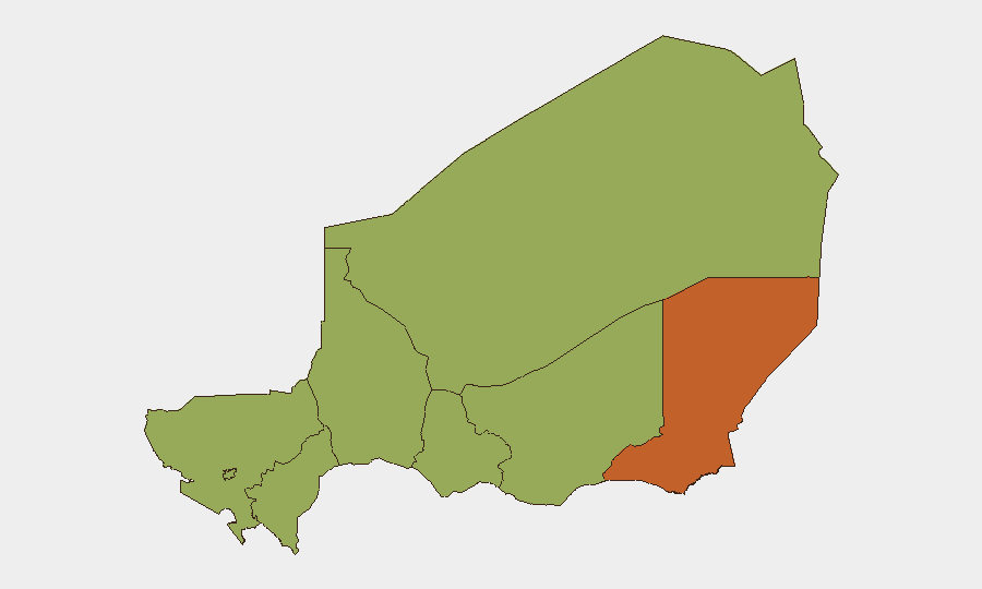
Diffa Region (risk 47 points above national average) remains the primary flashpoint, driven by Boko Haram and ISWAP presence along the Lake Chad basin and Nigerian border. Agadez and Niamey both register 47 risk points: Agadez faces smuggling, militant transit, and uranium-sector security threats, while Niamey concentrates political volatility and security-force friction. Zinder, Tillabéri, Tahoua, Dosso, and Maradi (all 44.7 risk points) form a secondary ring of concern, with ongoing banditry, inter-communal tension, and militant infiltration. The eastern and central Sahel belt remains the dominant driver of Niger's national risk profile.
How GeoBit Would Assist
Security teams with people or assets in Niger should deploy Intel Sweep and multi-language OSINT to track junta messaging, French diplomatic posture, and militant group signaling across X, Telegram, and regional media—early warning of escalation. AOI Monitoring & Early Warning focused on Diffa, Agadez, and Niamey can provide persistent alerting if political friction becomes kinetic or if cross-border operations spike. Network & Actor Analysis tied to detentions, police-junta friction, and Nigerian border investigations will clarify whether current arrests signal a broader security reorganization that affects travel, checkpoints, or business continuity.
7-Day Outlook
Franco-Nigerien diplomatic tension and internal junta friction are unlikely to resolve within seven days; companies should expect continued visa/administrative delays and heightened checkpoint activity. Diffa Region and broader Sahel operations will remain routine but persistent; no major tactical escalation is predicted absent new trigger events. Monitor detention patterns and police-military coordination closely—rapid expansion could signal either instability or a security reorganization that affects operations.
Highest-Risk Areas — Ranked
| # | State / Region | Risk |
|---|---|---|
| 1 | Diffa Region | 74.7 |
| 2 | Agadez Region | 47 |
| 3 | Niamey | 47 |
| 4 | Zinder Region | 44.7 |
| 5 | Tillabéri Region | 44.7 |
| 6 | Tahoua Region | 44.7 |
| 7 | Dosso Region | 44.7 |
| 8 | Maradi Region | 44.7 |
Sources
Previous Daily Briefs
A new Niger brief is written every day — each with its own risk map and downloadable CSV. Here's the last week; use the calendar to go further back.
📅 Browse every day by calendar →
Highlighted days have a brief. Tap a day for that day's map & analysis, or “csv” for that day's dataset ($5).
Atlas — our AI intelligence desk — emails them this snapshot personally. Nothing else, no list.