Situation Summary
Sudan remains the second-highest global conflict threat, driven by active civil war between the Sudanese Armed Forces (SAF) and Rapid Support Forces (RSF) spanning multiple theatres. Over the past 48 hours, fighting has intensified across the Kordofan region, the El Fasher corridor, and Khartoum State, while criminal exploitation of security vacuums has accelerated in secondary urban centres. International statements and congressional disapproval on 1–2 August signal heightened diplomatic pressure, but no immediate ceasefire or de-escalation pathway is evident.
Key Developments
- El-Obeid, North Kordofan (31 Jul): RSF–SAF clashes and shelling intensified over 48 hours; thousands of displaced residents face renewed threat as RSF units prepare possible assault on army-held positions.
- Dilling, South Kordofan (31 Jul): RSF and SPLM-N forces shelled residential areas, causing civilian casualties and further displacement amid ongoing Kordofan theatre fighting.
- Kadugli area, South Kordofan/Abyei corridor (31 Jul): Drone and artillery harassment of UNISFA logistics facilities resumed over two days, continuing a pattern of attacks on peacekeeping and supply infrastructure.
- El Fasher–North Darfur corridor (31 Jul): Fresh RSF operations and village-level violence reported, including burning of rural communities and forced displacement as RSF consolidates control.
- Southern Omdurman/Al-Salha, Khartoum State (31 Jul): Armed gang activity and home invasions surged in recent days; multiple armed robberies and at least two deaths in Al-Salha attributed to criminal networks exploiting the security vacuum.
- Rabak, White Nile State (night of 31 Jul): Escalating night-time gang violence, including murder during a home robbery attempt, has heightened civilian fear and prompted calls for stronger local security patrols.
- Port Sudan, Red Sea State (31 Jul): Extreme heatwave and continuing electricity shortages have severely disrupted daily life and increased health risks; emergency advisories issued over heatstroke and infrastructure strain.
- Omdurman–El-Obeid export route, North Kordofan (31 Jul): SAF consolidation and clearance operations continued along recently recaptured towns (Um Sayala, Bara, Jabra al-Sheikh, Um Qirfa, Jarejkh) on the strategic export highway.
Highest-Risk Areas
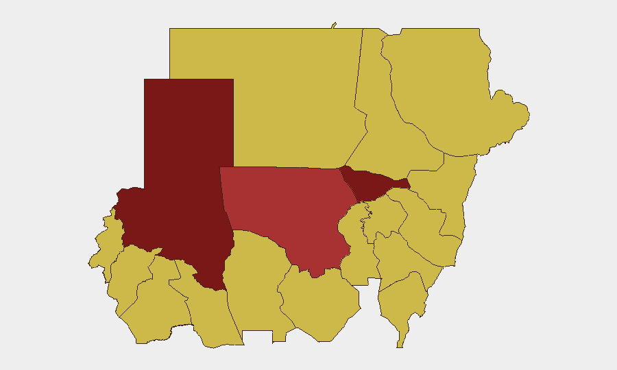
Al Khartum and North Darfur State both carry composite risk scores of 98.5, reflecting active combat, displacement crises, and criminal exploitation in the capital and sustained RSF operations in Darfur. North Kordofan (78.5) and the eastern states (Blue Nile, River Nile, Aj Jazira, Red Sea, Al Qadarif, Kassala, Sennar) at 68.5 each are secondary conflict zones and humanitarian chokepoints. The Kordofan theatre—spanning North, South, and West Kordofan—is currently the kinetic flashpoint; RSF pressure on El-Obeid and army-held positions suggests imminent escalation in that corridor.
How GeoBit Would Assist
Security teams should use AOI Monitoring & Early Warning to track Khartoum State and Kordofan frontlines with persistent alerting on RSF/SAF unit movements and clashes. Battle Mapping and Force Structure tracking will clarify army consolidation along the export corridor and RSF assault readiness around El-Obeid. Multi-language OSINT and entity extraction on local Sudanese media, Telegram, and community sources will surface emerging criminal networks in Omdurman and secondary cities, enabling duty-of-care teams to brief staff on kidnapping and robbery hotspots in near real-time.
7-Day Outlook
Intensified fighting around El-Obeid over the next 7 days is likely as RSF presses its assault on SAF-held areas; secondary cities (Rabak, Kosti) will see continued criminal violence. Humanitarian access and power infrastructure degradation will worsen, particularly in Port Sudan. Diplomatic statements will likely increase without corresponding operational change.
Highest-Risk Areas — Ranked
| # | State / Region | Risk |
|---|---|---|
| 1 | Al Khartum | 98.5 |
| 2 | North Darfur State | 98.5 |
| 3 | North Kordofan State | 78.5 |
| 4 | Blue Nile | 68.5 |
| 5 | River Nile State | 68.5 |
| 6 | Aj Jazira | 68.5 |
| 7 | Red Sea State | 68.5 |
| 8 | Al Qadarif State | 68.5 |
| 9 | Kassala State | 68.5 |
| 10 | Sennar State | 68.5 |
| 11 | Central Darfur State | 68.5 |
| 12 | South Darfur State | 68.5 |
Sources
Previous Daily Briefs
A new Sudan brief is written every day — each with its own risk map and downloadable CSV. Here's the last week; use the calendar to go further back.
📅 Browse every day by calendar →
Highlighted days have a brief. Tap a day for that day's map & analysis, or “csv” for that day's dataset ($5).
Atlas — our AI intelligence desk — emails them this snapshot personally. Nothing else, no list.