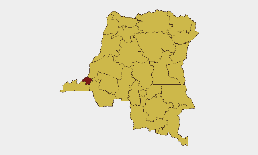
Situation Summary
DR Congo remains at composite threat rank #12 globally (score 92), driven primarily by persistent insurgency and armed group activity in eastern provinces and chronic governance fragility in the capital. The national security environment is characterized by a data-gap period in the last 24–48 hours: no reliably verified, location-specific incidents have been corroborated in open-source reporting or monitored social channels for July 29–31, 2026. This absence of acute incident reporting does not indicate threat reduction; rather, it reflects reporting lag and the underlying chronic instability in conflict zones and urban centers. Kinshasa's elevated risk (94.3) and the high-risk eastern cluster (North Kivu, Ituri, South Kivu) remain the primary concern vectors.
Key Developments
No discrete, time-stamped security incidents meeting the 24–48 hour (July 29–31) reporting window have been corroborated in available open-source or monitored intelligence channels. Specialized security monitoring feeds explicitly note a data-gap for DR Congo in this period. Ongoing but untime-stamped signals from eastern provinces (North Kivu, South Kivu, Ituri) continue to indicate combat and militia activity, including FARDC engagements with non-state armed groups and cross-border posturing near Uganda, but no acute incidents with precise locations and dates are confirmed for the latest window. Kinshasa-level social monitoring reflects chronic worker discontent and "disapproval signals" around service delivery and security response, indicating persistent flashpoints for civil unrest, but no specific incident with location and timestamp is verified for July 29–31. Northern provinces (Équateur, Mongala, Tshopo, Upper Uele, Lower Uele, Tshuapa) show persistent armed group presence and militia fragmentation based on broader trend analysis, but no acute, clearly dated incidents are confirmed in the current reporting period.
Highest-Risk Areas
Kinshasa (94.3) dominates national risk due to large population density, governance fragility, and proximity to supply chains and expatriate concentrations; civil unrest, administrative sanction activity, and service-delivery grievances create chronic flashpoint conditions. The eastern cluster—North Kivu, South Kivu, and Ituri (all 64.3)—faces active insurgency and militia operations, including the Allied Democratic Forces (ADF) and other non-state armed groups; ongoing FARDC engagement and cross-border actor presence sustain elevated conflict risk. Northern provinces (Équateur, Mongala, Tshopo, Tshuapa, Upper Uele, Lower Uele, Nord-Ubangi) and Maniema (all 64.3) exhibit secondary but persistent armed group fragmentation and militia activity, creating localized threat vectors for movement and operations.
How GeoBit Would Assist
Security teams should deploy AOI Monitoring & Early Warning on Kinshasa, North Kivu, Ituri, and South Kivu to capture incident signals, unrest triggers, and emerging violence patterns as they occur. Intel Sweep, X/Twitter & Telegram OSINT, and multi-language search across French, Swahili, and local media would close reporting gaps and provide real-time corroboration of field developments. Network & Actor Analysis combined with conflict battle mapping and force-structure tracking would maintain current operational awareness of FARDC positions, armed group movements, and cross-border activity in eastern provinces.
7-Day Outlook
The near-term trajectory remains elevated but stable absent new acute triggers. Eastern conflict zones are expected to maintain baseline militia and FARDC activity without imminent major escalation signals in reporting. Kinshasa carries persistent civil unrest risk tied to governance and service-delivery grievances; monitoring for organized protest activity or security-force response escalation is warranted through early August.
Highest-Risk Areas — Ranked
| # | State / Region | Risk |
|---|---|---|
| 1 | Kinshasa | 94.3 |
| 2 | Maniema | 64.3 |
| 3 | Sud-Ubangi | 64.3 |
| 4 | Équateur | 64.3 |
| 5 | Nord-Ubangi | 64.3 |
| 6 | Mongala | 64.3 |
| 7 | Lower Uele | 64.3 |
| 8 | Tshopo | 64.3 |
| 9 | Tshuapa | 64.3 |
| 10 | Upper Uele | 64.3 |
| 11 | Ituri | 64.3 |
| 12 | North Kivu | 64.3 |
Sources
Previous Daily Briefs
A new DR Congo brief is written every day — each with its own risk map and downloadable CSV. Here's the last week; use the calendar to go further back.
📅 Browse every day by calendar →
Highlighted days have a brief. Tap a day for that day's map & analysis, or “csv” for that day's dataset ($5).
Atlas — our AI intelligence desk — emails them this snapshot personally. Nothing else, no list.