Situation Summary
Iran is engaged in active multi-front conflict with US, Israeli, Saudi, and coalition forces across conventional military, naval, and infrastructure domains as of July 20–21, 2026. Escalation is accelerating: US strikes on Iranian nuclear and coastal military infrastructure are being met with Iranian missile and naval interdiction operations, alongside explicit threats of proxy retaliation (Houthis, Bab el-Mandeb closure). The security environment has shifted from regional proxy tension to direct state-on-state kinetic action, with civilian infrastructure, commercial shipping, and foreign nationals now explicitly at risk.
Key Developments
- Karun Nuclear Power Plant, Khuzestan Province (July 21): Iran's IAEA mission reported US missile strikes on the facility, signaling potential radiological and safety escalation in southwest Iran's industrial corridor.
- Strait of Hormuz maritime interdiction (July 21): IRGC halted a Kuwaiti oil tanker and reported two additional tankers caught fire in disputed waters south of Hormuz, indicating active maritime blockade and vessel-targeting operations affecting global shipping.
- US strikes on Bandar Abbas and Hormozgan Province (July 20–21): Ongoing daylight strikes on Iranian coastal defenses, missile sites, and Qeshm Island reported as part of Operation Epic Fury follow-on waves, with direct impact on southern infrastructure and port operations.
- Iranian ground strike on Camp Arifjan, Kuwait (July 21): Iran's army claimed attack on US HIMARS systems in Kuwait as the 18th phase of Operation Thunderbolt, indicating cross-border kinetic operations against coalition military installations.
- Iranian retaliation threats and proxy activation (July 20–21): Tehran publicly stated readiness to strike regional infrastructure if US strikes continue and requested Houthi readiness to close Bab el-Mandeb Strait, escalating multi-vector energy and maritime risk.
- Diplomatic incident in Tehran (July 20–21): French embassy staff detained and one physically assaulted by Iranian security personnel, indicating hardened security posture toward foreign nationals and diplomatic missions in the capital.
Highest-Risk Areas
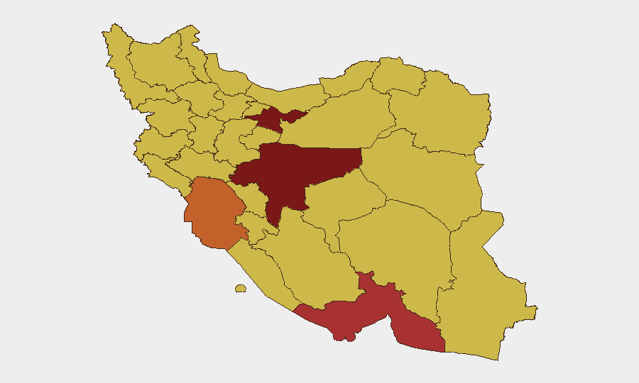
Tehran Province (96.5) and Isfahan Province (87.4) remain highest-ranked due to capital concentration of government, military, and diplomatic activity; however, Hormozgan Province (79.5) and Khuzestan Province (74.8) have emerged as acute operational risk zones. The south and southwest are now active combat/strike theaters—Hormozgan hosts Bandar Abbas naval operations and Qeshm Island (targeted July 20–21); Khuzestan contains the Karun Nuclear Plant and proximity to Iraq/Kuwait border where cross-border missile strikes are occurring. Risk in these provinces is no longer theoretical but kinetic and immediate.
How GeoBit Would Assist
Security teams should deploy AOI Monitoring & Early Warning on Hormozgan, Khuzestan, and Tehran to detect military strikes, IRGC naval movements, and power-grid/port disruptions in real time. Maritime & Aviation tracking paired with Routing & Network Analysis enables alternative logistics planning around Hormuz and Bab el-Mandeb closure scenarios. Conflict & Military (battle mapping, force structure) and Intel Sweep (multi-language feeds, sentiment analysis) provide 24-hour visibility into Iranian and US/coalition force posture, proxy activation signals, and escalation thresholds to support duty-of-care evacuation and containment decisions.
7-Day Outlook
Escalation trajectory is steep: nuclear infrastructure strikes and threatened closure of two global chokepoints (Hormuz, Bab el-Mandeb) suggest potential for regional energy shock and supply-chain disruption within 48–72 hours. Iranian retaliation is likely to follow a cycle of US strikes; proxy activation (Houthis, Shia militias) and maritime harassment will persist. Commercial operations in Hormozgan and Khuzestan should assume degraded infrastructure and heightened security risk through at least late July.
Highest-Risk Areas — Ranked
| # | State / Region | Risk |
|---|---|---|
| 1 | Tehran Province | 96.5 |
| 2 | Isfahan Province | 87.4 |
| 3 | Hormozgan Province | 79.5 |
| 4 | Khuzestan Province | 74.8 |
| 5 | Bushehr Province | 70.6 |
| 6 | Kurdistan Province | 70.2 |
| 7 | East Azerbaijan Province | 70 |
| 8 | Fars Province | 69.1 |
| 9 | Sistan and Baluchestan Province | 68.7 |
| 10 | Yazd Province | 68.5 |
| 11 | Gilan Province | 67.6 |
| 12 | Lorestan Province | 67.3 |
Previous Daily Briefs
A new Iran brief is written every day — each with its own risk map and downloadable CSV. Here's the last week; use the calendar to go further back.
📅 Browse every day by calendar →
Highlighted days have a brief. Tap a day for that day's map & analysis, or “csv” for that day's dataset ($5).
Atlas — our AI intelligence desk — emails them this snapshot personally. Nothing else, no list.