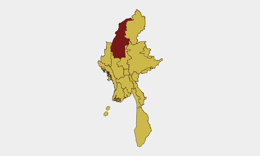
Situation Summary
Myanmar remains in active civil war, with the military junta conducting sustained air and ground operations against resistance forces across multiple regions. The conflict has escalated significantly in the past 48 hours, with documented airstrikes on civilian areas in Rakhine State, convoy attacks in Kayin and Mandalay regions, and ongoing riverine engagements in Sagaing. Civilian casualties and displacement are rising, and the information environment remains heavily constrained, limiting real-time visibility into the full scope of operations.
Key Developments
- Rakhine State airstrikes (19 July): Myanmar military conducted consecutive airstrikes on Ma‑Ei, Thandwe, Ponnagyun, and Gwa townships. Three 500‑lb bombs struck Ma‑Ei alone; at least five civilians killed and 14–30 injured, including Buddhist monks and children. Sustained aerial campaign across coastal townships indicates heightened short-term risk to civilian populations.
- Kawkareik convoy attack, Kayin State (19–20 July): Resistance forces attacked a junta reinforcement convoy, reportedly killing at least 15 soldiers. Major corridor between central Myanmar and Thai border remains under active conflict pressure.
- Natogyi Township attacks, Mandalay Region (19 July): PDF resistance forces attacked three junta positions, claiming at least five soldiers killed. Indicates active fighting in rural Mandalay and elevated road-travel risk.
- Chindwin River engagements, Sagaing Region (mid-July, reported 48h window): Resistance forces attacked junta convoy with RPGs, sinking one vessel and seizing logistics craft carrying food and military equipment. Reflects heightened risk to river traffic in highest-risk region.
- Yesagyo airstrike, Magway Region (19–20 July): Regime airstrikes hit Yesagyo Revolution Group base. Follows earlier July airstrikes in Pauk and Myaing townships (13–15 July) that killed four civilians and destroyed ~50 homes, with regime forces remaining in area.
- Indawgyi area fighting, Kachin State (7 July, recirculated 18–20 July): KIA and KPDF forces captured SNA camp near Indawgyi Lake, seizing weapons and equipment. Re-circulation across resistance channels suggests ongoing consolidation and further volatility in contested areas.
Highest-Risk Areas
Sagaing Region (risk 97.3) remains the primary driver of national threat score, with active riverine logistics interdiction and sustained resistance operations. Rakhine State (ranked 10th but operationally critical) is experiencing the most acute civilian harm, with documented airstrikes on populated towns and infrastructure damage on 19 July alone. Mandalay and Magway regions show sustained resistance pressure on regime positions, reflected in documented attacks on convoys and bases in the past 48 hours. All four regions are experiencing combined air, ground, and logistics-corridor warfare, creating compounding risks to civilian movement, supply chains, and infrastructure.
How GeoBit Would Assist
Corporate security teams would deploy AOI Monitoring & Early Warning on high-risk townships (Ma‑Ei, Thandwe, Natogyi, Kawkareik) to detect resumed airstrikes or major ground operations in real time. Routing & Network Analysis capabilities would allow duty-of-care teams to model alternative supply and personnel movement routes away from documented conflict zones and river corridors. Conflict & Military battle mapping and multi-language OSINT fusion of resistance and domestic monitoring channels would provide continuous corroboration of attacks and casualty figures where official sources are unavailable.
7-Day Outlook
Aerial operations in Rakhine and Magway are likely to continue, with the regime maintaining offensive pressure across multiple regions. Resistance forces are expected to sustain convoy interdiction and attacks on junta positions, particularly in Sagaing, Kayin, and Mandalay corridors. Civilian displacement and collateral damage will likely increase absent de-escalation, elevating humanitarian and duty-of-care risks for organizations operating in or transiting these areas.
Highest-Risk Areas — Ranked
| # | State / Region | Risk |
|---|---|---|
| 1 | Sagaing Region | 97.3 |
| 2 | Yangon | 68.6 |
| 3 | Tanintharyi Region | 67.3 |
| 4 | Shan State | 67.3 |
| 5 | Chin | 67.3 |
| 6 | Kachin State | 67.3 |
| 7 | Wa State (Northern Region) | 67.3 |
| 8 | Magway | 67.3 |
| 9 | Mandalay | 67.3 |
| 10 | Rakhine | 67.3 |
| 11 | Ayeyarwady | 67.3 |
| 12 | Naypyitaw Union Territory | 67.3 |
Sources
Previous Daily Briefs
A new Myanmar brief is written every day — each with its own risk map and downloadable CSV. Here's the last week; use the calendar to go further back.
📅 Browse every day by calendar →
Highlighted days have a brief. Tap a day for that day's map & analysis, or “csv” for that day's dataset ($5).
Atlas — our AI intelligence desk — emails them this snapshot personally. Nothing else, no list.