Situation Summary
Niger remains ranked #27 globally (composite threat score 69) with persistent structural security risks driven by terrorism, violent crime targeting foreigners, and armed-group activity in border and northern regions. No new corroborated security incidents—attacks, protests, kidnappings, or infrastructure disruptions—have been recorded in open sources or regional media over the last 24–48 hours (29–31 July 2026). The threat environment is stable in the immediate term, though underlying conditions favor sporadic militant and criminal activity, particularly in Niamey and outlying high-risk zones.
Key Developments
- No new discrete incidents verified in the last 24–48 hours. Cross-referenced review of Nigerien media outlets (Agence Nigérienne de Presse, Journal du Niger, ActuNiger), Geobit event feeds, and open-source security bulletins confirms the absence of newly time-stamped attacks, clashes, protests, or civil unrest nationwide (29–31 July 2026).
- Niamey remains the highest-risk urban center. The capital (risk score 78.2) concentrates political, military, and diplomatic infrastructure, with documented historical targeting by armed groups and baseline criminal threats to expatriates; no new incident reported in the last 48 hours, but operational posture remains elevated.
- Border and northern regions continue elevated baseline threat. Agadez, Diffa, Tillabéri, Tahoua, and other northern/eastern regions (all risk 48.2) remain zones of recurring cross-border militant activity and small-arms engagements; recent incidents cited in current media coverage are dated early–mid July and predate the last 24–48-hour window.
- Sahel force expansion announced (26 July, policy development). The Alliance of Sahel States—including Niger—announced plans to expand joint counter-insurgency operations to 18,000 troops in response to ongoing Islamist violence; this is a military/political posture shift, not a discrete new security incident.
- Earlier July incidents remain notable context but are historical. The 18 June attack on Diori Hamani Airport (Niamey) and 17 July attack on military personnel near the Mali–Burkina Faso border are widely referenced in current commentary but occurred outside the 24–48-hour reporting window and do not constitute new developments.
Highest-Risk Areas
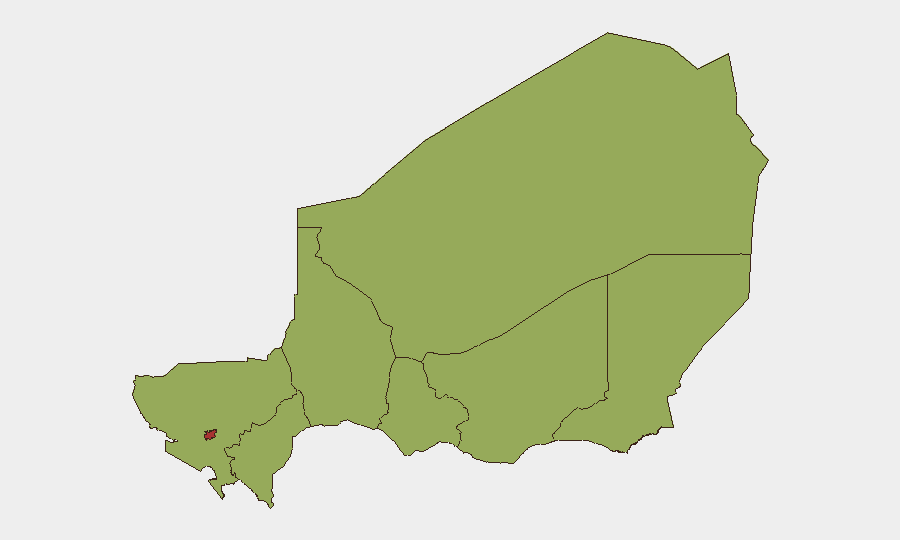
Niamey (78.2) significantly outranks all other regions and represents the primary concentration of risk due to its status as the political, economic, and diplomatic hub, combined with documented militant targeting and urban crime networks targeting foreign nationals. The remaining seven regions (Agadez, Zinder, Diffa, Tillabéri, Tahoua, Dosso, Maradi—each 48.2) form a secondary tier driven by proximity to ungoverned border zones, cross-border militant sanctuaries, and recurring small-arms conflict. Northern and eastern regions—particularly Diffa and Tillabéri—bear the highest absolute exposure to jihadist and transnational criminal networks active along Niger's borders with Mali, Burkina Faso, and Nigeria.
How GeoBit Would Assist
Security teams with personnel or assets in Niger should deploy AOI Monitoring & Early Warning on Niamey and high-risk northern regions to detect emerging incidents in real time, coupled with Intel Sweep and multi-language OSINT fusion to corroborate local media, social signals (X/Telegram), and regional security feeds. Routing & Network Analysis enables rapid identification of alternative travel corridors and safe routes during periods of elevated activity, while conflict and military force-structure tracking provides situational awareness on armed-group positions and government operations in border zones.
7-Day Outlook
No acute security escalation is forecast over the next 7 days based on current open-source signals. Structural risks—militant activity, criminal networks, and sporadic clashes in border areas—remain endemic, with baseline threat to foreign nationals stable. Continued monitoring of northern regions and Niamey is essential; any resumption of organized attacks or political instability would likely appear first in regional media and social channels within 12–24 hours.
Highest-Risk Areas — Ranked
| # | State / Region | Risk |
|---|---|---|
| 1 | Niamey | 78.2 |
| 2 | Agadez Region | 48.2 |
| 3 | Zinder Region | 48.2 |
| 4 | Diffa Region | 48.2 |
| 5 | Tillabéri Region | 48.2 |
| 6 | Tahoua Region | 48.2 |
| 7 | Dosso Region | 48.2 |
| 8 | Maradi Region | 48.2 |
Sources
Previous Daily Briefs
A new Niger brief is written every day — each with its own risk map and downloadable CSV. Here's the last week; use the calendar to go further back.
📅 Browse every day by calendar →
Highlighted days have a brief. Tap a day for that day's map & analysis, or “csv” for that day's dataset ($5).
Atlas — our AI intelligence desk — emails them this snapshot personally. Nothing else, no list.