Situation Summary
South Sudan remains at elevated risk (rank #32 globally, composite score 65), with the primary driver continuing to be active internal conflict and inter-communal violence. The past week saw a significant escalation in the Abyei disputed territory, where ethnic clashes between Ngok Dinka and Misseriya communities killed at least 26 people and injured 82, marking the most serious single incident in the current reporting window. Concurrent tensions along the Juba–Torit highway and political friction in the capital suggest a pattern of localized but persistent security stress across multiple regions.
Key Developments
- 15 September, Amiet Common Market (Abyei): Ethnic clashes between Ngok Dinka and Misseriya communities erupted following separate killings on 14–15 September, resulting in 26 confirmed fatalities and 82 injured. The violence halted market operations and forced civilian displacement in this Sudan–South Sudan border flashpoint.
- 15 September, Al‑Naam border market (Sudan–South Sudan frontier): Armed clashes near Abyei killed between 9 and 40 civilians (local reports), disrupted cross-border trade, and forced fleeing of traders and families; looting of the market was reported.
- 17 September, Abyei region security response: UNISFA reinforced its security presence around Abyei town and Amiet market to deter retaliatory attacks and stabilize the area following mid-week violence. Amiet market remained closed or severely disrupted, with ongoing displacement risks.
- 15–17 September, Juba (Central Equatoria): A physical confrontation at the Ministry of Justice and Constitutional Affairs involving a comedian and a civil-society official resulted in arrests, reflecting civic tensions. Separately, the High Court suspended the Union of Journalists of South Sudan election, heightening media-sector and press-freedom friction in the capital.
- Mid-September, Juba–Torit highway (Central & Eastern Equatoria): Governors of Central and Eastern Equatoria convened to address security and trade concerns on this key route, citing reports of harassment, looting, and livestock abduction affecting civilian and cargo movement between Juba and the east.
- 16 September, Abiemnhom (Unity State): A UN Special Representative-level field visit to conflict-affected communities in Unity State underscored ongoing security and humanitarian pressure in the country's highest-risk region.
Highest-Risk Areas
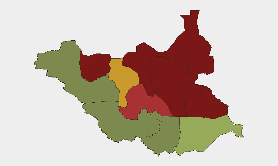
Unity, Jonglei, Upper Nile, and the Greater Pibor Administrative Area dominate the sub-national risk landscape, collectively scoring 87–95 on GeoBit's composite index. These northern and northeastern states face entrenched armed-group presence, inter-communal competition for pastoral and water resources, and limited state capacity, creating persistent risk to civilians and commercial activity. The Abyei disputed territory, while administratively complex, has become a critical flashpoint; the 15 September clashes exemplify how unresolved border status and resource competition generate rapid escalation. Central Equatoria, including the capital Juba, registers lower but non-negligible risk (35), driven by political contestation and highway insecurity rather than active large-scale conflict.
How GeoBit Would Assist
Security teams with personnel or assets in South Sudan should employ persistent AOI monitoring and early-warning alerting on Unity, Jonglei, and Abyei to detect renewed clashes or displacement. Routing and network analysis capabilities can identify safer alternative routes on the Juba–Torit highway and around Abyei, minimizing exposure to known harassment and looting zones. Conflict mapping and entity-network analysis help track inter-communal and armed-group movements, while sentiment and event-stream OSINT on regional media and social platforms provide early indication of escalating tension before violence materializes.
7-Day Outlook
Abyei remains volatile in the immediate term; UNISFA's reinforced presence should suppress immediate retaliatory violence, but underlying ethnic tensions and resource disputes are unlikely to resolve quickly. Northern pastoral regions (Unity, Jonglei) will continue to experience seasonal resource competition and armed-group activity. Monitoring for secondary incidents along cross-border routes and within Juba's civic and political spaces should remain elevated through late September.
Highest-Risk Areas — Ranked
| # | State / Region | Risk |
|---|---|---|
| 1 | Unity | 95 |
| 2 | Jonglei | 93 |
| 3 | Upper Nile | 88 |
| 4 | Greater Pibor Administrative Area | 87 |
| 5 | Northern Bahr el Ghazal | 82 |
| 6 | Lakes | 78 |
| 7 | Warrap | 72 |
| 8 | Ruweng Administrative Area | 68 |
| 9 | Eastern Equatoria | 52 |
| 10 | Western Equatoria | 38 |
| 11 | Central Equatoria | 35 |
| 12 | Western Bahr el Ghazal State | 28 |
Sources
Previous Weekly Briefs
A new South Sudan brief is written every Monday, covering the week — each with its own risk map and downloadable CSV. Use the calendar to go further back.
- September 14, 2026
- September 7, 2026
- September 1, 2026
- August 30, 2026
- August 28, 2026
- August 26, 2026
- August 24, 2026
📅 Browse past briefs by calendar →
Highlighted days have a brief. Tap a day for that day's map & analysis, or “csv” for that day's dataset ($5).
Atlas — our AI intelligence desk — emails them this snapshot personally. Nothing else, no list.