Situation Summary
Sudan remains the world's second-highest composite security threat (score 98), driven by active civil war between the Sudanese Armed Forces (SAF) and Rapid Support Forces (RSF) across multiple fronts. Over the past 48 hours, SAF has executed its largest ground offensive since retaking Khartoum, recapturing five strategic towns in North Kordofan and reopening a critical supply corridor—a significant tactical shift that does not reduce overall instability. Simultaneous RSF drone strikes on El-Obeid and civilian areas, border-crossing closures, and reported defections underscore a conflict in flux with heightened risk to civilian populations and critical infrastructure across central and western Sudan.
Key Developments
- North Kordofan – Bara, Gabra al-Sheikh, Um Sayala, Um Girfa, Gerigikh – 31 July–1 August 2026
SAF forces recaptured five towns in a 300 km² offensive zone, dismantling a major RSF logistics corridor along the Saderat Road. The operation, supported by drone strikes, represents the largest SAF ground push since Khartoum's retake; claims of reopening the Al Sadarat highway for fuel and troop movement remain unverified but alter central-Sudan convoy and travel risk profiles.
- North Kordofan – El-Obeid city – late July–early August 2026
RSF launched a new wave of daily drone strikes on El-Obeid, destroying the main power transformer and striking residential areas and the airport district. Reported civilian casualty toll: 22 killed and 19 wounded across multiple incidents, with ongoing bombardment creating severe infrastructure and travel risk.
- North Kordofan – Gamama area near El-Obeid – 30 July 2026
Sudan Doctors Network reported nine civilians killed and 14 wounded in an RSF attack on Gamama, framing the El-Obeid periphery as a high-risk zone for civilian casualties and medical evacuation challenges.
- West Darfur – Adre border crossing (Sudan–Chad) – 30 July 2026
The main humanitarian aid and trade route into western Sudan was closed for 24 hours following RSF detention of two Chadian nationals. Reopened on 31 July after security negotiations, but incident signals potential for future cross-border disruption and border-area volatility.
- Omdurman (Khartoum State) – 31 July 2026
Forty-five RSF fighters defected and surrendered to the SAF, suggesting morale fractures within RSF ranks and potential for heightened internal security operations, surveillance, and arrest risk within Khartoum State.
- North Kordofan–Omdurman corridor – Al Sadarat highway – 31 July–1 August 2026
SAF seized control of the supply corridor linking Omdurman to El-Obeid, claiming reopening of a direct logistics route; strategic impact assessment ongoing, but immediate effect is altered road-movement risk along this central-Sudan axis.
Highest-Risk Areas
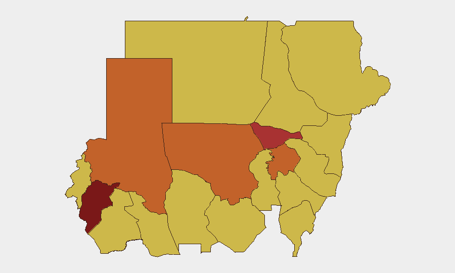
Central Darfur State (98.3) and Al Khartum (79.6) remain the top-ranked zones, but North Kordofan State (74.9) has emerged as the most volatile active conflict front over the past 48 hours, with both SAF offensive operations and RSF drone campaigns concentrated there. El-Obeid and surrounding towns face intense daily bombardment, civilian casualties, and infrastructure collapse (power, water), making the region unsuitable for non-essential personnel. West Darfur's Adre crossing and the broader North Darfur and Aj Jazira states (74.2, 73 respectively) remain critical humanitarian corridors and conflict zones; closure or disruption of these routes amplifies civilian suffering and complicates evacuation and aid access.
How GeoBit Would Assist
Security teams managing personnel or assets in Sudan should leverage Battle Mapping and Force Structure Tracking to monitor real-time SAF and RSF advances and position changes across North Kordofan and adjacent states. AOI Monitoring with Early Warning can provide persistent watch on key towns (El-Obeid, Bara, Adre crossing) and alert to new drone strikes, road closures, or major tactical shifts. Routing & Network Analysis supports alternative-route planning for critical supply runs and evacuation corridors, particularly if the Al Sadarat highway's SAF control disrupts established logistics chains.
7-Day Outlook
The SAF's momentum in North Kordofan may encourage further offensive operations, but RSF drone capability remains intact and will likely intensify in response. Civilian displacement, infrastructure degradation, and border-crossing volatility will continue to complicate humanitarian access and duty-of-care operations across western and central Sudan over the coming week.
Highest-Risk Areas — Ranked
| # | State / Region | Risk |
|---|---|---|
| 1 | Central Darfur State | 98.3 |
| 2 | Al Khartum | 79.6 |
| 3 | North Kordofan State | 74.9 |
| 4 | North Darfur State | 74.2 |
| 5 | Aj Jazira | 73 |
| 6 | Kassala State | 68.7 |
| 7 | Blue Nile | 68.3 |
| 8 | River Nile State | 68.3 |
| 9 | Red Sea State | 68.3 |
| 10 | Al Qadarif State | 68.3 |
| 11 | Sennar State | 68.3 |
| 12 | South Darfur State | 68.3 |
Sources
Previous Daily Briefs
A new Sudan brief is written every day — each with its own risk map and downloadable CSV. Here's the last week; use the calendar to go further back.
📅 Browse every day by calendar →
Highlighted days have a brief. Tap a day for that day's map & analysis, or “csv” for that day's dataset ($5).
Atlas — our AI intelligence desk — emails them this snapshot personally. Nothing else, no list.