Situation Summary
Iran is in an active and escalating military conflict with the United States and regional partners, marked by reciprocal strikes on military and infrastructure targets across Iranian territory and U.S. positions throughout the Middle East. As of 24 July 2026, the U.S. has conducted 11 consecutive nights of airstrikes on Iranian military infrastructure, while Iranian forces have responded with coordinated drone and missile attacks on U.S. bases in Jordan, Kuwait, and Bahrain, as well as critical digital infrastructure. Iran has declared the Strait of Hormuz closed and threatened targeting of regional oil, gas, electricity, and economic infrastructure if strikes continue, creating compounding risks to energy security, maritime transit, and supply-chain continuity across the Gulf. The conflict trajectory remains upward, with no de-escalation signals evident.
Key Developments
- Multiple Iranian locations, 22 July 2026 (overnight): U.S. Central Command executed its 11th consecutive night of airstrikes on Iranian military infrastructure, with strikes lasting approximately 75 minutes and covering multiple targets across Iranian territory.
- Al Azraq Air Base, Jordan, early 22 July 2026: Iranian armed forces launched drone attacks on U.S. accommodation, welfare, and equipment storage facilities, described as retaliation for ongoing U.S. strikes on Iranian sites.
- Camp al-Doha, western Kuwait, early 22 July 2026: Iran's army announced a large-scale drone attack on U.S. military units and their equipment depots in response to the broader U.S. campaign.
- Sheikh Isa Air Base, Bahrain, morning 22 July 2026: Iranian forces claimed strikes on U.S. equipment warehouses and aircraft maintenance hangars using Arash suicide drones.
- Amazon Web Services data facility, Bahrain, 22 July 2026: Iran's Armed Forces announced an attack on AWS infrastructure in Bahrain, characterizing it as critical command-and-control digital support for U.S. Central Command operations.
- Tehran (government level), 22 July 2026: President Masoud Pezeshkian chaired an emergency cabinet meeting approving measures to reduce electricity restrictions on manufacturers and support industrial production amid war-related energy-system strain.
- Strait of Hormuz and regional infrastructure, ongoing as of 22 July 2026: Iran's joint military command reiterated closure of the Strait of Hormuz and threatened targeting of regional oil, gas, electricity, and economic infrastructure if U.S. strikes continue.
Highest-Risk Areas
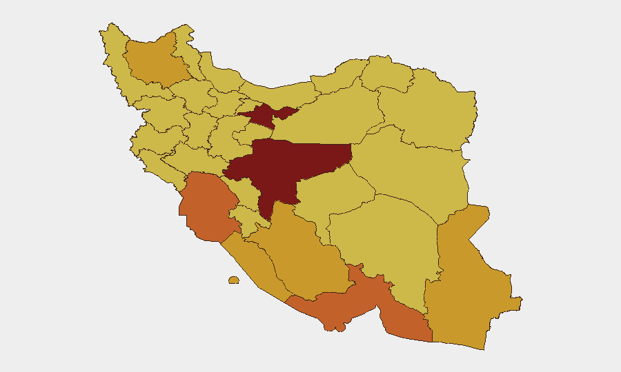
Tehran Province (risk 97.5) and Isfahan Province (risk 83.1) drive the composite threat ranking, reflecting concentration of political, military command-and-control, and critical infrastructure targets in these zones—making them primary focus areas for ongoing U.S. strikes. Khuzestan, Hormozgan, and East Azerbaijan provinces (risk range 72.6–75.1) present elevated risk due to proximity to the Strait of Hormuz, major energy infrastructure, and military installations; disruption to energy networks and maritime chokepoints in these regions will cascade across supply chains and global energy markets. Sistan and Baluchestan, Kurdistan, and Ilam provinces register sustained elevated risk (69–71.5) due to porous borders, limited central-government presence, and potential for cross-border operations or destabilization.
How GeoBit Would Assist
Security teams would deploy AOI Monitoring & Early Warning on Tehran, Isfahan, and energy-critical provinces to detect strike activity and infrastructure damage in real time, paired with satellite & imagery analysis to assess damage extent and recovery timelines. Maritime & aviation tracking, combined with conflict & military force-structure monitoring, would enable continuous assessment of Strait of Hormuz closure impacts and U.S./regional military posture shifts. Alternative routing & network analysis would support supply-chain and personnel-movement planning around closed maritime corridors and conflict zones.
7-Day Outlook
The U.S.–Iran cycle of reciprocal strikes shows no signs of immediate termination; additional Iranian attacks on Gulf-based U.S. assets are probable, with corresponding U.S. responses likely to expand targeting of Iranian command, control, and energy infrastructure. Regional and global energy markets will remain volatile, with sustained pressure on Strait of Hormuz transit and potential secondary impacts on commercial shipping and insurance rates. Risk to corporate operations and personnel in Tehran, Isfahan, and the southern Gulf provinces will remain acute through the near term.
Highest-Risk Areas — Ranked
| # | State / Region | Risk |
|---|---|---|
| 1 | Tehran Province | 97.5 |
| 2 | Isfahan Province | 83.1 |
| 3 | Khuzestan Province | 75.1 |
| 4 | Hormozgan Province | 74.3 |
| 5 | East Azerbaijan Province | 72.6 |
| 6 | Bushehr Province | 71.5 |
| 7 | Sistan and Baluchestan Province | 71.5 |
| 8 | Fars Province | 71 |
| 9 | Gilan Province | 69.9 |
| 10 | Kurdistan Province | 69.6 |
| 11 | Lorestan Province | 69.4 |
| 12 | Ilam Province | 69 |
Sources
Previous Daily Briefs
A new Iran brief is written every day — each with its own risk map and downloadable CSV. Here's the last week; use the calendar to go further back.
📅 Browse every day by calendar →
Highlighted days have a brief. Tap a day for that day's map & analysis, or “csv” for that day's dataset ($5).
Atlas — our AI intelligence desk — emails them this snapshot personally. Nothing else, no list.