Situation Summary
Myanmar remains in active civil war with composite threat score 97, driven by sustained conventional military clashes, airstrikes, and resistance operations across multiple regions. The past 48 hours have shown clustering of confirmed reports in Rakhine, Kayin, Mandalay, Magway, and Kachin states, with both junta airstrikes and armed group attacks documented. Recent threats directed at China and Taiwan, coupled with diplomatic investigation signals, indicate potential spillover into cross-border and international dimensions. The security trajectory remains volatile with no de-escalation indicators.
Key Developments
- Rakhine State (Ma-Ei, Thandwe, Ponnagyun, Gwa townships), 19 July 2026: Myanmar military conducted confirmed airstrikes including three 500-lb ordnance drops on Ma-Ei township; civilian casualties and injuries reported by multiple sources.
- Kawkareik, Kayin State, 19–20 July 2026: Armed resistance forces attacked a junta reinforcement convoy; opposition sources claimed multiple military personnel casualties.
- Natogyi Township, Mandalay Region, 19 July 2026: PDF (People's Defence Force) units conducted coordinated attacks on three junta positions; armed clashes with reported military fatalities.
- Yesagyo Township, Magway Region, 19–20 July 2026: Military airstrikes targeted reported resistance base locations.
- Indawgyi area, Kachin State, 18–20 July 2026: KIA/KPDF forces captured an SNA (Shan Nationalities Army) camp and seized weapons stockpiles; video documentation of engagement circulated.
- Yangon, 19–20 July 2026: Civil resistance activities documented including organized protests and symbolic demonstrations.
- Myanmar diplomatic posture, 23 July 2026: Threat signals issued toward China and Taiwan; separate investigation signal involving ambassador-level engagement recorded.
Highest-Risk Areas
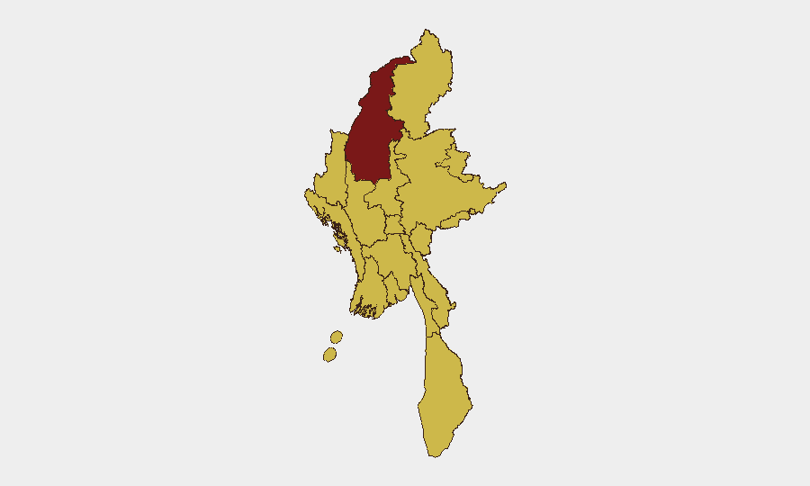
Sagaing Region stands isolated as the highest-risk sub-national area (98.1), likely reflecting sustained PDF-junta contestation and geographic proximity to armed group sanctuaries. Eleven remaining regions and states cluster at 68.1, indicating that risk is geographically distributed rather than concentrated—Tanintharyi, Shan, Chin, Kachin, Wa State (Northern Region), Magway, Mandalay, Rakhine, Ayeyarwady, Yangon, and Naypyitaw Union Territory all show equivalent composite scores. This flattened distribution reflects the civil war's nationwide scope, though recent event clustering in Rakhine, Kayin, Mandalay, and Magway suggests operational intensity in these zones over the past 72 hours.
How GeoBit Would Assist
Security teams operating in or near Myanmar should employ AOI Monitoring & Early Warning for persistent watch on highest-risk townships and border zones, with alert triggers tied to airstrike and armed clash patterns. Conflict & Military capabilities—including battle mapping, force-structure tracking, and weapons-capability analysis—enable rapid assessment of which armed groups control specific transport corridors and supply lines. GIS & Spatial Analysis combined with Satellite & Imagery Analysis allow near-real-time verification of infrastructure damage and personnel movement, critical for duty-of-care assessments and personnel routing decisions.
7-Day Outlook
No indicators suggest imminent ceasefire or significant de-escalation. Junta airstrikes are likely to continue in Rakhine, Magway, and Kachin; armed groups will sustain convoy attacks and position assaults. Cross-border dimensions (China, Thailand, Taiwan threat signals) may introduce additional pressure on movement and supply chains, particularly in border regions. Risk remains elevated across all sub-national areas; localized intensity may shift but overall conflict tempo is forecast to persist.
Highest-Risk Areas — Ranked
| # | State / Region | Risk |
|---|---|---|
| 1 | Sagaing Region | 98.1 |
| 2 | Tanintharyi Region | 68.1 |
| 3 | Shan State | 68.1 |
| 4 | Chin | 68.1 |
| 5 | Kachin State | 68.1 |
| 6 | Wa State (Northern Region) | 68.1 |
| 7 | Magway | 68.1 |
| 8 | Mandalay | 68.1 |
| 9 | Rakhine | 68.1 |
| 10 | Ayeyarwady | 68.1 |
| 11 | Yangon | 68.1 |
| 12 | Naypyitaw Union Territory | 68.1 |
Sources
Previous Daily Briefs
A new Myanmar brief is written every day — each with its own risk map and downloadable CSV. Here's the last week; use the calendar to go further back.
📅 Browse every day by calendar →
Highlighted days have a brief. Tap a day for that day's map & analysis, or “csv” for that day's dataset ($5).
Atlas — our AI intelligence desk — emails them this snapshot personally. Nothing else, no list.