Situation Summary
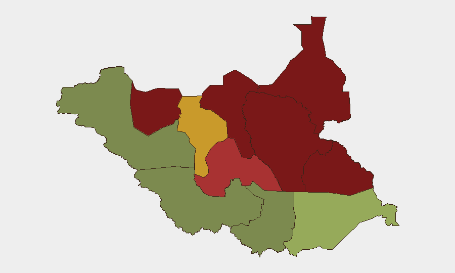
South Sudan faces elevated political and security volatility following President Salva Kiir's 23 September dissolution of the transitional unity government and appointment of a caretaker administration ahead of planned national elections. The past week saw renewed intercommunal violence, armed clashes in multiple states, and tightened security in the capital, with ceasefire-monitoring bodies reporting ambushes, civilian attacks, and armed-youth mobilization across several regions. The security picture remains fragmented by geography: the oil-rich north and northeastern states (Unity, Jonglei, Upper Nile, Greater Pibor) carry substantially higher risk than the more stable south and west, though political uncertainty now extends risk to the capital and national institutions. Trajectory is toward continued volatility through the election period, with displacement, humanitarian-access restrictions, and intercommunal violence likely to persist.
Key Developments
- Juba — 22 September: Security forces deployed joint patrols day and night and tightened security across parts of the capital in response to heightened political uncertainty. On 23 September, authorities placed security forces on high alert for three days amid government restructuring.
- Juba / National Government — 23 September: President Salva Kiir dissolved the transitional unity government and appointed a caretaker administration ahead of the country's planned first national elections, creating additional political instability and security risk.
- South Sudan (multiple locations) — 22 September: The ceasefire-monitoring mechanism CTSAMVM reported renewed confrontations involving organized forces, armed-youth mobilization, intercommunal violence, displacement, and movement restrictions. Specific hotspots included ambushes and civilian attacks in Central Equatoria and clashes in Ulang and Nasir counties (Upper Nile). Armed-youth violence continued along the Bor–Pibor–Duk corridor in Jonglei.
- Jonglei State (Duk and Twic East counties) — 25 September: Fighting between youth from the two counties killed at least 13 people and injured 26. Local officials reported the immediate clashes had stopped but searches continued and the toll could rise.
- Nasir, Upper Nile State — 25 September: The trial of former First Vice-President Riek Machar and seven co-defendants was adjourned until 30 September while judges reviewed defense security concerns. Proceedings are sensitive given the area's active conflict dynamics and historical importance to the political crisis.
Highest-Risk Areas
Unity, Jonglei, Upper Nile, and Greater Pibor Administrative Area comprise the highest-risk zone, with composite scores ranging from 87 to 95. All four are located in oil-producing regions of the north and northeast where organized armed groups, intercommunal militias, and youth-mobilization networks operate with limited state control. Northern Bahr el Ghazal and Lakes, both scoring 78–82, extend the high-risk corridor westward. By contrast, the Equatoria states and Western Bahr el Ghazal (scoring 28–52) remain substantially more stable, though they too experience localized intercommunal friction and crime. Political uncertainty now poses secondary risk to Juba and Central Equatoria despite their lower baseline scores.
How GeoBit Would Assist
Organizations with personnel or assets in South Sudan should employ AOI Monitoring & Early Warning to track flashpoints in Unity, Jonglei, and Upper Nile with persistent alerting on clashes and displacement events. Network & Actor Analysis and OSINT fusion capabilities enable real-time mapping of armed-group and militia deployments, movement patterns, and activity cycles. Election monitoring and regime-stability search provide early signals of political fracture or security-force posture changes that may precede localized violence. Routing & Network Analysis helps security teams plan safe transit corridors and identify movement restrictions by region and timeframe.
7-Day Outlook
Political tensions tied to the election process and government restructuring will likely sustain heightened alert levels in Juba and security-force deployments through at least early October. Intercommunal clashes in Jonglei and Upper Nile are expected to continue; the adjournment of Machar's trial (decision due 30 September) may trigger localized reactions. Humanitarian access constraints and displacement in the north are forecast to persist.
Highest-Risk Areas — Ranked
| # | State / Region | Risk |
|---|---|---|
| 1 | Unity | 95 |
| 2 | Jonglei | 93 |
| 3 | Upper Nile | 88 |
| 4 | Greater Pibor Administrative Area | 87 |
| 5 | Northern Bahr el Ghazal | 82 |
| 6 | Lakes | 78 |
| 7 | Warrap | 72 |
| 8 | Ruweng Administrative Area | 68 |
| 9 | Eastern Equatoria | 52 |
| 10 | Western Equatoria | 38 |
| 11 | Central Equatoria | 35 |
| 12 | Western Bahr el Ghazal State | 28 |
Sources
Previous Weekly Briefs
A new South Sudan brief is written every Monday, covering the week — each with its own risk map and downloadable CSV. Use the calendar to go further back.
- September 21, 2026
- September 14, 2026
- September 7, 2026
- September 1, 2026
- August 30, 2026
- August 28, 2026
- August 26, 2026
📅 Browse past briefs by calendar →
Highlighted days have a brief. Tap a day for that day's map & analysis, or “csv” for that day's dataset ($5).
Atlas — our AI intelligence desk — emails them this snapshot personally. Nothing else, no list.