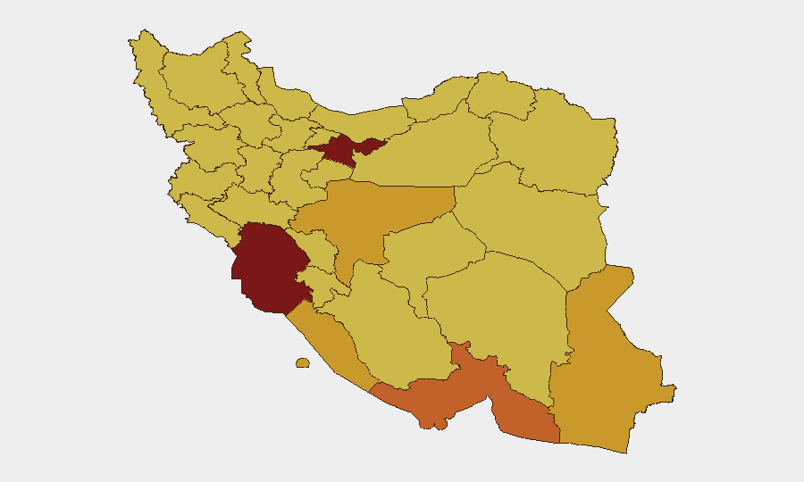
Situation Summary
Iran faces an acute and escalating security crisis following 13 consecutive nights of U.S. airstrikes targeting military infrastructure across multiple provinces. Simultaneous Iranian retaliatory drone launches toward U.S. bases in Jordan and Bahrain, coupled with fresh Iranian threats against commercial shipping in the Strait of Hormuz, indicate active kinetic operations and reduced diplomatic restraint. Major foreign missions, including the UK Embassy, are withdrawing non-essential personnel from Tehran, signaling elevated risk perception among international stakeholders. The composite threat score of 98 and 1,063 tracked events reflect a rapidly destabilizing environment with high potential for further escalation.
Key Developments
- Khuzestan Province (Ahvaz), July 23–24: U.S. airstrikes struck multiple locations in Khuzestan, killing at least four people and damaging military installations across the province, part of the ongoing 13-night campaign.
- Bandar Abbas, Hormozgan Province, July 23–24: U.S. air and missile strikes targeted military and drone-storage facilities, causing widespread explosions and damage to command centers and strategic positions.
- Qeshm Island, Strait of Hormuz, July 23–24: U.S. strikes hit Qeshm Island facilities linked to Iran's maritime operations and military posture in the strategic waterway.
- Inland Provinces (Markazi, Lorestan, Yazd, Isfahan, Fars), July 23–24: A broader wave of U.S. attacks struck military sites across central and southern inland provinces, expanding the geographic scope of operations beyond coastal targets.
- Iranian Retaliatory Drone Operations, July 23–24: Iran's army announced launch of drones from Iranian territory toward U.S. bases in Jordan and Bahrain in direct response to ongoing U.S. strikes, indicating active cross-border retaliation.
- UK Embassy Drawdown, Tehran, July 23–24: The UK Embassy temporarily withdrew non-essential staff, citing security concerns tied to Trump's public threats to strike Iranian infrastructure if vessels are targeted in the Strait of Hormuz.
- Iranian Maritime Threats, July 23–24: Iranian authorities issued fresh warnings of "forceful response" against vessels deviating from approved Hormuz routing, coinciding with U.S. operations aimed at maintaining open shipping lanes.
Highest-Risk Areas
Tehran Province (98.2) leads the sub-national ranking, reflecting both ongoing military strikes on surrounding infrastructure and diplomatic volatility in the capital, where foreign missions are reducing staff presence. Khuzestan (81.1), Hormozgan (73), and Isfahan (72.2) provinces form a secondary cluster of elevated risk, driven by active U.S. military operations, drone-storage facilities, and command infrastructure concentrated in these regions. Coastal and maritime zones—particularly Bandar Abbas and Qeshm Island—face compounded risk from both kinetic strikes and the threat environment surrounding Strait of Hormuz commercial shipping operations. The concentration of military targets and retaliatory capability across southern and central Iran explains why nine of the twelve highest-risk provinces lie south of the Alborz range.
How GeoBit Would Assist
Corporate security teams should deploy AOI Monitoring & Early Warning on Tehran, Khuzestan, Hormozgan, and Isfahan provinces to receive alerts on new strike activity and civilian-impact events in real time. Conflict & Military and Satellite & Imagery Analysis capabilities enable rapid assessment of damage to critical infrastructure and force posture changes, supporting duty-of-care decisions for personnel in affected regions. Maritime & Aviation Tracking combined with Routing & Network Analysis are essential for supply-chain and personnel-movement teams navigating the Strait of Hormuz and Iranian airspace under heightened intercept and threat-to-shipping conditions.
7-Day Outlook
U.S. strike operations are likely to continue at current intensity or escalate, with Iranian retaliatory drone and missile activity persisting in response. Risk to maritime traffic, foreign diplomatic presence, and civilian infrastructure in Tehran and Khuzestan provinces will remain acute. Indirect diplomatic channels appear strained; further escalation or localized incidents could trigger expanded regional involvement within 7–10 days.
Highest-Risk Areas — Ranked
| # | State / Region | Risk |
|---|---|---|
| 1 | Tehran Province | 98.2 |
| 2 | Khuzestan Province | 81.1 |
| 3 | Hormozgan Province | 73 |
| 4 | Isfahan Province | 72.2 |
| 5 | Sistan and Baluchestan Province | 71.8 |
| 6 | Bushehr Province | 71.7 |
| 7 | East Azerbaijan Province | 70.6 |
| 8 | Fars Province | 70.5 |
| 9 | Kurdistan Province | 70.2 |
| 10 | Gilan Province | 69.5 |
| 11 | Zanjan Province | 69.4 |
| 12 | Ilam Province | 69.2 |
Sources
Previous Daily Briefs
A new Iran brief is written every day — each with its own risk map and downloadable CSV. Here's the last week; use the calendar to go further back.
📅 Browse every day by calendar →
Highlighted days have a brief. Tap a day for that day's map & analysis, or “csv” for that day's dataset ($5).
Atlas — our AI intelligence desk — emails them this snapshot personally. Nothing else, no list.