Situation Summary
Niger remains at composite threat rank #21 globally, with a nationwide score of 73. Open-source monitoring over the last 24–48 hours has not yielded any corroborated new incidents; the most recent clearly dated event (N'Guigmi attack, 31 July) falls outside the current reporting window. Structural risks—terrorism, armed group activity, kidnapping, and civil unrest—remain elevated across multiple regions, particularly in the northeast and along the Mali and Burkina Faso borders.
Key Developments
No new, corroborated security incidents have been reported in Niger within the last 24–48 hours according to open-source, regional media, and consular sources. All recent event signals logged in GeoBit's platform carry timestamps of 2 August but lack independent confirmation or detailed corroboration at this time. The most recent independently verified incident—the coordinated attack and ambush near N'Guigmi cemetery that killed at least 14 Nigerien Defence and Security Forces personnel—occurred on 31 July and therefore lies outside the current reporting cycle. Baseline threat activity (terrorism, armed group presence, trafficking) continues in Diffa, Agadez, Tillabéri, and border zones, but no fresh incidents have been pinned to the last 48 hours. Corporate and diplomatic personnel should monitor official channels (OSAC, State Department) for any real-time incident updates that may emerge later today.
Highest-Risk Areas
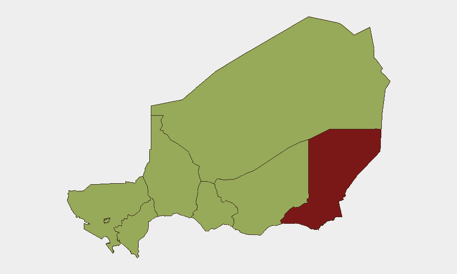
Diffa Region (risk score 80.8) is the clear outlier and primary concern, driven by sustained militant and armed-group activity, including links to ISGS and other transnational networks. Agadez, Zinder, Tillabéri, and Tahoua Regions all register at 50.8, reflecting chronic exposure to cross-border militant operations, trafficking networks, and periodic military engagements—particularly along the Mali–Burkina Faso frontier. Niamey itself (50.8) faces elevated crime, civil-unrest risk, and occasional armed-force confrontations. Risk levels remain significantly lower in the southern and central regions (Dosso, Maradi), though no zone is entirely insulated from national-level instability.
How GeoBit Would Assist
Security teams with personnel or assets in Niger should employ AOI Monitoring & Early Warning on Diffa, Agadez, Tillabéri, and border crossings to trigger alerts on fresh militant or military activity. Intel Sweep and multi-language OSINT feeds (including X/Twitter and regional media) provide continuous ingestion of incident reports, enabling 24-hour corroboration before escalation to duty officers. Conflict & Military mapping and force-structure tracking help teams understand armed-group disposition and military response capacity in high-risk zones, informing movement decisions and safe-house protocols.
7-Day Outlook
No major shift in the threat trajectory is anticipated in the next seven days absent a significant triggering event. Militant and criminal activity will likely persist at baseline levels across Diffa and the border regions; security forces will continue reactive operations. Any deterioration would probably be signaled by a cluster of incidents in 24–48 hours, making real-time monitoring essential for teams with operations in or transiting through the northeast.
Highest-Risk Areas — Ranked
| # | State / Region | Risk |
|---|---|---|
| 1 | Diffa Region | 80.8 |
| 2 | Agadez Region | 50.8 |
| 3 | Zinder Region | 50.8 |
| 4 | Tillabéri Region | 50.8 |
| 5 | Niamey | 50.8 |
| 6 | Tahoua Region | 50.8 |
| 7 | Dosso Region | 50.8 |
| 8 | Maradi Region | 50.8 |
Sources
Previous Daily Briefs
A new Niger brief is written every day — each with its own risk map and downloadable CSV. Here's the last week; use the calendar to go further back.
📅 Browse every day by calendar →
Highlighted days have a brief. Tap a day for that day's map & analysis, or “csv” for that day's dataset ($5).
Atlas — our AI intelligence desk — emails them this snapshot personally. Nothing else, no list.