Situation Summary
South Sudan remains fragmented across competing armed factions, intercommunal militias, and state security forces, with violence concentrated in the oil-rich north and pastoral belt (Unity, Jonglei, Upper Nile states). The week of 25–27 September saw multiple fatal intercommunal clashes and armed abductions; regional diplomatic pressure on 29 September reflects international concern over pre-election instability ahead of December polling. The security baseline remains volatile, with no indication of de-escalation in either organized or communal violence.
Key Developments
- 29 September, Mundri East County, Western Equatoria State (Lui–Lanyi Dawa road): Armed attackers ambushed passenger vehicles, abducting at least 27 civilians. Survivors reported beatings, torture, and rape; some abductees remained unaccounted for. Police deployed reinforced patrols along the Juba–Mundri corridor in response.
- 27 September, unspecified location, Western Equatoria State: Armed men intercepted vehicles returning from a funeral, killed five civilians attempting to flee, burned the vehicles, and abducted occupants.
- 27 September, unspecified location: Armed group opened fire on residents returning from honey-collection activities, killing 12 and wounding one; local authorities attributed the attack to broader resource-conflict tensions.
- 25 September, Duk and Twic East counties, Jonglei State: Intercommunal youth clashes over pastoral resources and grazing rights resulted in at least 13 deaths and 26 injured; fighting persisted throughout the day.
- 22 September, Boma sub-county, Jonglei State: Alleged SPLM/A-IO–aligned forces looted and abducted a Boma sub-chief and four youths; no fatalities reported.
- 29 September, Juba: The African Union's C5 mechanism and IGAD convened to review election readiness and security trajectories, expressing concern over deteriorating political cohesion among 2018 peace agreement signatories.
- 29 September, national level: Regional mediators called for immediate ceasefire and renewed compliance with the 2018 Revitalized Agreement, citing escalating armed confrontations between signatory factions.
- Late September, flood-prone areas: Heavy rainfall driven by El Niño conditions stressed temporary flood-control infrastructure; humanitarian funding shortages compounded displacement and livelihood risks.
Highest-Risk Areas
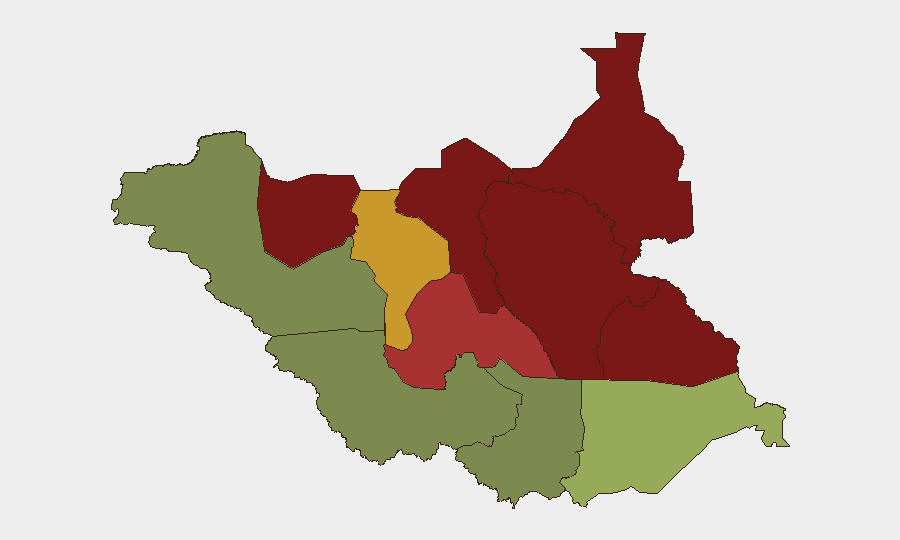
Unity, Jonglei, and Upper Nile states (risk scores 95, 93, and 88 respectively) dominate the threat landscape, driven by competition over oil resources, pastoral land, and state control among armed groups. Greater Pibor Administrative Area (87) and Northern Bahr el Ghazal (82) face similar intercommunal and factional pressures. The south-central belt (Central Equatoria, risk 35) and southwest (Western Bahr el Ghazal, risk 28) show substantially lower composite risk, though the 29 September Mundri incident demonstrates that Western Equatoria remains vulnerable to mobile armed actors targeting civilian movement.
How GeoBit Would Assist
Security teams monitoring South Sudan should employ AOI Monitoring & Early Warning on highest-risk counties (Duk, Twic East, Mundri East) to detect emerging violence signatures in real time. Routing & Network Analysis capability supports identification of safer transport corridors and identification of ambush-prone routes (e.g., Juba–Mundri). OSINT fusion across radio SIGINT, social media, and local-language reporting provides early tactical warning of communal tensions, abduction activity, and faction movement prior to escalation.
7-Day Outlook
The December election cycle will likely intensify factional posturing and resource competition, particularly in oil-producing states. Intercommunal violence in the pastoral belt typically peaks during transition seasons; current clashes in Jonglei and Western Equatoria suggest sustained friction through October. No imminent ceasefire or security-sector reform is anticipated, and humanitarian access constraints will remain acute.
Highest-Risk Areas — Ranked
| # | State / Region | Risk |
|---|---|---|
| 1 | Unity | 95 |
| 2 | Jonglei | 93 |
| 3 | Upper Nile | 88 |
| 4 | Greater Pibor Administrative Area | 87 |
| 5 | Northern Bahr el Ghazal | 82 |
| 6 | Lakes | 78 |
| 7 | Warrap | 72 |
| 8 | Ruweng Administrative Area | 68 |
| 9 | Eastern Equatoria | 52 |
| 10 | Western Equatoria | 38 |
| 11 | Central Equatoria | 35 |
| 12 | Western Bahr el Ghazal State | 28 |
Sources
Previous Weekly Briefs
A new South Sudan brief is written every Monday, covering the week — each with its own risk map and downloadable CSV. Use the calendar to go further back.
- September 28, 2026
- September 21, 2026
- September 14, 2026
- September 7, 2026
- September 1, 2026
- August 30, 2026
- August 28, 2026
📅 Browse past briefs by calendar →
Highlighted days have a brief. Tap a day for that day's map & analysis, or “csv” for that day's dataset ($5).
Atlas — our AI intelligence desk — emails them this snapshot personally. Nothing else, no list.