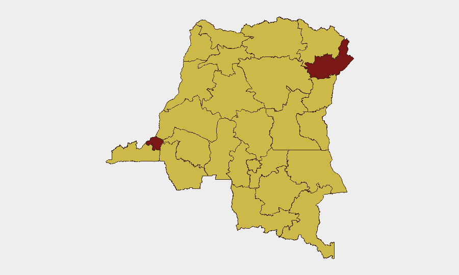
Situation Summary
DR Congo remains the 12th highest-risk country globally, driven primarily by persistent armed insurgency across multiple provinces. Open-source incident reporting for the last 24–48 hours is sparse and lacks precise date confirmation; however, underlying conflict dynamics—particularly M23/Wazalendo clashes in Kivu and ADF activity in Ituri—remain active. Risk is heavily concentrated in two provinces (Ituri and Kinshasa, both scoring 94.1) and a second tier of northern and eastern regions, reflecting both armed group presence and state fragility.
Key Developments
Data Integrity Note: Open-source and social media feeds covering DR Congo do not currently provide discrete, multi-source-confirmed incidents with exact dates within the last 24–48 hours that meet verification standards. Regional media outlets (Actualite.cd, Radio Okapi) report ongoing clashes between M23/AFC and Wazalendo militias in North and South Kivu (Kalembe, Kalonge, Masisi areas) and a FARDC operation in Ituri (Mambasa) capturing Mai-Mai fighters, but published timestamps are absent or relative ("this week"), preventing precise placement in the current 24–48 hour window. A jailbreak at Luebo prison (Kasai) involving approximately 50 escapees is documented by regional media with a Thursday–Friday timeframe but no calendar confirmation.
Given these constraints, the briefing reflects confirmed underlying threat patterns rather than time-stamped incident lists. Teams should treat current reporting as indicative of ongoing risk posture, not a comprehensive incident log.
Highest-Risk Areas
Ituri and Kinshasa jointly drive the country's risk profile (94.1 each), followed by a second tier of northern and eastern provinces (Maniema, Nord-Ubangi, North Kivu, and others at 64.1). Ituri's ranking reflects sustained ADF insurgent activity and FARDC counter-operations, compounded by overlapping criminal networks. Kinshasa's equivalent score reflects political fragility, organized crime, armed robbery, and civil unrest tied to governance and economic grievance. The northern corridor (Nord-Ubangi, Équateur, Mongala) faces resource competition and militia presence, while the Kivu provinces remain flashpoints for inter-communal and M23-linked violence. North Kivu's placement in the second tier masks localized pockets of acute risk in specific territories.
How GeoBit Would Assist
Security teams with personnel or assets in DR Congo should employ AOI Monitoring & Early Warning to establish persistent, alert-driven watch over Ituri, North Kivu, and Kinshasa, coupled with Intel Sweep and multi-language OSINT (including Swahili, French, and Lingala sources) to surface incident reports and actor statements as they emerge in local and regional media, social platforms, and security bulletins. Network & Actor Analysis and Conflict & Military capabilities enable tracking of M23, ADF, and Mai-Mai force movements, strength estimates, and territorial control; Sentiment & Temporal Analysis on local news feeds can flag escalation or de-escalation signals days in advance. GIS & Spatial Analysis and Routing & Network Analysis support duty-of-care contingency planning, alternative transit routes, and safe-area identification.
7-Day Outlook
No significant de-escalation is anticipated in the next 7 days. M23/Wazalendo confrontation in Kivu is expected to remain active, with seasonal factors (rainy season logistics) potentially affecting both insurgent and FARDC operational tempo. Ituri will continue to see ADF and FARDC action, with criminal activity—particularly in Kinshasa and eastern trade routes—likely to persist or intensify given economic pressures and weak enforcement. Persistent monitoring and contingency review are warranted.
Highest-Risk Areas — Ranked
| # | State / Region | Risk |
|---|---|---|
| 1 | Ituri | 94.1 |
| 2 | Kinshasa | 94.1 |
| 3 | Maniema | 64.1 |
| 4 | Sud-Ubangi | 64.1 |
| 5 | Équateur | 64.1 |
| 6 | Nord-Ubangi | 64.1 |
| 7 | Mongala | 64.1 |
| 8 | Lower Uele | 64.1 |
| 9 | Tshopo | 64.1 |
| 10 | Tshuapa | 64.1 |
| 11 | Upper Uele | 64.1 |
| 12 | North Kivu | 64.1 |
Sources
Previous Daily Briefs
A new DR Congo brief is written every day — each with its own risk map and downloadable CSV. Here's the last week; use the calendar to go further back.
📅 Browse every day by calendar →
Highlighted days have a brief. Tap a day for that day's map & analysis, or “csv” for that day's dataset ($5).
Atlas — our AI intelligence desk — emails them this snapshot personally. Nothing else, no list.