Situation Summary
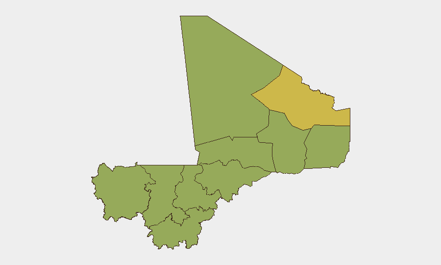
Mali remains at elevated risk (composite threat score 70, rank #18 globally), driven primarily by ongoing insurgency and armed-group activity across the Sahel. The conflict landscape is characterized by fragmentation across multiple regions, with Bamako (risk 79.1) standing out as the single highest-risk location due to political instability, military factional tensions, and security-force dynamics. No verified new security incidents have been confirmed in Mali over the past 24–48 hours (30–31 July 2026), though underlying structural drivers—irregular military activity, external military partnerships, and human rights concerns—remain acute.
Key Developments
- Bamako (1 August 2026): Multiple public statements, military-to-military tensions, and allegations of rights violations by external actors indicate sustained political and security friction within capital institutions; no discrete attack or arrest confirmed in the past 48 hours.
- Mali–Ukraine Relations (1 August 2026): Diplomatic downgrade signaled, reflecting broader geopolitical realignment and potential shifts in external military support posture relevant to counterinsurgency capacity.
- Kidal & Northern Regions (ongoing, context since mid-July): Tuareg separatist and militant groups continue conventional operations against Malian and Russian-aligned forces; no new verified clash location or date in past 48 hours, but sustained contact pattern.
- Mopti Region (reference incident 15 June 2026, reported 31 July): Human Rights Watch documented airstrike casualty allegations; included for awareness of civilian-harm trajectory in high-risk zone, though incident falls outside 48-hour window.
- Countrywide (30–31 July): Security monitoring networks report absence of independently verified attacks, armed clashes, major arrests, or infrastructure damage; absence of incident does not imply reduced threat posture.
Highest-Risk Areas
Bamako's dominance (79.1) reflects capital-level political turbulence, internal military factionalism, and security-force friction—distinct from battlefield insurgency. The northern tier—Kidal (62.8), Gao, Timbuktu, and Ménaka—faces ongoing separatist and militant activity, though risk scores cluster at 49.1 across most non-capital regions, indicating distributed but not uniformly intense pressure. Mopti (49.4) edges higher, likely due to civilian-harm events and militant penetration. The concentration of risk in Bamako versus dispersed but sustained threat in the north suggests dual vulnerability: state-level instability in the capital and ungoverned-space insurgency across the Sahel corridor.
How GeoBit Would Assist
Teams with people or assets in Mali should leverage GeoBit's AOI Monitoring & Early Warning to establish persistent watch on Bamako institutions and northern flashpoints (Kidal, Mopti, Gao), with alert thresholds tuned to military movement, checkpoint activity, and armed-group communication. Intel Sweep and OSINT fusion (X/Twitter, Telegram, local media, cross-check protocols) provide daily incident verification and filtering to isolate confirmed events from rumor. Network & Actor Analysis and force-structure tracking clarify military-faction alignments and external-force posture (Russian, Ukrainian, separatist), informing duty-of-care decisions and movement planning.
7-Day Outlook
No immediate incident spike is forecast for the next 7 days based on current event density and tactical pause in verified activity. However, diplomatic friction (Mali–Ukraine downgrade, rights-group tensions with external military partners) and internal military factionalism create low-predictability flash points, particularly in or near Bamako. Sustained northern insurgency and seasonal patterns suggest elevated but not acute risk through mid-August; security teams should maintain heightened situational awareness and contingency protocols in Bamako and avoid unnecessary movement in Kidal, Gao, and Mopti regions.
Highest-Risk Areas — Ranked
| # | State / Region | Risk |
|---|---|---|
| 1 | Bamako | 79.1 |
| 2 | Kidal | 62.8 |
| 3 | Mopti | 49.4 |
| 4 | Ménaka | 49.1 |
| 5 | Kayes | 49.1 |
| 6 | Taoudénit Region | 49.1 |
| 7 | Gao | 49.1 |
| 8 | Koulikoro | 49.1 |
| 9 | Ségou Region | 49.1 |
| 10 | Sikasso Region | 49.1 |
| 11 | Timbuktu | 49.1 |
Sources
Previous Daily Briefs
A new Mali brief is written every day — each with its own risk map and downloadable CSV. Here's the last week; use the calendar to go further back.
📅 Browse every day by calendar →
Highlighted days have a brief. Tap a day for that day's map & analysis, or “csv” for that day's dataset ($5).
Atlas — our AI intelligence desk — emails them this snapshot personally. Nothing else, no list.