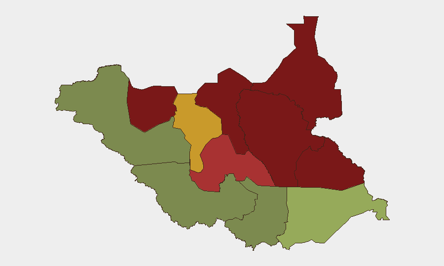
Situation Summary
South Sudan remains gripped by active armed conflict and intercommunal violence, with composite national threat score of 65 (#32 globally). The past week recorded four independently confirmed security incidents across Jonglei, Warrap, Western Equatoria, and Lakes states, resulting in at least 24 deaths and 51 wounded, plus the evacuation of 17 humanitarian workers. Risk is heavily concentrated in the oil-producing north and pastoral northeast—Unity, Jonglei, and Upper Nile states—where armed-youth mobilization, communal revenge cycles, and battles between state and non-state actors show no signs of de-escalation.
Key Developments
- 13 October, Wiechjol, Akobo County, Jonglei State: Intercommunal fighting between two clans escalated to involve seven clans; six killed and 17 wounded according to army spokesperson and Eye Radio.
- 12–13 October, Tonj East County, Warrap State: Fighting in Ngap Agok and Malual Chum payams killed at least 16 people and wounded 34, with retaliatory attacks on Thiik residential areas reported by county officials.
- 13 October, Bari military outpost, Kotobi Payam, Mundri West County, Western Equatoria State: Early-morning attack on SSPDF position wounded two soldiers. Army claimed to have repelled attackers; SPLA-IO claimed to have captured Bari Centre. Competing claims remain unverified.
- 13–19 October, Rumbek area, Lakes State: Following earlier clashes (8–9 October), UNMISS deployed quick-reaction force and convoy to Amok Payam to protect civilians and evacuated 17 humanitarian workers in response to renewed violence.
Highest-Risk Areas
Unity, Jonglei, and Upper Nile states dominate the risk landscape, each with composite scores of 95, 93, and 88 respectively. These three states are centers of oil infrastructure, pastoral resource competition, and active armed-group presence; Unity and Jonglei have experienced sustained intercommunal violence and youth mobilization throughout October. Greater Pibor Administrative Area (risk 87) and Northern Bahr el Ghazal (risk 82) pose similar threats driven by competition for cattle and grazing rights, and by the presence of armed-youth networks difficult to control by weak state institutions. By contrast, Central Equatoria (risk 35) and Western Bahr el Ghazal (risk 28)—both closer to the capital Juba—remain significantly more stable, though not incident-free.
How GeoBit Would Assist
Corporate security teams should employ AOI (area-of-interest) Monitoring & Early Warning on highest-risk counties in Unity and Jonglei to detect mobilization patterns and clashes before they affect supply chains or personnel movements. Conflict & Military analysis—including force-structure and weapons-capability tracking—provides situational awareness of armed actors and their operational reach, enabling duty-of-care teams to forecast spillover into adjacent counties and adjust travel routes via Routing & Network Analysis. Real-time Intel Sweep and global event feeds, combined with multi-language OSINT from local radio and community networks, offer the fastest independent verification of incidents and casualty figures, reducing reliance on official statements that frequently conflict.
7-Day Outlook
Intercommunal violence in pastoral zones (Jonglei, Warrap, Akobo) is likely to persist through the coming week given unresolved revenge cycles and the absence of functional dispute-resolution mechanisms. The cross-border incident of 17 October—in which South Sudanese armed men killed ~140 civilians in Ethiopia—may trigger Ethiopian security responses that could spill back into Upper Nile or Unity states. Risk of humanitarian access disruption and staff evacuation in Lakes and northern Equatoria remains elevated.
Highest-Risk Areas — Ranked
| # | State / Region | Risk |
|---|---|---|
| 1 | Unity | 95 |
| 2 | Jonglei | 93 |
| 3 | Upper Nile | 88 |
| 4 | Greater Pibor Administrative Area | 87 |
| 5 | Northern Bahr el Ghazal | 82 |
| 6 | Lakes | 78 |
| 7 | Warrap | 72 |
| 8 | Ruweng Administrative Area | 68 |
| 9 | Eastern Equatoria | 52 |
| 10 | Western Equatoria | 38 |
| 11 | Central Equatoria | 35 |
| 12 | Western Bahr el Ghazal State | 28 |
Sources
Previous Weekly Briefs
A new South Sudan brief is written every Monday, covering the week — each with its own risk map and downloadable CSV. Use the calendar to go further back.
- October 12, 2026
- October 5, 2026
- September 28, 2026
- September 21, 2026
- September 14, 2026
- September 7, 2026
- September 1, 2026
📅 Browse past briefs by calendar →
Highlighted days have a brief. Tap a day for that day's map & analysis, or “csv” for that day's dataset ($5).
Atlas — our AI intelligence desk — emails them this snapshot personally. Nothing else, no list.