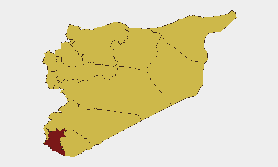
Situation Summary
Syria remains the eighth-highest-threat country globally (composite score 96), driven by active civil conflict across multiple governorates. The most acute violence is concentrated in coastal provinces—particularly Latakia—where pro-Assad insurgent groups have escalated ambushes, infrastructure attacks, and clashes with security forces over the past 48 hours. Damascus Governorate maintains the highest sub-national risk score (96.9), reflecting the capital's exposure to state fragmentation, while a secondary tier of governorates (Dar'a, coastal belt, northern regions) report sustained armed activity and sectarian tensions.
Key Developments
- Latakia coastal corridor (July 30–31): Armed pro-Assad groups conducted sustained hit-and-run ambushes on highways serving Latakia, Jabla, and Baniyas, targeting security vehicles and disrupting civilian traffic. Multiple sources confirm over 200 security casualties and at least 1,000 total fatalities reported by monitoring organizations over the latest fighting cycle.
- Latakia power and utilities infrastructure (July 31): Pro-Assad insurgents attacked a major power station, water-pumping facilities, and fuel depots in the coastal province, causing cascading outages in electricity and water supply across parts of Latakia Governorate and complicating logistics for all transport modes.
- Latakia–Jabla–Baniyas search operations (July 31): Syrian security sources report ongoing search-and-sweep operations targeting an estimated 5,000 armed pro-Assad fighters sheltering in mountainous terrain, indicating sustained instability in rural approaches and access roads to coastal towns.
- Coastal checkpoints and movement restrictions (July 31): Intensified security patrols and clashes have generated widespread roadblocks and checkpoint activity, creating unpredictable delays and access restrictions for civilian and commercial movement through the coastal belt.
- Saudi–Syria military activity (July 31): Open-source signals indicate conventional military force deployments and statements between Saudi Arabia and Syria, though full operational context and scale remain unclear from available reporting.
- Israel–Syria resident threat activity (July 31): Israeli military statements referencing threats to residents and administrative sanctions on civilian populations were recorded, indicating continued cross-border tension and potential civilian-protection risks in southern/southwestern border zones.
Highest-Risk Areas
Damascus Governorate dominates the sub-national ranking (96.9) due to concentration of state institutions, security-force presence, and proximity to inter-communal fault lines. The second-tier cluster—Dar'a (82.4) and the coastal belt (Latakia, Tartus, 66.9 each)—reflects active armed groups, infrastructure targeting, and highway ambush activity. Idleb, Aleppo, Hama, Ar-Raqqa, Homs, and Rif Dimashq remain elevated (66.9) owing to fragmented control, unresolved sectarian tensions, and ongoing low-intensity conflict. The UNDOF zone (66.9) reflects ceasefire fragility and cross-border spillover risk.
How GeoBit Would Assist
Teams with personnel or assets in Syria should deploy AOI Monitoring & Early Warning to track Latakia, Damascus, and Dar'a with persistent alerting for clashes, infrastructure damage, and checkpoint activity. Routing & Network Analysis is critical to identify safe alternative routes around ambush corridors on coastal highways and to Aleppo. Conflict & Military tracking (force structure, weapons capability, battle mapping) combined with Network & Actor Analysis will clarify Saudi-Syrian military posture and pro-Assad insurgent disposition.
7-Day Outlook
The pace of coastal fighting is reported as slowing, but security-force search operations and armed-group presence suggest instability will persist through early August. Infrastructure damage to power and water systems will compound humanitarian stress and create secondary logistical risks. Cross-border military signals (Saudi, Israeli) may escalate or remain rhetorical; continued monitoring of official statements and force movements is essential for early warning.
Highest-Risk Areas — Ranked
| # | State / Region | Risk |
|---|---|---|
| 1 | Damascus Governorate | 96.9 |
| 2 | Dar'a Governorate | 82.4 |
| 3 | Lattakia Governorate | 66.9 |
| 4 | Tartus Governorate | 66.9 |
| 5 | UNDOF | 66.9 |
| 6 | Al-Quneitra Governorate | 66.9 |
| 7 | Idleb Governorate | 66.9 |
| 8 | Aleppo Governorate | 66.9 |
| 9 | Hama Governorate | 66.9 |
| 10 | Ar-Raqqa Governorate | 66.9 |
| 11 | Homs Governorate | 66.9 |
| 12 | Rif Dimashq Governorate | 66.9 |
Sources
Previous Daily Briefs
A new Syria brief is written every day — each with its own risk map and downloadable CSV. Here's the last week; use the calendar to go further back.
📅 Browse every day by calendar →
Highlighted days have a brief. Tap a day for that day's map & analysis, or “csv” for that day's dataset ($5).
Atlas — our AI intelligence desk — emails them this snapshot personally. Nothing else, no list.