Situation Summary
Iran is experiencing active large-scale military conflict with the United States, marked by reciprocal airstrikes, drone attacks, and reported involvement of regional proxies. Concurrently, critical infrastructure (banking, transport) is experiencing disruptions, bread prices in Tehran have doubled, and hardline political actors are escalating rhetoric against government negotiators, signaling internal regime fracture. The combination of kinetic operations, economic strain, and political instability creates compound risk across commercial operations, supply chains, and personnel safety nationwide.
Key Developments
- Iranian drone strikes on Kuwait bases (26–27 July): Iran's Army conducted large-scale drone attacks on US ammunition, logistics, and fuel storage at three bases in Kuwait, described as retaliatory operations against US forces in the region.
- Ongoing US airstrikes in southern and central Iran (through 26 July, day 12): Explosions reported in Bandar Abbas, Ahvaz, Qeshm Island, and multiple provinces (Markazi, Lorestan, Yazd, Isfahan, Fars); US Central Command states strikes target military sites and drone facilities to "degrade Iran's ability to threaten civilian mariners."
- Civilian infrastructure damage reported (25–26 July): US strikes on railway bridges and unspecified civilian targets in Iran have resulted in at least 14 deaths and 78 injuries according to Iranian health ministry; heightened risk to transport logistics and personnel movement.
- Explosions near Bandar Mahshahr, Khuzestan (24–26 July): Tasnim News Agency reported blasts in southwestern Iran consistent with ongoing US–Iran military operations.
- Nationwide banking outages (reported this week): At least eight Iranian banks experienced major electronic and card-services failures, disrupting commerce and travel-related payments; follows earlier four-bank outage.
- Bread price surge in Tehran Province (current week): Prices up to 100%, triggering civil-unrest risk and subsidy-reform concerns amid war-related economic stress.
- Hardline political backlash in Tehran (past several days): Public death chants against chief negotiators Abbas Araghchi and Mohammad Bagher Ghalibaf following US–Iran ceasefire memorandum announcement; signals intra-regime tension and potential protest/repression risk near political venues.
- Security force violence in Sistan and Baluchestan (ongoing conflict period): Baluch women beaten during protests against mining projects; reflects continued heavy-handed minority policing and elevated travel/human-rights risk in southeastern provinces.
Highest-Risk Areas
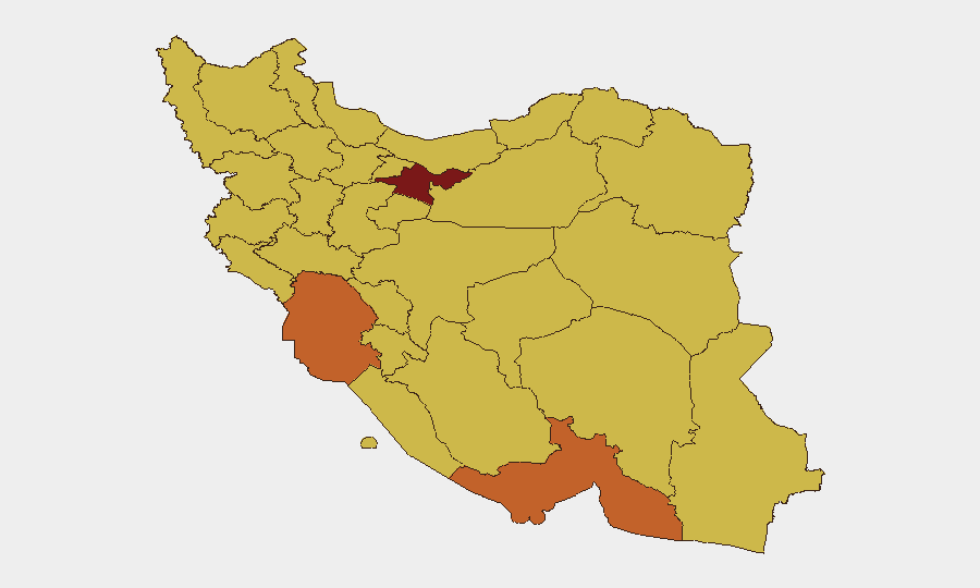
Tehran Province remains the highest-risk location (98.3) due to political sensitivity, government concentration, and civilian infrastructure targeting. The southern maritime corridor—Hormozgan (75.1), Khuzestan (74.4), and Bushehr (70.1)—faces direct military strike risk from ongoing US airstrikes targeting military and drone facilities near the Strait of Hormuz. Central provinces including Isfahan (69.7), Yazd (69.1), and Kerman (69.1) report active strikes on military infrastructure. Minority-populated areas, particularly Sistan and Baluchestan (68.7) and Kurdistan (69.3), face dual risk from security-force repression and regional military operations.
How GeoBit Would Assist
Teams should deploy AOI Monitoring & Early Warning on personnel locations and asset concentrations in Tehran, Khuzestan, and southern ports to receive real-time alerts on strikes and infrastructure damage. Conflict & Military mapping and force-structure tracking would clarify active strike zones and allow dynamic rerouting via Routing & Network Analysis to avoid transport chokepoints. Economic & Trade monitoring combined with OSINT fusion on banking status and fuel availability would enable duty-of-care assessment and supply-chain contingency planning.
7-Day Outlook
Airstrikes are likely to continue in the short term, with emphasis on southern Iran and maritime chokepoints. Political tension over ceasefire negotiations may trigger localized protests or security crackdowns in Tehran and minority regions. Banking and civilian infrastructure disruptions are expected to persist, compounding logistics and payment risks for corporate operations.
Highest-Risk Areas — Ranked
| # | State / Region | Risk |
|---|---|---|
| 1 | Tehran Province | 98.3 |
| 2 | Hormozgan Province | 75.1 |
| 3 | Khuzestan Province | 74.4 |
| 4 | Bushehr Province | 70.1 |
| 5 | Isfahan Province | 69.7 |
| 6 | Kurdistan Province | 69.3 |
| 7 | Yazd Province | 69.1 |
| 8 | Kerman Province | 69.1 |
| 9 | Sistan and Baluchestan Province | 68.7 |
| 10 | Razavi Khorasan | 68.6 |
| 11 | Kermanshah Province | 68.5 |
| 12 | Fars Province | 68.4 |
Sources
Previous Daily Briefs
A new Iran brief is written every day — each with its own risk map and downloadable CSV. Here's the last week; use the calendar to go further back.
📅 Browse every day by calendar →
Highlighted days have a brief. Tap a day for that day's map & analysis, or “csv” for that day's dataset ($5).
Atlas — our AI intelligence desk — emails them this snapshot personally. Nothing else, no list.