Situation Summary
Niger remains ranked #21 globally by composite threat score (66/100), with elevated conventional military activity and localized insurgent operations concentrated in the north and east. The most significant recent incident—a Boko Haram–attributed attack near N'Guigmi on 31 July resulting in 14–17 Nigerien security force casualties—continues to drive security posture across Diffa Region, the country's highest-risk zone. Open-source reporting confirms no new discrete security incidents in Niger over the 24–48 hours preceding 3 August; however, structural vulnerabilities in border regions and elevated operational tempo among armed groups persist.
Key Developments
No corroborated new security incidents meeting the 24–48-hour criterion were identified in available open-source channels as of 3 August 2026. GeoBit's latest country-level security update explicitly records the absence of newly reported attacks, protests, kidnappings, or infrastructure disruptions in this window. Persistent risk signals continue to emanate from Diffa Region's border corridor with Nigeria and Chad, where non-state armed group activity remains elevated following the late-July N'Guigmi engagement. National Guard and Nigerien Armed Forces (FAN) continue heightened patrol and response postures in northern Agadez, Tillabéri, and Tahoua regions, though no new clash reports are confirmed. Media reporting remains focused on consequences and security response to the 31 July N'Guigmi attack, rather than new incidents.
Highest-Risk Areas
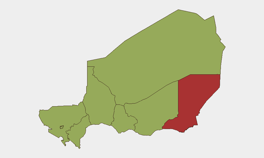
Diffa Region (risk score 76.1) stands isolated as Niger's primary threat concentration, driven by active Boko Haram and Islamic State West Africa Province (ISWAP) operational zones, porous borders with Nigeria and Chad, and recurring attacks on security infrastructure. All other seven regions cluster at identical risk scores (46.1), indicating distributed but secondary vulnerability across Agadez, Zinder, Tillabéri, Tahoua, Dosso, Maradi, and the capital Niamey. Border zones—particularly the Nigerian frontier in Diffa and the Mali/Burkina Faso interface in Tillabéri—remain principal corridors for cross-border militant movement and trafficking. Niamey's inclusion at the regional median reflects capital-city political risk (media–security force tensions noted in event signals) and presence of foreign nationals and critical infrastructure.
How GeoBit Would Assist
Security teams should employ AOI Monitoring & Early Warning on Diffa's N'Guigmi district, Agadez border crossings, and Niamey's key installations to detect emerging activity before escalation. OSINT fusion and multi-language media scanning across Cridem, local press, and Telegram/X feeds will corroborate incident reports and clarify actor intentions faster than single-source reliance. Conflict mapping and force-structure tracking will maintain visibility on FAN and National Guard disposition changes, readiness status, and response timelines—critical for duty-of-care planning around personnel or asset movements near security operations.
7-Day Outlook
Diffa Region will likely remain under heightened security operations for 7–10 days as FAN consolidates response to the 31 July N'Guigmi attack and reasserts control of perimeter installations. Cross-border activity (Nigeria, Chad) carries persistent but not imminent escalation risk; no major coordinated offensive is currently signaled. Corporate security should maintain elevated vigilance for checkpoint delays, sporadic curfews, and movement restrictions in northern regions, while monitoring Niamey's political environment for secondary impacts on permit or visa processing.
Highest-Risk Areas — Ranked
| # | State / Region | Risk |
|---|---|---|
| 1 | Diffa Region | 76.1 |
| 2 | Agadez Region | 46.1 |
| 3 | Zinder Region | 46.1 |
| 4 | Tillabéri Region | 46.1 |
| 5 | Niamey | 46.1 |
| 6 | Tahoua Region | 46.1 |
| 7 | Dosso Region | 46.1 |
| 8 | Maradi Region | 46.1 |
Sources
Previous Daily Briefs
A new Niger brief is written every day — each with its own risk map and downloadable CSV. Here's the last week; use the calendar to go further back.
📅 Browse every day by calendar →
Highlighted days have a brief. Tap a day for that day's map & analysis, or “csv” for that day's dataset ($5).
Atlas — our AI intelligence desk — emails them this snapshot personally. Nothing else, no list.