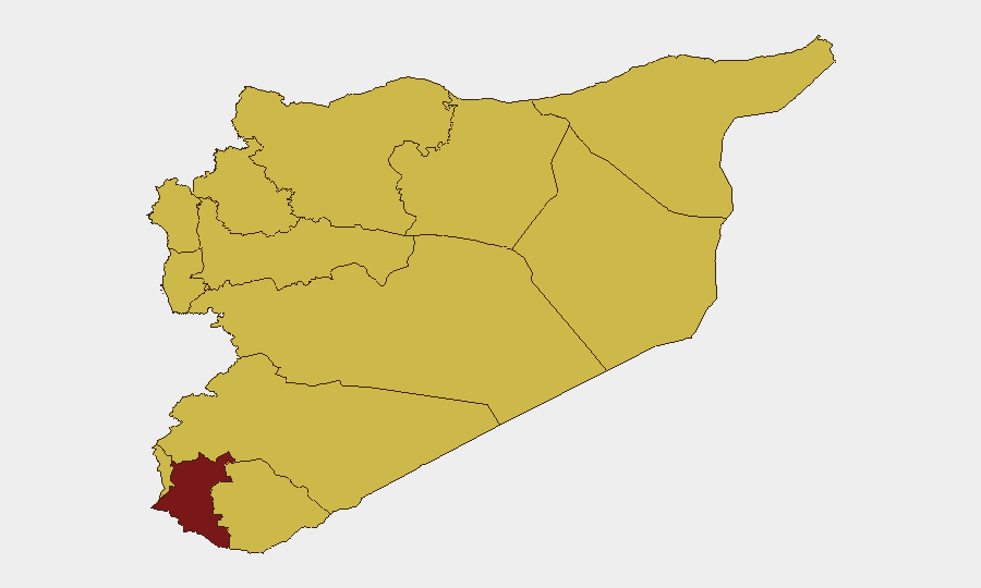
Situation Summary
Syria remains the eighth-highest threat environment globally, driven by ongoing civil war and the fragmentation of state control across multiple governorates. Damascus Governorate exhibits the highest composite risk (97.1), reflecting concentrated political, military, and administrative instability in the capital. Regional actors—including Turkish, Saudi, and Israeli forces—continue military operations and threats against Syrian territory and residents, compounding volatility. The risk trajectory remains elevated with no near-term indicators of de-escalation.
Key Developments
Data Constraint Notice: Open-source verification of discrete, time-stamped security incidents in Syria for 2026-08-01 to 2026-08-02 is currently unavailable. GeoBit's event feeds record multiple entries for 2026-07-30 and 2026-07-31—including public statements from Syrian and Turkish officials, conventional military exchanges between Syrian and Saudi forces, Israeli threats and small-arms combat with Syrian forces, and administrative sanctions against residents—but these entries lack sufficient granularity (specific locations, casualty counts, operational scope) for actionable inclusion in a duty-of-care brief. Satellite and open-source news reporting accessible to GeoBit platforms has not published confirmable incident details for the last 48 hours.
Recommended Action: Corporate security teams should rely on GeoBit's AOI Monitoring & Early Warning service (configured for Damascus, Dar'a, Idleb, and Aleppo governorates) to receive real-time alerting on attacks, military clashes, or administrative actions affecting personnel or assets. Live event feeds will be updated as incidents are verified and timestamped.
Highest-Risk Areas
Damascus Governorate (97.1) dominates the risk landscape due to its status as the seat of government and primary locus of state-security operations, military mobilization, and civilian contestation. Dar'a Governorate (82.6) ranks second, reflecting sustained cross-border pressure, armed-group activity, and Israeli military incursions. The remaining ten governorates cluster at 67.1, indicating widespread exposure to civil-war dynamics, irregular armed forces, and external military intervention (Turkish, Saudi, Israeli operations). The UNDOF-administered Golan sector (67.1) carries specific risk from Israeli-Syrian military exchanges and threats to civilian residents. Personnel or assets in or transiting Damascus require heightened duty-of-care protocols; operations in southern Dar'a and the Golan require sustained threat monitoring.
How GeoBit Would Assist
Intel Sweep & OSINT Fusion can consolidate multi-language open-source reporting, OSINT dashboards, social-media signals, and entity-extraction analysis to identify emerging threats earlier than traditional news cycles and to corroborate or dismiss unverified claims. Conflict & Military Battle Mapping, Force-Structure Tracking, and Weapons-Capability Assessments allow security teams to understand deployment patterns, escalation indicators, and potential flashpoints by faction and region. Persistent AOI Monitoring with geofenced alerting on Damascus, Dar'a, Idleb, Aleppo, and coastal governorates provides real-time notification of attacks, military movement, or administrative action affecting specific facilities or personnel, enabling rapid duty-of-care response (evacuation, sheltering, supply-chain rerouting).
7-Day Outlook
Military and political friction among Syrian, Turkish, Saudi, and Israeli actors will likely persist, with sporadic small-scale clashes and public rhetoric signaling no imminent ceasefire. Civilian access to utilities, movement, and administrative services in Damascus and secondary cities may experience further disruption. Risk of rapid escalation during this period remains moderate to high; any major military exchange or political crisis could accelerate forced displacement or facility evacuation.
Highest-Risk Areas — Ranked
| # | State / Region | Risk |
|---|---|---|
| 1 | Damascus Governorate | 97.1 |
| 2 | Dar'a Governorate | 82.6 |
| 3 | Lattakia Governorate | 67.1 |
| 4 | Tartus Governorate | 67.1 |
| 5 | UNDOF | 67.1 |
| 6 | Al-Quneitra Governorate | 67.1 |
| 7 | Idleb Governorate | 67.1 |
| 8 | Aleppo Governorate | 67.1 |
| 9 | Hama Governorate | 67.1 |
| 10 | Ar-Raqqa Governorate | 67.1 |
| 11 | Homs Governorate | 67.1 |
| 12 | Rif Dimashq Governorate | 67.1 |
Sources
Previous Daily Briefs
A new Syria brief is written every day — each with its own risk map and downloadable CSV. Here's the last week; use the calendar to go further back.
📅 Browse every day by calendar →
Highlighted days have a brief. Tap a day for that day's map & analysis, or “csv” for that day's dataset ($5).
Atlas — our AI intelligence desk — emails them this snapshot personally. Nothing else, no list.