Situation Summary
Central African Republic remains in a state of chronic structural insecurity driven by competing armed groups, state fragmentation, and limited government control outside Bangui. No time-stamped security or unrest incidents have been verified in open-source reporting for 3–5 August 2026, reflecting a significant data gap rather than improved conditions. Underlying threat trajectories remain elevated, particularly in the country's northern and eastern prefectures where non-state armed actors operate with minimal state or UN interference.
Key Developments
No discrete, time-stamped security incidents have been cross-verified in open-source reporting for the last 24–48 hours (3–5 August 2026). Recent reporting from late July and early August contains ambiguous or undated references to ongoing tensions in Bangui (magistrate independence disputes) and renewed MINUSCA security measures in Vakaga, but none meet the threshold of a clearly dated, specific incident within the reporting window.
For operational context, prior events (outside the 24–48h window) include:
- Vakaga NGO robbery (before 28 July): Humanitarian team intercepted and robbed on Birao–Tiringoulou road.
- Am-Dafok armed attack (30 June): FACA reported control restored after dawn assault; incident part of broader non-state coalition offensive.
- UN sanctions renewal (29–31 July, New York): Security Council unanimously renewed arms embargo and targeted sanctions on CAR armed groups and individuals through 31 July 2027.
Security teams should treat the current 48-hour reporting gap as a monitoring blind spot, not as evidence of reduced risk.
Highest-Risk Areas
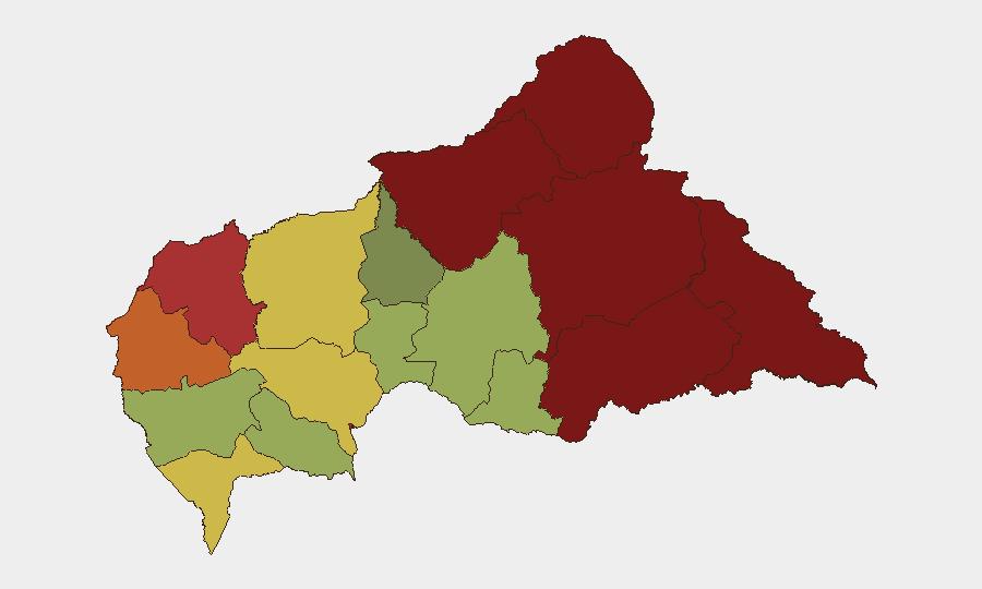
Vakaga Prefecture (risk score 95) and Bamingui-Bangoran (92) drive the country's threat profile, followed by Haute-Kotto (88) and Haut-Mbomou (85). These northern and eastern zones lie beyond effective state control and host multiple armed factions competing for territory and resources. Bangui itself (risk 78) remains volatile due to political tensions, criminal activity, and periodic FACA instability. The southern prefectures (Sangha-Mbaéré, Ouham, Ombella-M'Poko, Kémo) carry lower but still material risk, reflecting secondary supply routes and sporadic criminal activity. The gap between Vakaga (95) and Bangui (78) underscores the concentration of armed-group activity in the periphery and the capital's dual exposure to both political dysfunction and overflow conflict.
How GeoBit Would Assist
A security team with people or assets in CAR should deploy AOI Monitoring & Early Warning on Vakaga, Bamingui-Bangoran, and Bangui with persistent alerting on armed-group movements, FACA deployments, and civil unrest. Multi-language OSINT and social-media search (X, Telegram, local outlets) across 24–48h windows will help close reporting gaps and surface undated or locally-reported incidents before they propagate internationally. Network & Actor Analysis and conflict mapping capabilities support tracking of non-state coalition dynamics and MINUSCA operational posture, enabling duty-of-care teams to adjust travel routing and facility security in near-real time.
7-Day Outlook
No imminent escalation is signaled by available open-source intelligence, but the structural fragility of state authority and the perennial activity of armed groups in the north and east suggest that localized incidents (raids, clashes, criminal activity) remain probable. The UN sanctions renewal signals sustained international focus but does not materially alter ground dynamics. Organizations should assume persistent background insecurity in peripheral zones and maintain operational discipline on travel, information security, and personnel accountability.
Highest-Risk Areas — Ranked
| # | State / Region | Risk |
|---|---|---|
| 1 | Vakaga | 95 |
| 2 | Bamingui-Bangoran | 92 |
| 3 | Haute-Kotto | 88 |
| 4 | Haut-Mbomou | 85 |
| 5 | Mbomou | 82 |
| 6 | Ouham-Pendé | 79 |
| 7 | Bangui | 78 |
| 8 | Nana-Mambéré | 75 |
| 9 | Sangha-Mbaéré | 68 |
| 10 | Ouham | 65 |
| 11 | Ombella-M'Poko | 62 |
| 12 | Kémo | 58 |
Sources
Previous Daily Briefs
A new Central African Republic brief is written every day — each with its own risk map and downloadable CSV. Here's the last week; use the calendar to go further back.
📅 Browse every day by calendar →
Highlighted days have a brief. Tap a day for that day's map & analysis, or “csv” for that day's dataset ($5).
Atlas — our AI intelligence desk — emails them this snapshot personally. Nothing else, no list.