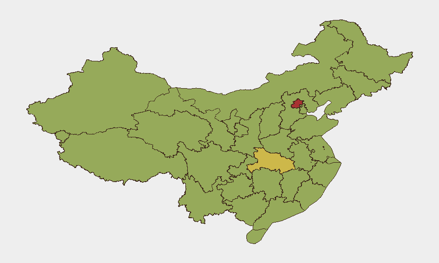
Situation Summary
China remains at moderate overall security risk (rank #21 globally, composite score 70) with a stable near-term outlook, though acute hazard-related incidents and weather disruptions are significantly impacting specific regions. The last 48 hours have seen multiple industrial, infrastructure, and natural-disaster incidents concentrated in eastern and central provinces, alongside ongoing geopolitical signalling and isolated cyber-crime activity. No major civil unrest or political instability has been reported, but cumulative transport, logistics, and safety impacts warrant heightened duty-of-care attention in affected areas.
Key Developments
- Jinjiang, Fujian Province (East China) – 30 July 2026: Fire at a shoe factory caused heavy casualties; President Xi ordered full search-and-rescue response, signalling central government prioritisation but also indicating serious incident scale and potential local regulatory crackdowns affecting business operations.
- Nanning, Guangxi (Southwest China) – 30–31 July 2026: City raised flood-control response to highest level as Typhoon Maysak drove river and reservoir overflow; significant disruption to urban transport, logistics, and utilities expected to persist through 31 July and beyond.
- Huludao, Liaoning (Northeast China) – 30 July 2026 (confirmed outcome): Residential building explosion killed three individuals initially reported missing; indicates ongoing urban infrastructure safety risks and likely heightened building inspections in the region.
- Sichuan Province (Southwest China) – 30 July 2026: 5.5-magnitude earthquake triggered Level-IV national emergency response for geological disasters; elevated landslide and aftershock risk in mountainous areas with potential disruption to remote transport and communications.
- Inner Mongolia (North China) – 30 July 2026: Truck explosion following collision killed two and injured four; reflects ongoing hazardous-materials and road-safety vulnerabilities on major freight routes.
- Hubei Province and wider central China – 28–31 July 2026: Thunderstorms and torrential rain killed at least eight people (28 July); severe-weather warnings continue through 31 July with elevated flood and landslide risk across multiple provinces.
- Hong Kong SAR – last 24–48 hours: Cyberattack on Shun Hing Group compromised data of approximately 1 million individuals; represents active targeting of major corporate IT infrastructure in the SAR.
- Hong Kong SAR – 30 July 2026: PLA Navy vessels *Nanning* and *Hengyang* entered Hong Kong waters; routine military presence with no reported unrest but relevant to security posture in the SAR.
Highest-Risk Areas
Beijing (#1, risk 78.9) and Hubei (#2, risk 60.7) drive the highest composite risk scores, though for distinct reasons. Beijing's ranking reflects concentrations of political activity, cyberattacks, and regulatory enforcement; Hubei's reflects the current severe-weather event cluster (eight fatalities, ongoing flooding, and landslide warnings through 31 July). Shanghai, Sichuan, and Tibet occupy positions 3–5, with Sichuan's earthquake response and ongoing aftershock risk now a near-term acute driver. Eastern coastal zones (Shanghai, Fujian, Zhejiang) face typhoon-related disruption and industrial-safety incident consequences, while southwestern and central regions face cascading natural-disaster risks.
How GeoBit Would Assist
Intel Sweep and OSINT Fusion can monitor evolving weather, emergency-response declarations, and infrastructure-safety updates in real time across Mandarin and English sources, enabling early detection of escalation or regional lockdowns affecting personnel. AOI Monitoring & Early Warning can maintain persistent watch on Fujian, Hubei, Sichuan, and Guangxi to alert duty-of-care teams to new incidents, aftershocks, or transport closures within hours. Routing & Network Analysis can generate alternative travel and supply-chain routes around active flood zones, typhoon paths, and areas under heightened inspection.
7-Day Outlook
Severe weather and typhoon impacts will likely persist through early August in southwestern and central provinces; flood and landslide risk remains elevated. Industrial-safety inspections and regulatory responses to the Jinjiang fire will intensify across manufacturing zones, potentially affecting permit approvals and site access. Overall stability is forecast to hold absent new major incidents, but travel, logistics, and operational timelines in affected regions should be reassessed daily.
Highest-Risk Areas — Ranked
| # | State / Region | Risk |
|---|---|---|
| 1 | Beijing | 78.9 |
| 2 | Hubei | 60.7 |
| 3 | Shanghai | 53.5 |
| 4 | Sichuan | 53.3 |
| 5 | Tibet | 52.2 |
| 6 | Guangdong Province | 51.6 |
| 7 | Fujian | 50.5 |
| 8 | Anhui | 50 |
| 9 | Zhejiang | 50 |
| 10 | Hebei | 49.7 |
| 11 | Jilin | 49.4 |
| 12 | Jiangsu | 49.4 |
Sources
Previous Daily Briefs
A new China brief is written every day — each with its own risk map and downloadable CSV. Here's the last week; use the calendar to go further back.
📅 Browse every day by calendar →
Highlighted days have a brief. Tap a day for that day's map & analysis, or “csv” for that day's dataset ($5).
Atlas — our AI intelligence desk — emails them this snapshot personally. Nothing else, no list.