Situation Summary
Iran remains in active regional conflict with the United States and Israel, marked by a three-day lull in major kinetic operations as of 27 July 2026 following nearly two weeks of sustained strikes on Iranian military and infrastructure targets. While the pause in confirmed attacks reduces immediate bombardment risk, underlying conflict drivers remain unresolved and infrastructure damage across multiple provinces constrains normal operations and emergency response. Domestic civil unrest or crime reporting is heavily suppressed by state censorship and wartime information controls, obscuring the full security picture for personnel and assets in-country. The conflict trajectory remains volatile, with maritime chokepoints (Strait of Hormoz) and coastal provinces presenting elevated travel and operational risk even during the current tactical pause.
Key Developments
- Strait of Hormuz maritime warning (27 July): Iranian authorities have threatened "forceful response" against commercial vessels deviating from state-approved routing through the Strait, raising risk for shipping and civilian maritime transit even as no fresh attacks are confirmed in the past 72 hours.
- Three-day pause in confirmed attacks (as of 27 July): No new major US, Israeli, or Iranian strikes have been verified since approximately 24 July, suggesting a tactical lull rather than ceasefire; underlying military posture and air-defence networks remain active and tense.
- Commercial shipping traffic decline (Strait of Hormuz, 26–27 July): Passage through the Strait has contracted to three-week lows, indicating continued risk perception and reduced operational capacity for goods and fuel movement despite the absence of fresh incidents.
- Continued diplomatic messaging and military signalling (25–27 July): Recent public statements and conventional military posturing by Iran, the US, and regional actors reflect ongoing rhetorical and operational tension without new kinetic escalation in the 24–48 hour window.
Highest-Risk Areas
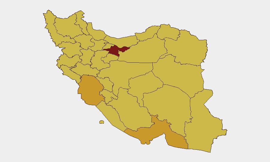
Tehran Province (risk 98) dominates the sub-national ranking, driven by its role as the political and administrative centre and presence of military command infrastructure targeted in the recent conflict phase. Khuzestan, Hormozgan, Bushehr, and Isfahan provinces (risk 69–71) remain elevated owing to proximity to the Strait of Hormuz, concentrations of energy infrastructure (refineries, ports, power generation), and reported earlier strike activity. Kerman, East Azerbaijan, Yazd, and Kermanshah provinces (risk 68–69) reflect secondary military and logistical nodes. The coastal and south-western corridor (Khuzestan, Hormozgan, Bushehr) presents compounded risk from maritime interdiction threats, reduced traffic, and prior damage to port and refinery facilities.
How GeoBit Would Assist
Teams with personnel or assets in Iran should deploy AOI Monitoring & Early Warning capabilities on Tehran Province and the Hormozgan–Bushehr coastal belt to detect resumption of kinetic activity or infrastructure incidents in real time. Maritime & Aviation Tracking combined with Routing & Network Analysis enable security teams to model alternative supply chains, verify safe passage corridors in the Strait, and monitor vessel movements around Iranian exclusion zones. Intel Sweep (multi-language OSINT fusion, X/Twitter & Telegram monitoring, and sentiment analysis) provides early detection of Iranian military signalling, censorship shifts, or civil-unrest indicators that open-source reporting suppresses.
7-Day Outlook
The three-day operational pause is unlikely to signal durable de-escalation; US and Iranian statements continue to signal readiness for renewed strikes. Expect continued maritime friction and routing restrictions in the Strait of Hormuz, with elevated risk if either side perceives the other preparing new operations. Infrastructure constraints (power, fuel, port access) will persist regardless of kinetic pause, affecting supply chains and emergency services across provincial nodes.
Highest-Risk Areas — Ranked
| # | State / Region | Risk |
|---|---|---|
| 1 | Tehran Province | 98 |
| 2 | Khuzestan Province | 71 |
| 3 | Hormozgan Province | 71 |
| 4 | Bushehr Province | 69.7 |
| 5 | Isfahan Province | 69.4 |
| 6 | Kerman Province | 69.2 |
| 7 | East Azerbaijan Province | 68.9 |
| 8 | Yazd Province | 68.9 |
| 9 | Razavi Khorasan | 68.5 |
| 10 | Sistan and Baluchestan Province | 68.5 |
| 11 | Kermanshah Province | 68.3 |
| 12 | Zanjan Province | 68.3 |
Sources
Previous Daily Briefs
A new Iran brief is written every day — each with its own risk map and downloadable CSV. Here's the last week; use the calendar to go further back.
📅 Browse every day by calendar →
Highlighted days have a brief. Tap a day for that day's map & analysis, or “csv” for that day's dataset ($5).
Atlas — our AI intelligence desk — emails them this snapshot personally. Nothing else, no list.