Situation Summary
Mali remains under a nationwide state of emergency with an extremely volatile security environment driven by active insurgency and counterinsurgency operations. The composite threat score of 68 (#18 globally) reflects sustained jihadist and Tuareg-linked armed group activity across northern and central regions, though no verified incident-level attacks have been reported in the last 24–48 hours (as of 2026-08-03). Military operations, detention activity, and diplomatic tensions documented in early August appear to signal ongoing internal and geopolitical pressures rather than a sudden tactical escalation. The absence of new confirmed attacks does not reduce underlying volatility; curfews, roadblocks, and movement restrictions remain in effect countrywide.
Key Developments
- Mali–Rebellion Military Activity (2026-08-01): Conventional military operations reported as part of ongoing counterinsurgency. Specific locations and tactical details remain unconfirmed by independent sources; broader context indicates sustained army operations against armed groups.
- Malian Detention Events (2026-08-02): Multiple arrest/detainment actions reported involving prison and government actors. No verified incident details or locations released; signals internal security activity or potential civil unrest.
- International Diplomatic Rejection (2026-08-02, Ukraine–Mali): Ukrainian rejection of Malian position(s) reported; context unclear but suggests ongoing political friction between Bamako and Western/international actors—possibly related to Russia alignment or governance.
- Rights Group Disapproval (2026-08-01): International human rights organization public disapproval of Russian actors, likely in connection with reported private military company (PMC) involvement in Mali; reflects international criticism of security arrangements.
- Countrywide Security Posture (2026-08-01–02): Reporting confirms continuation of state-of-emergency measures (curfews, checkpoints, identity verification) but no new discrete attacks, clashes, or infrastructure damage verified in the last 48 hours across traditionally high-risk areas (Timbuktu, Gao, Ménaka, Mopti, Bamako).
Highest-Risk Areas
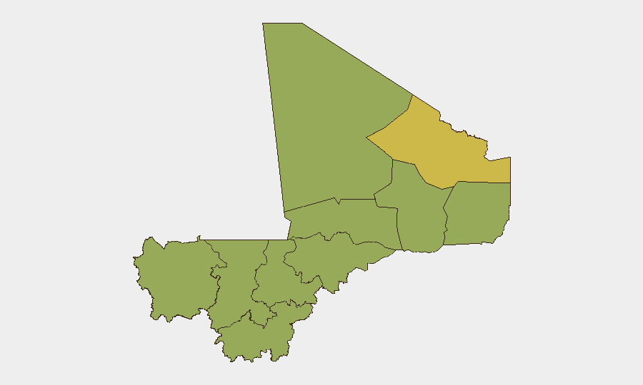
Bamako (77.8) significantly outpaces all other regions and reflects capital-city exposure to political instability, detention activity, and security-force operations. Kidal (66.3) remains a critical secondary hotspot, historically a Tuareg stronghold and ongoing insurgent sanctuary. The remaining nine regions cluster between 47.8–48.6, indicating a diffuse but persistent threat environment across Koulikoro, Mopti, Ménaka, Kayes, Taoudénit, Gao, Ségou, Sikasso, and Timbuktu. This distribution points to sustained insurgent presence across the Sahel belt and fragmented state control rather than localized instability.
How GeoBit Would Assist
Security and duty-of-care teams operating in Mali should deploy AOI Monitoring & Early Warning on high-risk zones (Bamako, Kidal, Mopti, Gao) to detect emerging clashes or military sweeps before they affect movement or operations. Conflict & Military analysis (force structure, weapons capability, battle mapping) and Network & Actor Analysis enable tracking of rebel group movements and splinter dynamics. Routing & Network Analysis supports real-time alternative journey planning and checkpoint avoidance; multi-language OSINT (X/Twitter, Telegram, local news feeds) provides day-of verification of curfew changes, roadblock locations, and detention sweeps that commercial travel platforms do not capture.
7-Day Outlook
No major escalation is indicated for the immediate 7-day window, though the absence of recent attacks may reflect summer operational patterns rather than reduced capability. Continued military operations, detention activity, and international diplomatic friction (Ukraine, Russia alignment, governance pressure) suggest underlying instability will persist. Security teams should maintain heightened vigilance on Bamako and northern routes and remain prepared for rapid movement restrictions or curfew extensions.
Highest-Risk Areas — Ranked
| # | State / Region | Risk |
|---|---|---|
| 1 | Bamako | 77.8 |
| 2 | Kidal | 66.3 |
| 3 | Koulikoro | 48.6 |
| 4 | Mopti | 48.1 |
| 5 | Ménaka | 47.8 |
| 6 | Kayes | 47.8 |
| 7 | Taoudénit Region | 47.8 |
| 8 | Gao | 47.8 |
| 9 | Ségou Region | 47.8 |
| 10 | Sikasso Region | 47.8 |
| 11 | Timbuktu | 47.8 |
Sources
Previous Daily Briefs
A new Mali brief is written every day — each with its own risk map and downloadable CSV. Here's the last week; use the calendar to go further back.
📅 Browse every day by calendar →
Highlighted days have a brief. Tap a day for that day's map & analysis, or “csv” for that day's dataset ($5).
Atlas — our AI intelligence desk — emails them this snapshot personally. Nothing else, no list.