Situation Summary
Central African Republic remains in a persistent state of fragmentation, with armed groups, banditry, and state-capacity constraints driving localized violence across most prefectures. No new discrete security incidents have been confirmed in the last 24–48 hours (Aug 4–6, 2026), though the recent killing of a Swiss geologist and a FACA soldier north of Bangui on 30 July remains operationally current and under investigation. Risk is heavily concentrated in the northeastern and eastern prefectures, where mineral exploitation, cross-border incursions, and weak state presence create conditions for armed-group activity and opportunistic crime. The security trajectory remains unstable rather than deteriorating sharply; routine enforcement measures and diplomatic coordination (e.g., Cameroon–CAR border talks on 3 August) indicate ongoing but limited state capacity to respond.
Key Developments
- No confirmed incidents in the last 24–48 hours (Aug 4–6, 2026). Open-source monitoring and social-media feeds show a data gap for new, time-stamped events in this window.
- Swiss geologist and FACA NCO killed north of Bangui (30 July 2026 — outside current 24–48h window but operationally active). Luca Maggini and a Central African Army staff sergeant were killed by unidentified gunmen near Gbango-Carrière and Damara, approximately 50–55 km north of the capital; a second FACA soldier was kidnapped in the same incident. CAR military confirmed the deaths on 3 August and announced an investigation into the attackers, described as "unidentified armed bandits."
- MINUSCA reports increased insecurity in Vakaga (early August 2026). The UN peacekeeping mission documented a recrudescence of armed-group activity in Vakaga prefecture and deployed responsive measures; no specific time-stamped incident is yet available, but this reflects active threat escalation in the northern border region.
- Cameroon and CAR interior ministers meet on border security (3 August 2026). Officials from both nations convened in Yaoundé to address cross-border crime, rebel incursions, irregular migration, and insecurity along the shared frontier—indicating official recognition of sustained border-area instability rather than a discrete new attack.
- UN Security Council extends sanctions on CAR armed groups (29 July 2026). Weapons restrictions, asset freezes, and travel bans on non-state actors and individuals threatening CAR stability were renewed for a further year, underscoring ongoing arms flows to rebel factions and sustained enforcement concerns.
Highest-Risk Areas
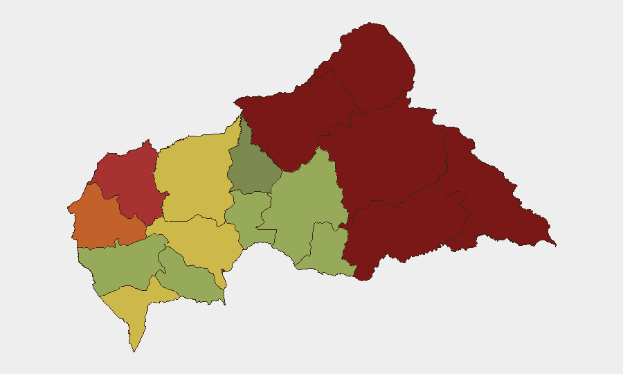
Vakaga, Bamingui-Bangoran, and Haute-Kotto prefectures dominate the risk ranking, with composite scores of 95, 92, and 88 respectively. These northeastern and northern regions are characterized by porous borders with Chad and Sudan, limited state administration, significant mineral-extraction activity (diamonds, gold), and persistent armed-group presence—including splinter factions and cross-border incursion routes. Bangui (risk 78) remains the capital and economic hub but experiences lower relative risk than outlying prefectures; however, the 30 July attack on mining personnel north of Bangui signals that insecurity is extending toward and into the metropolitan periphery. Eastern prefectures (Haut-Mbomou, Mbomou, Haute-Kotto) report elevated risk driven by banditry, mineral-related crime, and competing militia interests.
How GeoBit Would Assist
Security teams with personnel or assets in CAR should leverage AOI Monitoring & Early Warning to track Vakaga, Bangui periphery, and key road corridors for armed-group or bandit activity; OSINT fusion and multi-language search to correlate local media, social platforms, and informal networks for incident signals missed by English-language wire services; and Routing & Network Analysis to identify alternative travel routes that avoid highest-risk prefectures and supply-chain chokepoints. GIS & Spatial Analysis and satellite imagery can support site-security assessments and movement-pattern monitoring for personnel in mining or humanitarian operations.
7-Day Outlook
No major escalation is anticipated in the next 7 days, though the pattern of bandit and armed-group activity north of Bangui may continue. Diplomatic engagement (Cameroon–CAR border talks, MINUSCA posture) suggests managed rather than rapidly deteriorating conditions. Personnel and asset operators should maintain heightened vigilance in Vakaga and northeastern prefectures and assume that attacks on foreign nationals engaged in extractive sectors remain a latent, opportunistic threat.
Highest-Risk Areas — Ranked
| # | State / Region | Risk |
|---|---|---|
| 1 | Vakaga | 95 |
| 2 | Bamingui-Bangoran | 92 |
| 3 | Haute-Kotto | 88 |
| 4 | Haut-Mbomou | 85 |
| 5 | Mbomou | 82 |
| 6 | Ouham-Pendé | 79 |
| 7 | Bangui | 78 |
| 8 | Nana-Mambéré | 75 |
| 9 | Sangha-Mbaéré | 68 |
| 10 | Ouham | 65 |
| 11 | Ombella-M'Poko | 62 |
| 12 | Kémo | 58 |
Sources
Previous Daily Briefs
A new Central African Republic brief is written every day — each with its own risk map and downloadable CSV. Here's the last week; use the calendar to go further back.
📅 Browse every day by calendar →
Highlighted days have a brief. Tap a day for that day's map & analysis, or “csv” for that day's dataset ($5).
Atlas — our AI intelligence desk — emails them this snapshot personally. Nothing else, no list.