Situation Summary
Central African Republic remains a high-conflict environment (global rank #30, composite threat score 65), with armed violence against civilians and state security forces continuing in areas north and east of the capital. A Swiss geologist and Central African Army staff sergeant were killed in an armed attack north of Bangui on 2026-07-30, underscoring persistent insecurity in extraction and transport corridors. No new major incidents have been independently verified in the last 24 hours; however, the pattern of targeted violence against foreign nationals and military personnel suggests sustained operational activity by uncontrolled armed groups across the northern prefectures.
Key Developments
- Gbango-Carriere / Damara area, north of Bangui (2026-07-30): Armed men attacked a mining survey convoy, killing a Swiss geologist and a Central African Army staff sergeant. A local miner was also reportedly kidnapped during the incident, according to Central African prosecutor and international wire reports.
- No independently verified new security incidents reported in the last 24 hours. Wire services and local sources have not released corroborated accounts of additional armed clashes, mass violence, or major displacement events since 2026-08-03.
- Continued operational presence of armed groups in northern extraction zones: The 2026-07-30 attack indicates unidentified armed bandits remain active in mining survey corridors approximately 50 km north of Bangui, targeting both foreign nationals and military escorts.
Highest-Risk Areas
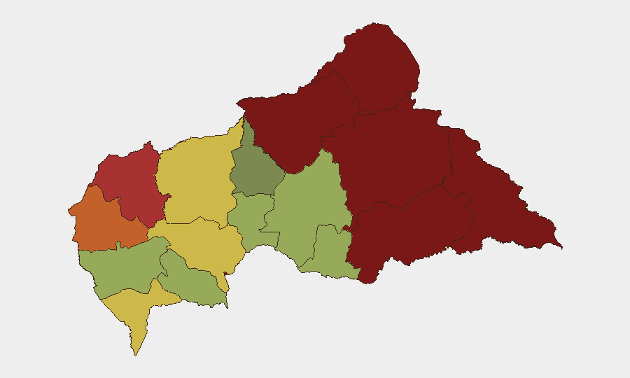
Vakaga, Bamingui-Bangoran, and Haute-Kotto prefectures in the far north and northeast carry the highest composite risk scores (95, 92, and 88 respectively), reflecting active armed group presence, limited state control, and historical banditry and cross-border trafficking. Bangui itself (risk 78) and the adjacent Ombella-M'Poko and Mbomou prefectures form a secondary high-risk belt around the capital and eastward, where armed violence, kidnapping, and robbery target both civilians and commercial transport. The concentration of risk in the northern tier (Vakaga to Haute-Kotto) correlates with mineral extraction activity, porous borders with Chad and Sudan, and weak security force reach; Bangui's persistent ranking reflects urban crime, armed group infiltration, and civil-military tensions.
How GeoBit Would Assist
Security teams should deploy AOI Monitoring & Early Warning on northern mining corridors and transport routes to Bangui to detect armed group movements and ambush preparation in near-real time. Intel Sweep and multi-language OSINT (X/Telegram, local radio SIGINT, conflict databases) would flag emerging threats and actor communication before incidents occur. Conflict & Military force-structure tracking and GIS & Spatial Analysis enable precise mapping of armed-group control zones and safe routing alternatives for personnel and supply movements, reducing exposure to high-incident areas like Gbango-Carriere.
7-Day Outlook
Armed group activity in northern prefectures is expected to remain elevated, with mining and transport operations continuing to face ambush and kidnapping risk. No major shift in the conflict's trajectory is anticipated over the next week absent external military intervention or major armed-group fragmentation. Organizations with personnel or assets in Vakaga, Bamingui-Bangoran, extraction zones, or northern Bangui hinterland should maintain elevated posture and active route intelligence.
Highest-Risk Areas — Ranked
| # | State / Region | Risk |
|---|---|---|
| 1 | Vakaga | 95 |
| 2 | Bamingui-Bangoran | 92 |
| 3 | Haute-Kotto | 88 |
| 4 | Haut-Mbomou | 85 |
| 5 | Mbomou | 82 |
| 6 | Ouham-Pendé | 79 |
| 7 | Bangui | 78 |
| 8 | Nana-Mambéré | 75 |
| 9 | Sangha-Mbaéré | 68 |
| 10 | Ouham | 65 |
| 11 | Ombella-M'Poko | 62 |
| 12 | Kémo | 58 |
Sources
Previous Daily Briefs
A new Central African Republic brief is written every day — each with its own risk map and downloadable CSV. Here's the last week; use the calendar to go further back.
📅 Browse every day by calendar →
Highlighted days have a brief. Tap a day for that day's map & analysis, or “csv” for that day's dataset ($5).
Atlas — our AI intelligence desk — emails them this snapshot personally. Nothing else, no list.