Situation Summary
Iran remains in a volatile U.S.–Iran military conflict environment, with a temporary pause in air operations as of July 26–29, 2026, but no durable ceasefire agreement in place. The pause is fragile; U.S. Central Command completed 13 consecutive nights of strikes targeting coastal and maritime-linked infrastructure through July 25, and both sides have stated conditions under which strikes could resume. Diplomatic talks continue at Bürgenstock, Switzerland, but the security picture remains unpredictable, with civilian infrastructure, maritime transit, and air travel subject to rapid disruption.
Key Developments
- July 29, 2026 – Conventional Military Force Events (Washington vs. Iran; Islamic State vs. Iran). GEOBIT event signals register multiple military-force interactions on the most recent reporting date, indicating continued tension and potential secondary engagements despite the stated pause in U.S. air operations.
- July 26, 2026 – U.S.–Iran Attack Pause (Coastal Areas, Strait of Hormuz Region). The United States paused air attacks for a second consecutive day; Iranian authorities stated they halted retaliatory strikes. This follows 13 consecutive nights of U.S. strikes targeting coastal and maritime infrastructure. The pause reduces immediate kinetic risk but remains reversible on short notice.
- July 25, 2026 – Strait of Hormuz Closure Announced (Iran's Southern Coastal Waters). Iran's Khatam al-Anbiya Central Headquarters announced closure of the Strait of Hormuz to maritime traffic, citing alleged U.S. and Israeli ceasefire breaches. This disrupts shipping and energy transit, creating acute risk for vessels and supply chains dependent on the waterway.
- July 25, 2026 – Diplomatic Engagement Confirmed (Bürgenstock, Switzerland). Swiss Foreign Ministry confirmed ongoing, discrete U.S.–Iran talks on implementing a memorandum of understanding. The channel remains open, but no agreement timeline is disclosed; military risk persists pending negotiated de-escalation.
- Late July 2026 – Foreign Travel Advisories Escalated. Canada's travel advisory urges avoidance of all Iran travel and recommends departure for those already present, citing drones, missiles, and infrastructure strikes. Flight cancellations and transport disruptions are likely if military activity resumes.
Highest-Risk Areas
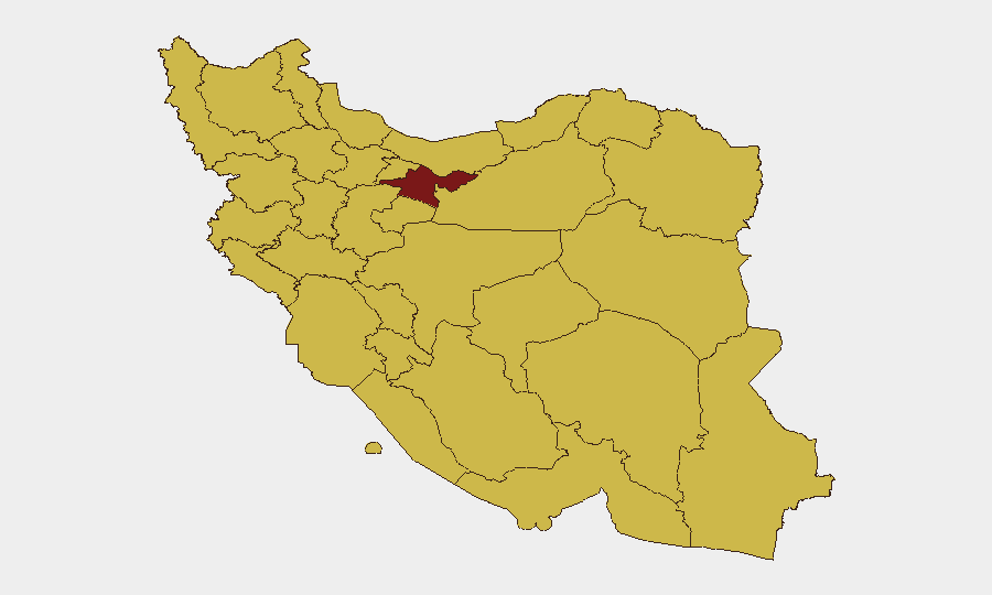
Tehran Province (96.8) dominates the risk ranking, reflecting its role as the national capital, command center, and primary target for military and diplomatic activity. Isfahan Province (69.6) and Bushehr Province (68.9) follow, with Bushehr's proximity to the Strait of Hormuz and coastal infrastructure making it particularly vulnerable to maritime-focused strikes and supply-chain disruption. Khuzestan Province (68.3) and Alborz Province (67.9) round out the top tier; all five provinces are either urban centers, energy hubs, or military command nodes. The clustering of secondary provinces (67–68 range) reflects nationwide infrastructure vulnerability rather than localized unrest.
How GeoBit Would Assist
Duty-of-care teams would deploy AOI (Area-of-Interest) Monitoring & Early Warning on corporate facilities and personnel clusters in Tehran, Isfahan, Bushehr, and Khuzestan to detect resumption of strikes, air-traffic disruptions, or security incidents in real time. Maritime & Aviation Tracking, combined with Routing & Network Analysis, would enable alternative supply-chain and evacuation planning around Strait of Hormuz closures and airspace restrictions. Intel Sweep and multi-language OSINT on Iranian state media, military announcements, and diplomatic channels would provide 12–36 hour early warning of ceasefire breakdown.
7-Day Outlook
The current pause is expected to hold through early August pending outcome of Swiss negotiations, but the risk of strike resumption remains elevated if either side perceives ceasefire violations. Maritime and air routes will remain constrained. Corporate security postures should assume 48-hour escalation potential and maintain evacuation readiness for personnel in high-risk provinces.
Highest-Risk Areas — Ranked
| # | State / Region | Risk |
|---|---|---|
| 1 | Tehran Province | 96.8 |
| 2 | Isfahan Province | 69.6 |
| 3 | Bushehr Province | 68.9 |
| 4 | Khuzestan Province | 68.3 |
| 5 | Alborz Province | 67.9 |
| 6 | East Azerbaijan Province | 67.8 |
| 7 | Fars Province | 67.6 |
| 8 | Gilan Province | 67.5 |
| 9 | Kerman Province | 67.3 |
| 10 | Zanjan Province | 67.2 |
| 11 | Sistan and Baluchestan Province | 67.1 |
| 12 | Razavi Khorasan | 67 |
Sources
Previous Daily Briefs
A new Iran brief is written every day — each with its own risk map and downloadable CSV. Here's the last week; use the calendar to go further back.
📅 Browse every day by calendar →
Highlighted days have a brief. Tap a day for that day's map & analysis, or “csv” for that day's dataset ($5).
Atlas — our AI intelligence desk — emails them this snapshot personally. Nothing else, no list.