Situation Summary
Central African Republic remains a complex operating environment with persistent armed-group activity, banditry, and weak state security capacity across much of the territory. The composite national threat score of 65 reflects active but regionally fragmented insurgent and criminal threats rather than nationwide collapse. Recent weeks have seen targeted attacks on civilian and military personnel in accessible zones north of Bangui, signaling that proximity to the capital provides limited insulation from violence.
Key Developments
- 2026-08-05, Bahachay (Vakaga prefecture, near Birao): Armed bandits conducted an attack resulting in three deaths, including a Russes-Noirs security volunteer; attackers abandoned four motorcycles at the scene and fled.
- 2026-07-30, Damara corridor (c. 50 km north of Bangui): A Swiss mining-survey geologist and a Central African Army staff sergeant were killed in an armed attack; a second CAR soldier was kidnapped during the incident. The attack suggests organized targeting of civilian technical workers and military personnel on regional routes.
- 2026-08-03, Am-Dafok area (northern border zone): Russian security specialists concluded mopping-up operations following detention of an illegal armed-group member linked to a June 30 attack; indicates ongoing pursuit operations but reflects earlier incident patterns.
- 2026-08-03, Bangui and suburban zones: Joint police–gendarmerie operations continued against illicit drug trafficking and public-order maintenance in suburban areas; operational tempo suggests elevated coordination but no specific security incident reported in this window.
Highest-Risk Areas
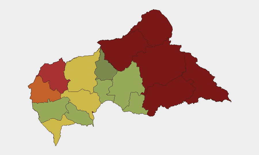
Vakaga and Bamingui-Bangoran (risk scores 95 and 92 respectively) dominate the threat landscape, with Haute-Kotto, Haut-Mbomou, and Mbomou (88, 85, 82) forming a volatile eastern corridor. These five prefectures are remote, poorly garrisoned, and host fluid armed-group and bandit networks with limited state presence. The recent Bahachay attack in Vakaga and the Damara incident near Bangui indicate that even zones closer to the capital remain penetrable; Bangui itself (risk 78) reflects persistent street-crime, trafficking, and organized-banditry risk despite state security operations.
How GeoBit Would Assist
Security teams operating in Central African Republic should deploy AOI Monitoring & Early Warning on the Damara–Gbango corridor and key mining/commercial routes north of Bangui to detect armed-group repositioning and convoy-attack patterns. Network & Actor Analysis and OSINT fusion (X/Telegram monitoring, radio SIGINT) would help identify the perpetrator networks behind the recent mining-convoy and Vakaga attacks and track their operational cells. Routing & Network Analysis tools enable alternative-route planning that circumvents high-incident zones while Conflict & Military force-structure tracking maintains current visibility on FACA deployments and Russian-specialist operation areas.
7-Day Outlook
Armed-banditry and targeted attacks on civilian infrastructure and military personnel are likely to persist in remote and peri-urban zones. The kidnapping of a FACA soldier and the targeting of foreign technical workers suggest that perpetrator groups may escalate pressure on state security and international business operations. Expect continued joint security operations (police, gendarmerie, Russian advisors) with variable operational effect in eastern and northern prefectures.
Highest-Risk Areas — Ranked
| # | State / Region | Risk |
|---|---|---|
| 1 | Vakaga | 95 |
| 2 | Bamingui-Bangoran | 92 |
| 3 | Haute-Kotto | 88 |
| 4 | Haut-Mbomou | 85 |
| 5 | Mbomou | 82 |
| 6 | Ouham-Pendé | 79 |
| 7 | Bangui | 78 |
| 8 | Nana-Mambéré | 75 |
| 9 | Sangha-Mbaéré | 68 |
| 10 | Ouham | 65 |
| 11 | Ombella-M'Poko | 62 |
| 12 | Kémo | 58 |
Sources
Previous Daily Briefs
A new Central African Republic brief is written every day — each with its own risk map and downloadable CSV. Here's the last week; use the calendar to go further back.
📅 Browse every day by calendar →
Highlighted days have a brief. Tap a day for that day's map & analysis, or “csv” for that day's dataset ($5).
Atlas — our AI intelligence desk — emails them this snapshot personally. Nothing else, no list.