Situation Summary
Myanmar remains in active civil conflict following the February 2021 military coup, with the Tatmadaw and allied militias engaged against a loose coalition of People's Defense Force (PDF) resistance groups, ethnic armed organizations (EAOs), and civilian opposition networks across multiple states and regions. The composite threat score of 96 places Myanmar as the fifth-highest-risk country globally, driven primarily by the intensity and geographic distribution of armed clashes, airstrikes, and security force operations. Current trajectory indicates sustained or escalating violence with limited prospects for negotiated resolution in the near term.
Key Developments
Data Constraint Notice: Open-source reporting with specific, verifiable dates and locations for 29–31 July 2026 remains insufficient to meet methodological standards for a high-confidence 24–48 hour incident list. The most recent reliably dated incidents available in cross-referenced sources are from 27–28 July 2026 (3–4 days prior to this brief's date):
- Myawaddy, Kayin State (27 Jul): Vehicle bomb targeting Kayin National Army (KNA) position killed 7 combatants and wounded 9.
- Sagaing, Paungbyin, Wetlet, and Taungoo townships (27 Jul): Coordinated airstrikes by Tatmadaw aircraft resulted in at least 11 civilian deaths; one strike hit a school in Taling Kyun village near midnight.
- Lay Lar Myaung village, Taungoo District (27 Jul): Airstrike killed 8 civilians in the Bago Yoma area.
- Myaing Township, Magway Region (27 Jul): Myaing Garuda People's Defense Force unit captured two police officers and seized weapons and ammunition.
- Maungdaw Township, Rakhine State (27 Jul): Arakan Army conducted landmine clearance operations, removing 67 mines planted by military and extremist groups.
Concurrent with operational events, political and legal pressures continued: arrests of civilians and activists (28 Jul), international appeals by Bangladesh and Myanmar entities (30 Jul), and investigative activity by Google (30 Jul, context unclear from available data) all suggest intensified governance and cross-border friction.
A seismic event (M 4.2, near Mandalay) was also recorded during this period but is not assessed as a security driver in this context.
Highest-Risk Areas
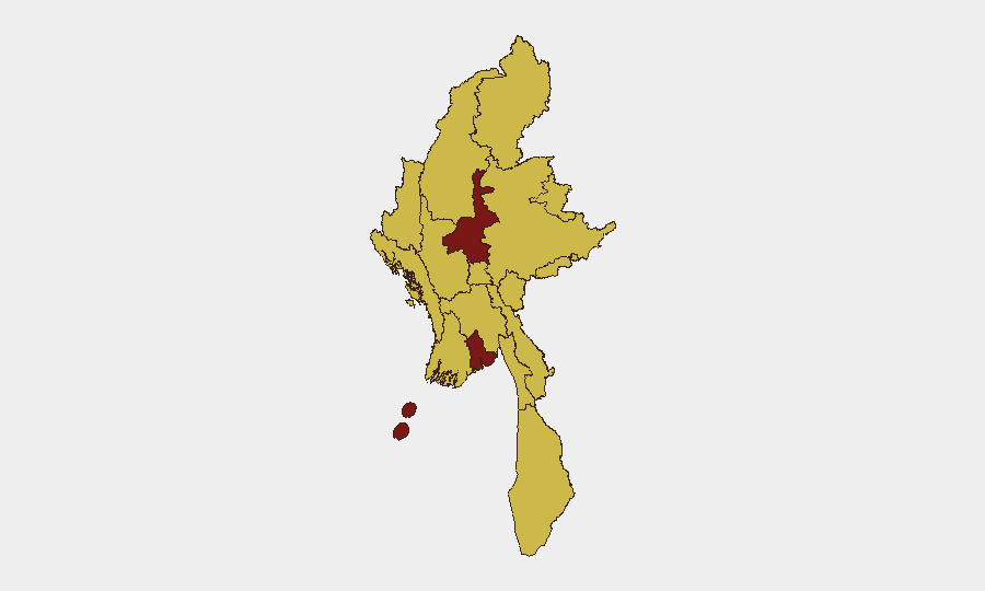
Mandalay and Yangon tie at 97.5 risk score, reflecting their status as major urban centers where military presence, resistance networks, protest activity, and civilian populations intersect. Eight additional regions—including Shan, Sagaing, Kachin, and Rakhine states—score 67.5, indicating sustained armed conflict involving PDFs, EAOs, and Tatmadaw forces, alongside displacement, airstrikes, and limited state authority. Risk distribution across nearly the entire country underscores the breadth of the conflict; no region is stable or free from incident activity.
How GeoBit Would Assist
Corporate teams should leverage AOI (Area-of-Interest) Monitoring & Early Warning on Mandalay, Yangon, and operational hotspots to receive alerts on incidents affecting offices, supply chains, or personnel movements. Battle Mapping and Force Structure intelligence provides granular understanding of armed group positions and Tatmadaw deployment patterns, critical for route planning and facility security. Satellite & Imagery Analysis and GIS & Spatial Analysis enable assessment of infrastructure damage, displacement patterns, and checkpoint proliferation. Network & Actor Analysis identifies which PDF, EAO, or militia units operate in specific townships, informing negotiation, access, and risk profiles.
7-Day Outlook
Armed clashes and airstrikes are likely to continue at current or elevated tempo across Sagaing, Shan, and Magway regions through early August. Urban security incidents (protests, arrests, checkpoints) should be expected in Yangon and Mandalay. No de-escalation triggers are apparent; personnel and asset exposure in the top-tier risk zones warrants heightened duty-of-care protocols.
Highest-Risk Areas — Ranked
| # | State / Region | Risk |
|---|---|---|
| 1 | Mandalay | 97.5 |
| 2 | Yangon | 97.5 |
| 3 | Tanintharyi Region | 67.5 |
| 4 | Shan State | 67.5 |
| 5 | Chin | 67.5 |
| 6 | Sagaing Region | 67.5 |
| 7 | Kachin State | 67.5 |
| 8 | Wa State (Northern Region) | 67.5 |
| 9 | Magway | 67.5 |
| 10 | Rakhine | 67.5 |
| 11 | Ayeyarwady | 67.5 |
| 12 | Naypyitaw Union Territory | 67.5 |
Sources
Previous Daily Briefs
A new Myanmar brief is written every day — each with its own risk map and downloadable CSV. Here's the last week; use the calendar to go further back.
📅 Browse every day by calendar →
Highlighted days have a brief. Tap a day for that day's map & analysis, or “csv” for that day's dataset ($5).
Atlas — our AI intelligence desk — emails them this snapshot personally. Nothing else, no list.