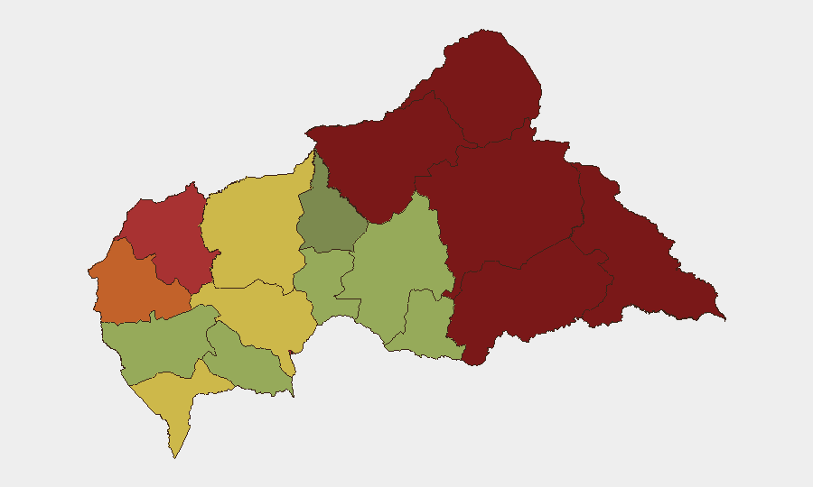
Situation Summary
Central African Republic remains a high-crime, fragmented security environment with composite threat ranking #30 globally (score 65). The past week has seen sustained armed violence against civilians in remote prefectures and a high-profile kidnapping-murder of a Swiss national near the capital, prompting official criminal investigation. While no 0-tracked-events threshold has been breached, the pattern of attacks across geographically dispersed zones and cross-border friction with Cameroon indicates persistent instability without signs of near-term de-escalation.
Key Developments
- Bangui / Damara corridor (2026-08-08/09): CAR authorities opened criminal investigation into the abduction and killing of Swiss geologist Luca Maggini and a CAR Army staff sergeant at a gold-prospecting site north of Bangui. Bodies recovered; search operations continued. Incident underscores targeting of foreign nationals and security personnel in mining zones.
- Imohoro, ~50 km north of Bangui (2026-08-09): Armed attack at gold-prospecting site resulted in death of Swiss national and Central African soldier. Security patrols and follow-up operations reported ongoing in the area.
- Cameroon–CAR border consultations (early August): Interior ministers of Cameroon and CAR met in Yaoundé to address border insecurity, cross-border crime, and irregular migration—signaling official acknowledgment of acute transnational security tension along the frontier.
- Bimbo, Bangui outskirts (2026-08-07): Fuel tanker crash struck roadside bars, causing multiple fatalities. Incident affects local movement and travel safety in capital vicinity.
- Vakaga prefecture / Birao axis (2026-08-05): Armed men attacked Arédéba village (~40 km from Birao), killing one person and injuring two. Follows earlier raid on Bahachay (40+ km from Birao) with 3 fatalities, including security volunteers.
Highest-Risk Areas
Vakaga (risk 95), Bamingui-Bangoran (92), and Haute-Kotto (88) in the north and northeast drive the sub-national ranking, reflecting active armed group presence, inter-communal conflict, and limited state control in remote mining and pastoralist zones. Bangui itself (risk 78) and surrounding Ombella-M'Poko (62) face crime, robbery, and targeted violence but remain comparatively more accessible. The concentration of kidnapping and armed attacks in the Bangui–Damara corridor and around Birao indicates that both the capital region and the far northeast remain priority threat zones for foreign nationals and logistics operations, despite differing underlying drivers (mining-site banditry vs. group-based armed activity).
How GeoBit Would Assist
Teams managing personnel or assets in CAR should deploy AOI Monitoring & Early Warning on high-risk prefectures (Vakaga, Bangui, Damara–Imohoro corridor) to receive real-time alerts on armed incidents and kidnapping patterns. Conflict & Military and Network & Actor Analysis capabilities enable identification of armed actors, their movement, and targeting preferences (e.g., foreign nationals in mining zones). Routing & Network Analysis supports identification of safer transit corridors and alternative supply routes away from Birao–Am-Dafock and Bangui–Damara axes during elevated threat periods.
7-Day Outlook
Expect continued sporadic armed violence in remote northern prefectures and persistent crime pressure in Bangui. Cross-border Cameroon–CAR tensions may generate localized checkpoints and security patrols that complicate movement along frontier routes. Mining-site kidnappings and banditry are likely to persist absent rapid force deployment or negotiated settlements with armed groups.
Highest-Risk Areas — Ranked
| # | State / Region | Risk |
|---|---|---|
| 1 | Vakaga | 95 |
| 2 | Bamingui-Bangoran | 92 |
| 3 | Haute-Kotto | 88 |
| 4 | Haut-Mbomou | 85 |
| 5 | Mbomou | 82 |
| 6 | Ouham-Pendé | 79 |
| 7 | Bangui | 78 |
| 8 | Nana-Mambéré | 75 |
| 9 | Sangha-Mbaéré | 68 |
| 10 | Ouham | 65 |
| 11 | Ombella-M'Poko | 62 |
| 12 | Kémo | 58 |
Sources
Previous Daily Briefs
A new Central African Republic brief is written every day — each with its own risk map and downloadable CSV. Here's the last week; use the calendar to go further back.
📅 Browse every day by calendar →
Highlighted days have a brief. Tap a day for that day's map & analysis, or “csv” for that day's dataset ($5).
Atlas — our AI intelligence desk — emails them this snapshot personally. Nothing else, no list.