Situation Summary
Iran remains in a state of suspended hostilities following a mutual pause in attacks initiated on July 26–27, 2026. The broader US–Iran conflict that escalated in late July has not produced verified new strikes or major security incidents *inside Iran's territory* in the last 24–48 hours; however, the pause is fragile and contingent on continued restraint by both parties. Risk remains elevated across all provinces, particularly Tehran and the northwestern border regions, driven by the proximity of earlier strikes, ongoing military posturing, and unresolved trigger points in the Strait of Hormuz and regional proxy activity.
Key Developments
- No verified new strikes or mass incidents inside Iran (last 48h). ACLED's latest crisis data (through July 28) and major open-source feeds contain no timestamped reports of new attacks, protests, or infrastructure damage within Iran's borders as of August 1, 2026.
- Strait of Hormuz closure order remains in effect. Iran's Khatam al-Anbiya Central Headquarters announced closure of the Strait, citing alleged ceasefire violations, though the exact enforcement timeline and compliance remain unclear as of reporting cutoff.
- Mutual attack pause holds (since July 26–27). Both the United States and Iran have reportedly paused offensive operations, though neither side has formally committed to a ceasefire, leaving the cessation subject to rapid reversal if trigger events occur.
- Regional proxy activity continues. Iraq-based armed groups attributed to Iranian networks have conducted drone and missile strikes on Saudi and Emirati targets; these regional operations do not breach the internal-Iran pause but increase regional destabilization risk.
- US carrier and coalition forces maintain elevated posture in the Gulf. Military statements from the US and allied nations (Saudi Arabia, Kuwait, Qatar) from July 29–31 underscore continued defensive positioning, though no new strike declarations have been issued in the last 24 hours.
Highest-Risk Areas
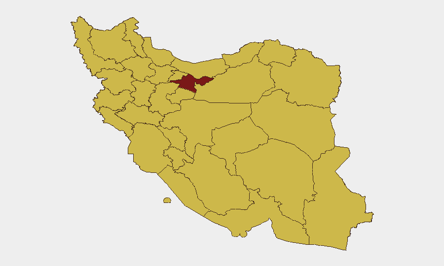
Tehran Province (risk 97) dominates the national threat landscape due to its role as the political and military command center; any resumption of strikes would likely target IRGC and government facilities there. Northwestern provinces—Kurdistan, East Azerbaijan, and Ardabil—face elevated risk owing to proximity to the Iraq border and historical use as staging grounds for proxy operations and cross-border militia activity. Bushehr and Hormozgan provinces remain exposed due to their critical role in energy infrastructure and maritime chokepoint control; any escalation in Strait of Hormuz enforcement or further regional conflict could rapidly increase their vulnerability. The clustering of risk in the top six provinces reflects concentration of military, governmental, and petroleum assets rather than widespread internal instability.
How GeoBit Would Assist
Intel Sweep and multi-language OSINT fusion enable real-time monitoring of Iranian military communications, official statements, and regional actor signaling to detect early indicators of pause breakdown. Satellite & imagery analysis and AOI monitoring with alerting on key military installations (IRGC bases, missile facilities, ports) provide persistent watch capability to flag movement, mobilization, or damage patterns before public confirmation. Network & actor analysis combined with maritime tracking help security teams monitor IRGC command decisions and proxy movements in Iraq/Syria that may presage escalation spillover into Iranian territory.
7-Day Outlook
The pause is likely to persist through early August absent a major catalyzing event (e.g., alleged ceasefire breach, regional incident, or domestic political pressure for retaliation). Risk of rapid escalation remains acute; surveillance of US military messaging, Iranian IRGC statements, and Iraqi militia activity will be critical indicators of intent. Organizations with personnel or assets in Tehran and northwestern provinces should maintain contingency evacuation plans and avoid large gatherings pending stabilization.
Highest-Risk Areas — Ranked
| # | State / Region | Risk |
|---|---|---|
| 1 | Tehran Province | 97 |
| 2 | Kurdistan Province | 69.5 |
| 3 | Bushehr Province | 69.3 |
| 4 | East Azerbaijan Province | 68.7 |
| 5 | Alborz Province | 68.4 |
| 6 | Isfahan Province | 68.2 |
| 7 | Khuzestan Province | 67.6 |
| 8 | Razavi Khorasan | 67.5 |
| 9 | Kermanshah Province | 67.3 |
| 10 | Ardabil Province | 67.2 |
| 11 | Hormozgan Province | 67.1 |
| 12 | Markazi Province | 67.1 |
Sources
Previous Daily Briefs
A new Iran brief is written every day — each with its own risk map and downloadable CSV. Here's the last week; use the calendar to go further back.
📅 Browse every day by calendar →
Highlighted days have a brief. Tap a day for that day's map & analysis, or “csv” for that day's dataset ($5).
Atlas — our AI intelligence desk — emails them this snapshot personally. Nothing else, no list.