Situation Summary
Central African Republic remains a persistent, fragmented insurgency and criminality environment with composite threat score 65 and no major escalation over the past 48 hours. The killing of Swiss geologist Luca Maggini in late July, coupled with recurring bandit attacks in Vakaga and Bamingui-Bangoran prefectures and fresh border tensions with Cameroon, signal sustained instability across northern and eastern zones. No single dominant armed actor currently commands the country; dispersed criminal networks, militia fragments, and cross-border incursion risk characterize the operating environment. Risk trajectory remains sideways to slightly elevated, with seasonal mobility and August rains likely to fragment armed activity further.
Key Developments
- Yaoundé, Cameroon–CAR border zone (10 Aug 2026): Interior ministers of Cameroon and CAR held bilateral security talks to address cross-border crime, irregular migration, and armed incursion coordination—signaling official recognition of acute frontier instability and intent to improve formal liaison following the 1 August detention of two Cameroonian gendarmes near Gasol.
- Bangui & mining sector (ongoing from 31 Jul incident): CAR authorities have tightened security protocols around mining sites north of the capital following the criminal investigation into Maggini's abduction and killing; no fresh mining-area attacks reported in the last 48 hours, but risk remains elevated for foreign nationals in remote extraction zones.
- Birao region (5 Aug 2026): Armed bandit attack on Bahachay village (~40 km from Birao, Vakaga prefecture) resulted in three fatalities, including two assailants; perpetrators fled on motorcycles, consistent with mobile criminal cell tactics common in northeastern CAR since July.
- Cross-border gendarme arrests (1 Aug 2026): Two Cameroonian gendarmes detained near Gasol by Bangui authorities following alleged unauthorized armed entry into CAR territory; incident reflects wider Cameroon–CAR friction and irregular security force behavior along the 1,500+ km frontier.
- No new major incidents confirmed in 48-hour window: While bandit activity continues in peripheral zones (particularly Vakaga, Haute-Kotto), no fresh mass-casualty events, large-scale kidnappings, or coordinated insurgent operations have been reported since 7 August.
Highest-Risk Areas
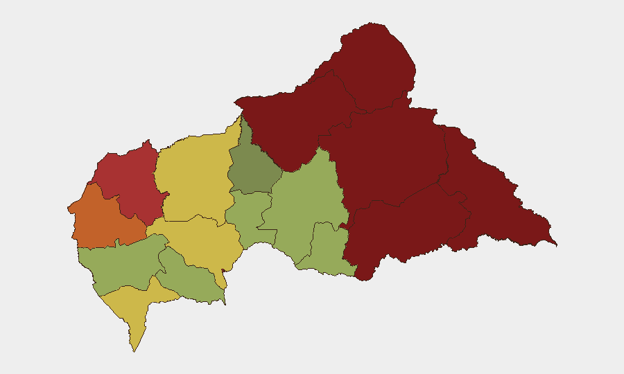
Vakaga (risk 95) and Bamingui-Bangoran (risk 92) prefectures dominate the risk landscape, driven by proximity to ungoverned space in Chad, limited state presence, and prevalence of mobile bandit networks operating across porous borders. Haute-Kotto (88) and Haut-Mbomou (85) in the east present secondary risk clusters tied to militia activity and informal armed competition for mineral and trafficking routes. Bangui itself (78) merits corporate attention: the capital concentrates kidnapping risk, petty crime, and political friction, while mining and quarry operations 40–55 km north (Ombella-M'Poko, Kémo) remain zones of abduction and bandit predation. Eastern and northern prefectures should be treated as restricted or high-friction zones for non-essential personnel.
How GeoBit Would Assist
Security teams would deploy AOI Monitoring & Early Warning on high-risk prefectures (Vakaga, Bamingui-Bangoran, mining sites) with persistent alerting on bandit mobilization, armed group activity, and cross-border incursions. Intel Sweep, multi-language OSINT, and X/Twitter monitoring enable real-time detection of kidnapping threats, militia reorganization, and border incidents. Routing & Network Analysis and GIS & Spatial Analysis support duty-of-care route planning for personnel in northern zones, identifying safer corridors and staging areas during periods of heightened incident frequency.
7-Day Outlook
Bandit activity in Vakaga and northern prefectures will likely remain steady or decline as August rainy season intensifies, constraining vehicle mobility and regrouping across borders. Border tensions with Cameroon may produce additional detention incidents or informal military posturing, though formal conflict escalation is unlikely. Risk to foreign nationals engaged in mining, humanitarian, or diplomatic work should be assumed constant; no improvement expected before mid-month.
Highest-Risk Areas — Ranked
| # | State / Region | Risk |
|---|---|---|
| 1 | Vakaga | 95 |
| 2 | Bamingui-Bangoran | 92 |
| 3 | Haute-Kotto | 88 |
| 4 | Haut-Mbomou | 85 |
| 5 | Mbomou | 82 |
| 6 | Ouham-Pendé | 79 |
| 7 | Bangui | 78 |
| 8 | Nana-Mambéré | 75 |
| 9 | Sangha-Mbaéré | 68 |
| 10 | Ouham | 65 |
| 11 | Ombella-M'Poko | 62 |
| 12 | Kémo | 58 |
Sources
Previous Daily Briefs
A new Central African Republic brief is written every day — each with its own risk map and downloadable CSV. Here's the last week; use the calendar to go further back.
📅 Browse every day by calendar →
Highlighted days have a brief. Tap a day for that day's map & analysis, or “csv” for that day's dataset ($5).
Atlas — our AI intelligence desk — emails them this snapshot personally. Nothing else, no list.