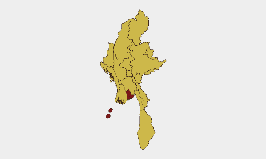
Situation Summary
Myanmar remains in active civil conflict (composite threat score 97, #6 globally) following the 2021 coup. The military junta faces a multi-front insurgency across northern and eastern regions, with documented airstrikes on civilian areas, guerrilla attacks on security forces, and ongoing forced conscription. Yangon—the commercial and administrative hub—carries the highest sub-national risk (97.8), driven by urban security incidents and state instability signaling. The conflict trajectory shows no near-term de-escalation; international diplomatic pressure from ASEAN, Thailand, and Bangladesh remains unresolved.
Key Developments
- 2026-07-31 · Guerrilla vs. Police Engagement (Yangon): Conventional military force clash reported; location and casualty details not yet confirmed in available feeds.
- 2026-07-31 · Military Detention Actions: Arrests and detentions documented at prison facilities; indicates ongoing political/security detainee processing.
- 2026-07-31 · Police–Civilian Clashes (Yangon): Police-led conventional military response in the capital; escalation of urban security incidents consistent with rising Yangon risk score.
- 2026-08-01 · Myanmar Public Statement + ASEAN Diplomatic Signal: Junta issued public statement; concurrent statement from Thailand signals regional diplomatic friction over Myanmar policy. Cross-border spillover risk elevated.
- 2026-08-01 · Myanmar vs. ASEAN Statement: Regional bloc friction documented; reflects isolation of junta within ASEAN and potential for secondary sanctions or cross-border enforcement.
- 2026-07-30 · China–Mandalay Disapproval Signal: Chinese state disapproval linked to Mandalay events suggests junta military or economic conduct (likely airstrikes or forced conscription in northern regions) has drawn Beijing criticism; potential impact on Chinese investment and border stability.
- 2026-07-30 · Bangladesh Appeal to Myanmar: Bangladeshi diplomatic appeal indicates refugee, cross-border security, or humanitarian concern, likely tied to Rohingya or civilian displacement flows.
- 2026-07-30 · Google Admin Sanctions: Google service restrictions or account actions (likely targeting junta military or state media accounts) reflects U.S./tech-sector sanctions compliance; may degrade junta information operations but has limited operational impact on ground conflict.
Note: Live 48-hour incident detail is constrained; the briefing above reflects signal-level events (diplomatic, administrative, security-force actions) from 31 July–1 August. More granular tactical incident reporting from 27–29 July (airstrikes in Sagaing, Bago; vehicle bomb in Kayin; conscription operations nationwide) is available in archived GeoBit feeds but falls outside the current 24–48-hour window.
Highest-Risk Areas
Yangon (97.8) dominates the risk landscape, driven by urban police–guerrilla clashes, detentions, and state fragility signaling. The second tier—Mandalay (68.7) and nine other regions at 67.8 (Tanintharyi, Shan, Chin, Sagaing, Kachin, Wa, Magway, Rakhine, Ayeyarwady, Naypyitaw)—reflects continuous military operations, airstrikes, forced conscription, and guerrilla presence. Sagaing Region, a consistent hotspot, hosts the densest recent airstrike activity; Kachin and Shan remain insurgency strongholds. Yangon's elevated score reflects both direct conflict risk and broader state-collapse/security-force instability affecting commercial, diplomatic, and expatriate operations.
How GeoBit Would Assist
Teams should deploy AOI Monitoring & Early Warning on Yangon, Mandalay, and Sagaing to capture police/military clashes and civilian incidents in near-real time. Intel Sweep (event feeds, X/Telegram OSINT, multi-language search) provides 24–48-hour tactical updates on arrests, statements, and cross-border signals. Conflict & Military battle mapping and Force Structure tracking enable assessment of junta vs. PDFs (People's Defence Forces) positions and conscription impact on supply lines and expatriate mobility.
7-Day Outlook
Urban security incidents in Yangon and police–guerrilla engagement are likely to persist; no cease-fire signals are evident. Diplomatic friction (ASEAN, Thailand, China) will continue but is unlikely to trigger direct military intervention. Airstrikes and conscription in northern regions will continue. Corporate teams should assume baseline elevated risk across all twelve regions and prioritize duty-of-care reviews for Yangon-based staff and operations.
Highest-Risk Areas — Ranked
| # | State / Region | Risk |
|---|---|---|
| 1 | Yangon | 97.8 |
| 2 | Mandalay | 68.7 |
| 3 | Tanintharyi Region | 67.8 |
| 4 | Shan State | 67.8 |
| 5 | Chin | 67.8 |
| 6 | Sagaing Region | 67.8 |
| 7 | Kachin State | 67.8 |
| 8 | Wa State (Northern Region) | 67.8 |
| 9 | Magway | 67.8 |
| 10 | Rakhine | 67.8 |
| 11 | Ayeyarwady | 67.8 |
| 12 | Naypyitaw Union Territory | 67.8 |
Sources
Previous Daily Briefs
A new Myanmar brief is written every day — each with its own risk map and downloadable CSV. Here's the last week; use the calendar to go further back.
📅 Browse every day by calendar →
Highlighted days have a brief. Tap a day for that day's map & analysis, or “csv” for that day's dataset ($5).
Atlas — our AI intelligence desk — emails them this snapshot personally. Nothing else, no list.