Situation Summary
Central African Republic remains a high-fragmentation conflict environment with composite threat score 65 (#32 globally), driven primarily by ongoing insurgency, banditry, and cross-border armed activity. The country has experienced a sustained pattern of localized violence against civilians, abductions targeting foreigners, and weapons trafficking over the past two weeks, with no indication of de-escalation. Northern and eastern prefectures (Vakaga, Bamingui-Bangoran, Haute-Kotto) remain significantly more dangerous than the capital or southern regions, though Bangui itself carries elevated risk (78) due to criminal activity and occasional spillover.
Key Developments
- Bangui/Damara quarry area (50 km north) — 7 August 2026: CAR authorities opened a criminal investigation following the confirmed death of Swiss geologist Luca Maggini and a CAR military escort, who were abducted on 31 July by armed men in a quarrying zone. Status of abductors unknown.
- Cameroon–CAR border — 10 August 2026: Interior ministers of Cameroon and CAR conducted bilateral security talks in response to recurring cross-border armed incursion, irregular migration, and smuggling. Two Cameroonian gendarmes were detained by Bangui authorities on 1 August after unauthorized armed entry near Gasol.
- Bimbo (Bangui outskirts) — 7 August 2026: A fuel tanker crash struck roadside bars, causing multiple fatalities and localized traffic disruption. Attributed to accident rather than hostile action.
- Vakaga Prefecture villages — 5 August 2026: Two separate bandit/armed attacks occurred: Arédéba village (40 km from Birao) resulted in 1 killed, 2 injured; Bahachay (40+ km from Birao) saw 3 deaths (1 local security recruit, 2 assailants). Perpetrators fled on motorcycles; pattern consistent with mobile bandit operations.
- Disarmament and law enforcement (3–9 August aggregate) — Russian-aligned forces and CAR gendarmerie conducted weapons recovery operations across multiple prefectures: 69 voluntary surrenders in Malum; weapons caches seized near Bosangua and Atongo-Bockari (including heavy machine guns); 25 foreign nationals (Chad, Sudan) detained in Bangui on immigration violations; large cannabis plantation destroyed near Bouar.
Highest-Risk Areas
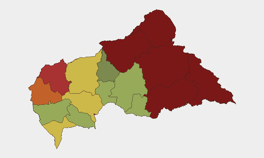
Vakaga and Bamingui-Bangoran prefectures (risk scores 95 and 92) dominate the threat landscape, driven by sustained bandit activity, weak state presence, and porous border areas facilitating cross-border militant movement and supply lines. Haute-Kotto, Haut-Mbomou, and Mbomou (scores 88–82) form a contiguous high-risk corridor in the east and southeast, characterized by armed group activity and limited government control. Bangui itself (78) remains elevated due to urban crime, smuggling networks, and proximity to areas of armed activity, though it experiences lower direct-fire violence than peripheral zones. Risk declines sharply in western and southwestern prefectures (Kémo, Ombella-M'Poko, Ouham below 65).
How GeoBit Would Assist
Security teams with personnel or assets in CAR should employ AOI Monitoring & Early Warning on high-risk prefectures (Vakaga, Bamingui-Bangoran, and border zones) to track emerging bandit or militant activity with real-time alerting; Routing & Network Analysis to identify safer transit corridors and alternative supply chains around confirmed threat nodes; and Intel Sweep combined with OSINT fusion & corroboration to monitor Telegram, local reporting, and cross-border crime networks for indicators of abduction risk or armed group mobilization.
7-Day Outlook
Current trajectory suggests sustained low-intensity bandit and criminal violence in peripheral zones, with cross-border security coordination between Cameroon and CAR likely to generate intermittent detentions or skirmishes near Gasol and other transit points. The Maggini investigation and ongoing weapons disarmament suggest marginal state capacity gains, but no reduction in underlying fragmentation is expected over seven days. Personnel in Vakaga, Bamingui-Bangoran, and Haute-Kotto should maintain heightened vigilance.
Highest-Risk Areas — Ranked
| # | State / Region | Risk |
|---|---|---|
| 1 | Vakaga | 95 |
| 2 | Bamingui-Bangoran | 92 |
| 3 | Haute-Kotto | 88 |
| 4 | Haut-Mbomou | 85 |
| 5 | Mbomou | 82 |
| 6 | Ouham-Pendé | 79 |
| 7 | Bangui | 78 |
| 8 | Nana-Mambéré | 75 |
| 9 | Sangha-Mbaéré | 68 |
| 10 | Ouham | 65 |
| 11 | Ombella-M'Poko | 62 |
| 12 | Kémo | 58 |
Sources
Previous Daily Briefs
A new Central African Republic brief is written every day — each with its own risk map and downloadable CSV. Here's the last week; use the calendar to go further back.
- August 11, 2026
- August 10, 2026
- August 9, 2026
- August 8, 2026
- August 7, 2026
- August 6, 2026
- August 5, 2026
📅 Browse every day by calendar →
Highlighted days have a brief. Tap a day for that day's map & analysis, or “csv” for that day's dataset ($5).
Atlas — our AI intelligence desk — emails them this snapshot personally. Nothing else, no list.