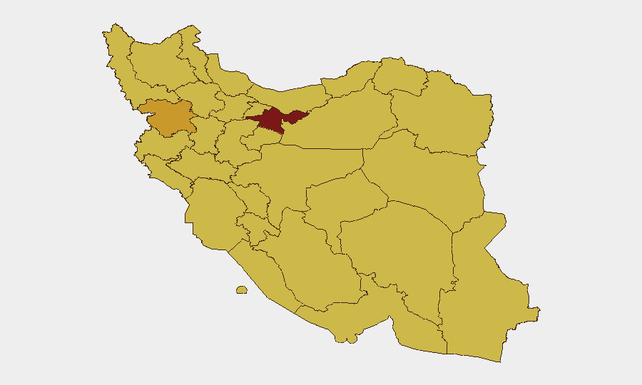
Situation Summary
Iran remains in a high-threat environment (composite risk 97, rank #6 globally) following sustained US strikes on military and infrastructure targets across multiple provinces during late July. Power disruptions, debris removal, and heightened military presence continue in major coastal and inland zones as of August 1–2, 2026. Regional tensions are amplified by Iranian announcements of a Strait of Hormuz closure and ongoing maritime incidents near the southern Gulf approaches. The security posture is characterized by visible military activity in urban centers, disrupted telecommunications, and active Iranian–US kinetic operations.
Key Developments
- Hormozgan Province (Qeshm Island, Bandar Abbas) – July 31–August 1: Continued power outages and emergency recovery operations reported following July 30 US strikes on IRGC coastal defense and missile sites; explosions and debris removal visible to residents and documented in local media posts through August 1.
- Khuzestan Province (Abadan) – July 31–August 1: Deputy security minister confirmed US strikes on "locations in Abadan"; heightened security posture and infrastructure recovery efforts remained active and cited in state broadcaster updates on August 1.
- Fars Province (Kazerun outskirts, Kish Island) – July 31–August 1: Tasnim agency reported US strikes on Kazerun and explosions on Kish Island; ongoing power and transport disruptions reported in regional security commentary through August 1.
- West Azerbaijan Province (near Piranshahr) – July 31: Iranian outlets reported US missile strike on uninhabited border area with no casualties; incident cited in ongoing regional military updates on July 31.
- National Security Posture – July 31–August 1: Al Jazeera reporting from Tehran notes streets "mostly tranquil" but internet connectivity remains disrupted and military presence is visible; residents practicing sheltering behavior. Canada's travel advisory (updated August 1) warns of drone, missile, and projectile strikes with potential for renewed military activity on short notice.
- Strait of Hormuz – August 1: Iran's Khatam al-Anbiya Central Headquarters announced closure of the Strait to maritime traffic, citing alleged ceasefire breaches; simultaneously, UKMTO reported a tanker hit by unidentified projectile near southern Strait approaches with engine damage but no casualties.
- Maritime Blockade Announcement – August 1: Iran's Supreme National Security Council secretary announced intent to reinforce blockade of Strait of Hormuz and stated Tehran will resist alleged US blockade of Iranian shipping routes, directly impacting access to southern Iranian ports.
Highest-Risk Areas
Tehran Province (97.6) remains the highest-risk zone, driven by its status as the political and administrative capital and concentration of government, military, and critical infrastructure targets. Kurdistan (72.4) and Isfahan (69.2) rank second and third, reflecting border proximity, ethnic tensions, and industrial/military facility concentration. Southwestern provinces—Khuzestan (68.8), Sistan and Baluchestan (68.3), and Hormozgan (67.7)—face compounded risk from recent direct strike activity, ongoing maritime security incidents, and critical Gulf infrastructure. The clustering of 68+ risk scores across the southern, southwestern, and northwestern provinces indicates sustained threat from external military activity, regional instability, and internal security operations.
How GeoBit Would Assist
Security teams would use AOI Monitoring & Early Warning to track persistent threats in high-risk provinces (particularly Hormozgan, Khuzestan, and Isfahan) with real-time alerting on resumed military activity or infrastructure disruption. Maritime & Aviation Tracking combined with Intel Sweep and OSINT fusion would monitor Strait of Hormuz shipping, tanker movements, and official Iranian announcements to anticipate supply-chain and travel disruptions. Conflict & Military force-structure and GIS & Spatial Analysis capabilities would help map active strike zones and safe routing for personnel and assets.
7-Day Outlook
Kinetic operations and infrastructure strain are likely to persist through early August; internet and power disruptions may remain intermittent in coastal and southwestern zones. Maritime risk will remain elevated if Iran's Strait closure announcement and announced blockade reinforcement proceed. A tactical lull is possible but geopolitical and military pressure suggests heightened volatility through mid-August.
Highest-Risk Areas — Ranked
| # | State / Region | Risk |
|---|---|---|
| 1 | Tehran Province | 97.6 |
| 2 | Kurdistan Province | 72.4 |
| 3 | Isfahan Province | 69.2 |
| 4 | Khuzestan Province | 68.8 |
| 5 | Sistan and Baluchestan Province | 68.3 |
| 6 | Alborz Province | 68.3 |
| 7 | Kermanshah Province | 68 |
| 8 | Bushehr Province | 67.7 |
| 9 | Hormozgan Province | 67.7 |
| 10 | North Khorasan Province | 67.6 |
| 11 | Razavi Khorasan | 67.6 |
| 12 | Ilam Province | 67.6 |
Sources
Previous Daily Briefs
A new Iran brief is written every day — each with its own risk map and downloadable CSV. Here's the last week; use the calendar to go further back.
📅 Browse every day by calendar →
Highlighted days have a brief. Tap a day for that day's map & analysis, or “csv” for that day's dataset ($5).
Atlas — our AI intelligence desk — emails them this snapshot personally. Nothing else, no list.