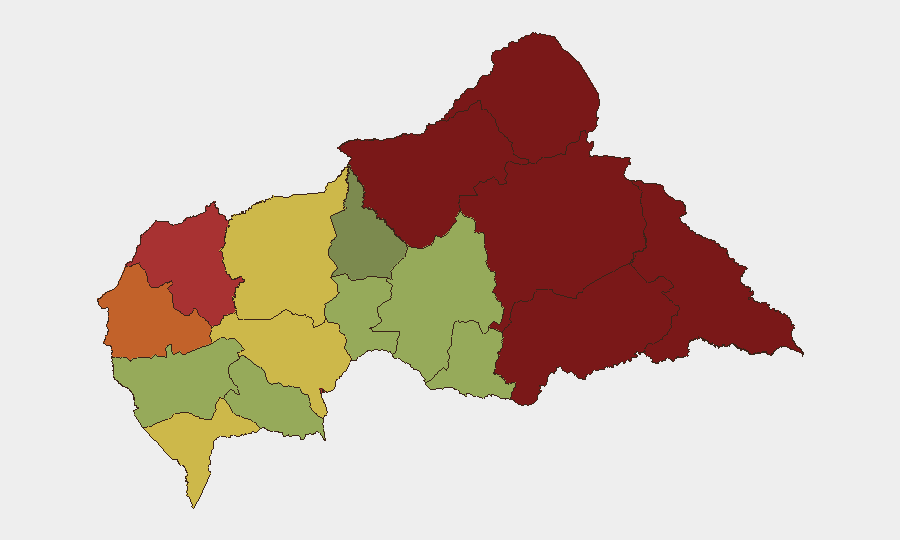
Situation Summary
Central African Republic remains in a state of chronic instability driven by armed group activity, cross-border incursion, and weak state control outside the capital. The composite national threat score of 65 ranks CAR #32 globally, with conflict and criminality as primary drivers. Over the past week, incidents have included abductions, armed attacks on civilians, cross-border security violations, and a major transport accident, indicating both persistent non-state armed actor (NSAA) presence and capacity gaps in border management and accident response. Risk is heavily concentrated in the eastern and northeastern prefectures, with Bangui itself remaining a secondary tier of concern.
Key Developments
- Bimbo (south of Bangui), 8 August 2026: A tanker carrying flammable liquids overturned on a main road, killing at least 8 people and injuring approximately 10 others. The incident highlights critical infrastructure and transport safety vulnerabilities in the capital region.
- Damara mining area (~50 km north of Bangui), 31 July / reported 7 August 2026: Swiss geologist Luca Maggini and a CAR military escort were abducted by unidentified armed men at a mining project. CAR authorities subsequently launched a criminal investigation and announced heightened security around UAE-operated mining sites in the area, signaling concern over asset protection and staff safety in the extractive sector.
- Cameroon–CAR border (Gasol village, 6 km from border), 1 August 2026: Two armed Cameroonian gendarmes were arrested by CAR authorities following alleged unauthorized armed incursion into CAR territory, reflecting ongoing cross-border security friction.
- Bilateral security coordination, 10 August 2026: Interior ministers of Cameroon and CAR held talks to address cross-border crime, irregular migration, and armed incursion—indicating official acknowledgment of transnational security challenges and potential for improved coordination.
- Eastern prefectures (Vakaga/Bamingui-Bangoran region), ongoing through early August 2026: Disarmament operations involving Russian military specialists and CAR forces have yielded weapon seizures and voluntary militia lay-downs (69 UPC militants in Malum village on 7 August), with some armed clashes; this reflects active stabilization efforts but also residual NSAA capacity in the highest-risk zones.
Highest-Risk Areas
The eastern and northeastern prefectures—Vakaga (risk 95), Bamingui-Bangoran (92), Haute-Kotto (88), and Haut-Mbomou (85)—drive the national threat score. These regions remain poorly governed, host multiple armed groups, and experience frequent inter-communal and NSAA-versus-state violence. Bangui itself (risk 78) carries significant urban crime and targeted attack risk, as illustrated by the Maggini abduction near the capital and the transport disaster in Bimbo. The middle tiers (Ouham-Pendé, Nana-Mambéré, Sangha-Mbaéré) reflect secondary criminal activity and NSAA presence but lower intensity than the eastern corridor.
How GeoBit Would Assist
Teams operating in or responsible for CAR should employ AOI Monitoring & Early Warning to track activity around mining sites, key transport routes, and border crossings in real time; Conflict & Military mapping and force-structure analysis to track disarmament progress and NSAA relocations; and Routing & Network Analysis to identify safer alternative transport corridors and assess incursion patterns. OSINT fusion (social media, local reporting, radio SIGINT) would provide early signals of emerging kidnap/abduction threats and criminal network activity.
7-Day Outlook
Disarmament operations are likely to continue in the northeast, with sporadic clashes and weapon seizures expected. Cross-border incursions and criminal activity will persist absent significant enforcement escalation. The transport/infrastructure accident underscores non-security risks to personnel and supply lines, particularly around Bangui and main road corridors.
Highest-Risk Areas — Ranked
| # | State / Region | Risk |
|---|---|---|
| 1 | Vakaga | 95 |
| 2 | Bamingui-Bangoran | 92 |
| 3 | Haute-Kotto | 88 |
| 4 | Haut-Mbomou | 85 |
| 5 | Mbomou | 82 |
| 6 | Ouham-Pendé | 79 |
| 7 | Bangui | 78 |
| 8 | Nana-Mambéré | 75 |
| 9 | Sangha-Mbaéré | 68 |
| 10 | Ouham | 65 |
| 11 | Ombella-M'Poko | 62 |
| 12 | Kémo | 58 |
Sources
Previous Daily Briefs
A new Central African Republic brief is written every day — each with its own risk map and downloadable CSV. Here's the last week; use the calendar to go further back.
- August 12, 2026
- August 11, 2026
- August 10, 2026
- August 9, 2026
- August 8, 2026
- August 7, 2026
- August 6, 2026
📅 Browse every day by calendar →
Highlighted days have a brief. Tap a day for that day's map & analysis, or “csv” for that day's dataset ($5).
Atlas — our AI intelligence desk — emails them this snapshot personally. Nothing else, no list.