Situation Summary
Central African Republic remains classified as a #33 global security concern (composite threat score 65), with armed-group activity, cross-border incursions, and localized violence as primary drivers. The security environment is regionally fragmented: the northern and eastern prefectures (Vakaga, Bamingui-Bangoran, Haute-Kotto) present acute conflict risk, while Bangui and surrounding areas face urban crime and spillover volatility. Recent disarmament operations and weapons interdictions suggest ongoing state and international counter-insurgency efforts, though militant activity persists in remote zones. No major incident has been reported in the last 24–48 hours; Independence Day observances on 14 August proceeded without documented security disruptions.
Key Developments
- Bangui – 14 August 2026 – Independence Day observance. CAR marked its 66th Independence Day with President Faustin-Archange Touadéra calling for national modernization reforms. Security deployments were in place; no significant security incident was reported during or immediately after the event.
- Northern prefectures – 3–8 August (recent operational window). Counter-insurgency operations, armed-group raids, and disarmament activities continue in Ouham, Vakaga, and nearby zones. On 8 August, 69 UPC ex-combatants voluntarily disarmed in Malum village; on 7 August, Russian specialists and CAR/UPC personnel identified a weapons cache (4 DShK units, 1 W87) in the Atongo-Bokari area. Small-cell motorcycle-mounted raids near Birao and Matala (early August) killed at least 5 civilians; perpetrators remain at large.
- Gasol, Cameroon border – 1 and 7 August (repeated incursions). Two Cameroonian gendarmes were arrested by CAR authorities following presumed cross-border incursions near Gasol village, approximately 6 km from the Cameroon border. Incidents on both 1 and 7 August suggest an active border-security concern.
- Vakaga Prefecture – 31 July (kidnapping ongoing). Swiss geologist Luca Maggini and his military security detail were abducted by unidentified armed men from a quarrying area in Vakaga. No public resolution or ransom claim has been reported as of 15 August.
- South of Bangui – 8 August (transport disaster). A tanker carrying flammable liquids overturned, killing at least 8 people and injuring 10 others. The incident was not security-related but underscores infrastructure fragility and emergency-response capacity constraints in key transport corridors.
Highest-Risk Areas
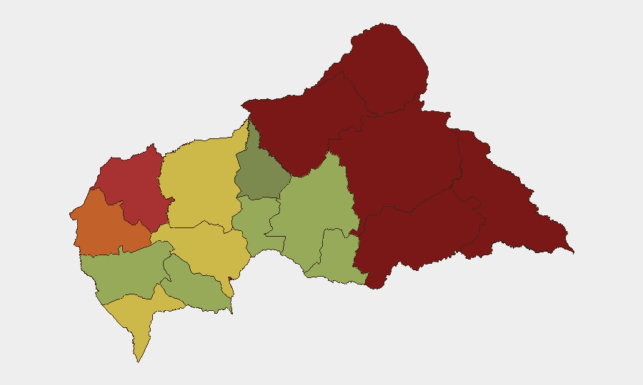
Vakaga (risk 95), Bamingui-Bangoran (92), and Haute-Kotto (88) dominate the sub-national risk profile, driven by sustained armed-group presence, raiding activity, and limited state capacity in remote northeastern zones. Bangui itself (risk 78) and surrounding Ombella-M'Poko (62) reflect urban crime, crowd risks, and proximity to armed actors. The eastern corridor (Haut-Mbomou, Mbomou, risk 85 and 82 respectively) remains volatile due to militia activity and porous borders with South Sudan and Democratic Republic of Congo. Organizations with personnel or assets in these areas should apply heightened protective measures and maintain real-time situational awareness.
How GeoBit Would Assist
Security teams should deploy AOI Monitoring & Early Warning on high-risk prefectures (Vakaga, Bamingui-Bangoran, Haute-Kotto) to detect emerging armed-group movement and raiding patterns. Conflict & Military analysis (force structure, weapons-capability tracking) would track disarmament progress and militant capability degradation. Routing & Network Analysis would identify secure transit corridors around Bangui and flag cross-border incursion hotspots for personnel movement planning.
7-Day Outlook
Armed-group activity in the north is likely to persist despite disarmament operations; motorcycle raids and kidnappings remain probable in remote prefectures. Bangui and national-level security are expected to remain stable in the near term, though urban crime and criminal activity are endemic. Border tensions with Cameroon warrant close monitoring.
Highest-Risk Areas — Ranked
| # | State / Region | Risk |
|---|---|---|
| 1 | Vakaga | 95 |
| 2 | Bamingui-Bangoran | 92 |
| 3 | Haute-Kotto | 88 |
| 4 | Haut-Mbomou | 85 |
| 5 | Mbomou | 82 |
| 6 | Ouham-Pendé | 79 |
| 7 | Bangui | 78 |
| 8 | Nana-Mambéré | 75 |
| 9 | Sangha-Mbaéré | 68 |
| 10 | Ouham | 65 |
| 11 | Ombella-M'Poko | 62 |
| 12 | Kémo | 58 |
Sources
Previous Daily Briefs
A new Central African Republic brief is written every day — each with its own risk map and downloadable CSV. Here's the last week; use the calendar to go further back.
- August 14, 2026
- August 13, 2026
- August 12, 2026
- August 11, 2026
- August 10, 2026
- August 9, 2026
- August 8, 2026
📅 Browse every day by calendar →
Highlighted days have a brief. Tap a day for that day's map & analysis, or “csv” for that day's dataset ($5).
Atlas — our AI intelligence desk — emails them this snapshot personally. Nothing else, no list.