Situation Summary
Central African Republic remains a fragile, conflict-affected state with a composite threat score of 65, ranking #33 globally. Armed group activity, intercommunal tensions, and weak state capacity continue to drive insecurity across much of the country, particularly in the northeast and eastern border zones. Recent operations by joint Russian-CAR security forces indicate active counter-insurgency efforts, though humanitarian and occupational hazards—exemplified by a fatal mine collapse on 18 August—pose immediate risks to personnel independent of armed conflict.
Key Developments
- Abba, Nana-Mambéré (18 August 2026): Artisanal gold mine collapse killed at least 30 miners; ongoing recovery operations continue to strain local medical and emergency-response capacity, affecting area accessibility and duty-of-care obligations for organizations with staff or supply chains in western CAR.
- Yango–Gali area (17–18 August 2026): Joint Russian–CAR security forces reported armed clash with militants, resulting in at least two militants killed during a patrol; incident reflects persistent armed group presence and heightened risk of road clashes in the corridor.
- Buar area (17–18 August 2026): Joint forces reported discovery and destruction of a temporary militant camp and seizure of military property; indicates active armed group operations and security-force presence in central-northern CAR.
- Gordil area, Vakaga region (17–18 August 2026): Joint forces seized two machine guns and ammunition during search operations; reflects ongoing arms circulation and counter-insurgency activity in CAR's highest-risk prefecture.
- Bangui (18 August 2026): Judicial hearing implicated former president François Bozizé in disappearance of a political opponent; while non-violent, this sensitive political-judicial development carries potential to influence elite tensions and protest dynamics in the capital.
Highest-Risk Areas
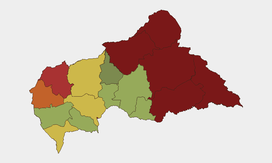
Vakaga, Bamingui-Bangoran, and Haute-Kotto prefectures drive the country's risk profile (scores 95, 92, and 88 respectively), reflecting active armed group presence, weak state control, and proximity to porous borders with Chad and Sudan. The eastern corridor—including Haut-Mbomou, Mbomou, and Ouham-Pendé—remains volatile, with ongoing security operations and trafficking of arms and combatants. Bangui itself (risk 78) faces lower but sustained risk from political tensions, crime, and occasional intercommunal violence; the capital remains the primary hub for international operations and thus a focus for situational awareness and contingency planning.
How GeoBit Would Assist
Security and risk teams should deploy AOI Monitoring & Early Warning on highest-risk prefectures (Vakaga, Bamingui-Bangoran, Haute-Kotto) to track armed group movements, checkpoints, and operational patterns; pair this with Intel Sweep and multi-language OSINT to detect emerging clashes, displacement, or closure of key supply routes. Routing & Network Analysis enables real-time alternative-route planning for staff and supply convoys, especially through volatile eastern and northeastern zones. Satellite & Imagery analysis and GIS & Spatial Analysis support damage assessment and operational-zone mapping following incidents like the Abba mine collapse, informing evacuation and medical-evacuation protocols.
7-Day Outlook
Near-term stability appears likely in the absence of major new clashes or political upheaval, though low-intensity armed group activity and security-force operations will persist in the northeast and east. The Abba mine collapse and ongoing recovery operations will occupy local resources and media attention for several days; international organizations and private operators should anticipate disrupted local-authority responsiveness and road congestion in Nana-Mambéré. Risk of secondary incidents (mine closures, personnel displacement, protests over safety) in artisanal mining zones warrants close monitoring.
Highest-Risk Areas — Ranked
| # | State / Region | Risk |
|---|---|---|
| 1 | Vakaga | 95 |
| 2 | Bamingui-Bangoran | 92 |
| 3 | Haute-Kotto | 88 |
| 4 | Haut-Mbomou | 85 |
| 5 | Mbomou | 82 |
| 6 | Ouham-Pendé | 79 |
| 7 | Bangui | 78 |
| 8 | Nana-Mambéré | 75 |
| 9 | Sangha-Mbaéré | 68 |
| 10 | Ouham | 65 |
| 11 | Ombella-M'Poko | 62 |
| 12 | Kémo | 58 |
Sources
Previous Daily Briefs
A new Central African Republic brief is written every day — each with its own risk map and downloadable CSV. Here's the last week; use the calendar to go further back.
- August 18, 2026
- August 17, 2026
- August 16, 2026
- August 15, 2026
- August 14, 2026
- August 13, 2026
- August 12, 2026
📅 Browse every day by calendar →
Highlighted days have a brief. Tap a day for that day's map & analysis, or “csv” for that day's dataset ($5).
Atlas — our AI intelligence desk — emails them this snapshot personally. Nothing else, no list.