Situation Summary
Central African Republic remains at composite threat level 65 (rank #33 globally), with conflict and armed group activity concentrated in the northeastern and eastern prefectures. A major industrial disaster on 18 August—a catastrophic artisanal gold mine collapse in Nana-Mambéré prefecture near the Cameroon border—has become the dominant security and safety incident of the past 48 hours, with over 100 confirmed or suspected fatalities. Concurrent Russian-CAR joint security operations in northern areas (Vakaga, Bamingui-Bangoran) continue to report militant contact and weapons seizures, indicating sustained counter-insurgency pressure. The threat profile remains driven primarily by armed group activity in remote zones and now by acute occupational/infrastructure hazard in the western mining corridor.
Key Developments
- Zamboye/Abba artisanal gold mine collapse, Nana-Mambéré Prefecture, 18 August 2026 (morning): A major landslide buried miners in underground tunnels; initial recovery reported at least 30 bodies, with later estimates exceeding 100 fatalities including at least four Cameroonian nationals. Search and rescue operations were ongoing as of 19–20 August. Judicial inquiry announced into site conditions and operator oversight.
- Cross-border impact, Zamboye mining zone, 18–19 August 2026: Cameroon authorities confirmed readiness to receive and treat injured miners fleeing across the border; incident has disrupted artisanal mining activity in the western CAR–Cameroon corridor and elevated occupational-safety risk for any personnel in or near mining areas.
- Social media corroboration, 18–19 August 2026: Video footage circulating on X/Twitter and regional outlets confirmed a wave of earth and sand descending on the mining site, with opposition figures citing the collapse as evidence of unsafe artisanal mining practices and lack of formal regulatory oversight in border regions.
- Russian-CAR security operations, Gordil and Yango-Gali areas (northern CAR), prior to 17 August (reported 17–18 August): Joint patrols encountered armed militants; two militants killed in the Yango-Gali clash, and 2 machine guns plus ammunition seized in Gordil area. These operations pre-date the 24–48-hour window but reflect elevated counter-insurgency activity in Vakaga and Bamingui-Bangoran prefectures.
- Judicial and humanitarian response, national level, 19–20 August 2026: Prosecutors initiated formal inquiry into gold mine collapse; Baboua hospital received injured evacuees. No indication of security-force obstruction to rescue operations or border transit for medical evacuation.
Highest-Risk Areas
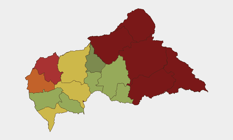
Vakaga, Bamingui-Bangoran, and Haute-Kotto prefectures (north and northeast, risk scores 95, 92, and 88 respectively) remain the geographic priority for conflict-related risk, driven by armed group presence and ongoing Russian-CAR counter-insurgency operations. Bangui (risk 78) carries persistent urban security concerns related to criminal activity and protest risk. Nana-Mambéré prefecture (risk 75, western border zone) has now emerged as a critical acute hazard zone due to the artisanal mining collapse, with implications for road transit, cross-border movement, and occupational safety in the Baboua corridor. Personnel or supply chains transiting the western prefectures should anticipate disruption and heightened humanitarian-access demands.
How GeoBit Would Assist
Security teams should employ AOI Monitoring & Early Warning to maintain persistent watch on Vakaga, Bamingui-Bangoran, and the Nana-Mambéré border corridor for renewed militant activity or mining-related incidents. Routing & Network Analysis capabilities can identify safe alternative routes around the Baboua mining zone and assess cross-border transit windows. Conflict & Military mapping combined with OSINT fusion (X/Twitter, local media, and humanitarian feeds) will track Russian-CAR operation tempo and armed group movement to enable real-time duty-of-care updates for personnel in northern regions.
7-Day Outlook
The mining disaster will likely drive humanitarian and investigative activity in the western border zone through late August, potentially complicating civilian movement and logistics for 5–10 days. Northern counter-insurgency operations are expected to continue at current intensity, with search-and-seizure activity dominant in Vakaga and surrounding areas. No imminent nationwide escalation is signaled; risk remains geographically compartmented.
Highest-Risk Areas — Ranked
| # | State / Region | Risk |
|---|---|---|
| 1 | Vakaga | 95 |
| 2 | Bamingui-Bangoran | 92 |
| 3 | Haute-Kotto | 88 |
| 4 | Haut-Mbomou | 85 |
| 5 | Mbomou | 82 |
| 6 | Ouham-Pendé | 79 |
| 7 | Bangui | 78 |
| 8 | Nana-Mambéré | 75 |
| 9 | Sangha-Mbaéré | 68 |
| 10 | Ouham | 65 |
| 11 | Ombella-M'Poko | 62 |
| 12 | Kémo | 58 |
Sources
Previous Daily Briefs
A new Central African Republic brief is written every day — each with its own risk map and downloadable CSV. Here's the last week; use the calendar to go further back.
- August 19, 2026
- August 18, 2026
- August 17, 2026
- August 16, 2026
- August 15, 2026
- August 14, 2026
- August 13, 2026
📅 Browse every day by calendar →
Highlighted days have a brief. Tap a day for that day's map & analysis, or “csv” for that day's dataset ($5).
Atlas — our AI intelligence desk — emails them this snapshot personally. Nothing else, no list.