Situation Summary
Central African Republic remains a high-risk operating environment (global rank #33, composite threat score 65) driven primarily by persistent armed conflict and state fragility. The country's security landscape is dominated by competition for resources, weak institutional control in the periphery, and the presence of Russian security contractors alongside CAR government forces. As of 21 August 2026, the dominant security event is a mass-casualty industrial disaster rather than acute armed conflict, though structural instability in resource-extraction zones and border areas continues to present significant risk to personnel and operations.
Key Developments
- Zamboye artisanal gold mine collapse, Nana-Mambéré prefecture (CAR–Cameroon border), 18 August 2026. An unregulated gold pit near Zamboye village collapsed around 14:00 local time, killing at least 49 miners officially reported by the CAR mines minister (34 Central Africans, 13 Cameroonians, 2 Chadians), though regional Cameroonian authorities and international media cite tolls exceeding 100 dead with additional miners unaccounted for.
- Government closure and security deployment, Zamboye site, 20 August 2026. CAR mines minister Rufin Benam-Beltoungou announced temporary closure of the Zamboye pit following his site visit. Russian security elements were deployed to control access; rescue operations were suspended due to ongoing ground instability and flooding in the mine shaft.
- Medical surge response, Baboua hospital, Nana-Mambéré prefecture, 18–20 August 2026. At least seven critically injured survivors were evacuated from the collapse site to Baboua town (~50 km away), straining local hospital capacity and triggering investigation by the Baboua sub-prefecture court into operational liability.
- Casualty figure discrepancies and information environment fragmentation, 19–21 August 2026. Official CAR count (49) significantly diverges from regional Cameroonian and international media reports (100+). Video and imagery of the collapse circulated widely on social media and international news outlets, emphasizing structural risks in informal mining and triggering international expressions of solidarity (including UAE foreign ministry messaging).
- Cross-border mining enforcement implications, western CAR, ongoing. The closure and announced tightening of informal-mining oversight signal potential friction with local artisanal operators and armed actors deriving revenue from resource sites, particularly in remote border zones where state enforcement capacity is limited.
Highest-Risk Areas
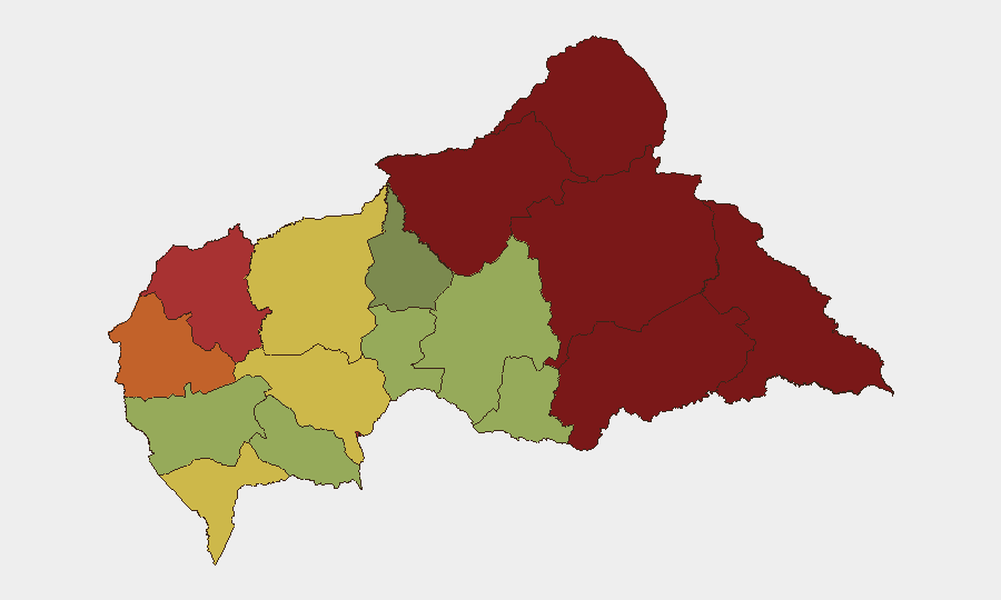
Vakaga (95), Bamingui-Bangoran (92), and Haute-Kotto (88) prefectures drive the highest composite threat scores, reflecting entrenched armed-group presence, minimal government control, and resource competition in the northeast and north-central zones. Bangui (78) remains elevated due to state-capital volatility and mixed-actor control. The recent Zamboye disaster underscores secondary risk in Nana-Mambéré (75) and border zones: artisanal resource extraction attracts unregulated labor pools, informal armed actors, and cross-border criminal networks, creating humanitarian and security cascades when infrastructure fails.
How GeoBit Would Assist
Security teams operating in Central African Republic should deploy AOI Monitoring & Early Warning on high-risk prefectures (Vakaga, Bangui, border mining zones) for alerts on armed movement, resource-site incidents, or forced displacement. OSINT fusion & corroboration and multi-language search are essential for disambiguating conflicting casualty and incident reports in low-transparency environments. Routing & Network Analysis capabilities support safe corridor planning in areas where armed actors and informal enforcement structures create unpredictable access constraints.
7-Day Outlook
The Zamboye closure and security deployment are likely to remain in effect for at least one week pending structural assessment and further recovery operations. The casualty toll discrepancy may persist, complicating humanitarian response coordination. Monitor for secondary effects: local miner displacement, potential armed-actor revenue loss in border zones, and cross-border tensions if Cameroon escalates demands for joint investigation or reparations.
Highest-Risk Areas — Ranked
| # | State / Region | Risk |
|---|---|---|
| 1 | Vakaga | 95 |
| 2 | Bamingui-Bangoran | 92 |
| 3 | Haute-Kotto | 88 |
| 4 | Haut-Mbomou | 85 |
| 5 | Mbomou | 82 |
| 6 | Ouham-Pendé | 79 |
| 7 | Bangui | 78 |
| 8 | Nana-Mambéré | 75 |
| 9 | Sangha-Mbaéré | 68 |
| 10 | Ouham | 65 |
| 11 | Ombella-M'Poko | 62 |
| 12 | Kémo | 58 |
Sources
Previous Daily Briefs
A new Central African Republic brief is written every day — each with its own risk map and downloadable CSV. Here's the last week; use the calendar to go further back.
- August 20, 2026
- August 19, 2026
- August 18, 2026
- August 17, 2026
- August 16, 2026
- August 15, 2026
- August 14, 2026
📅 Browse every day by calendar →
Highlighted days have a brief. Tap a day for that day's map & analysis, or “csv” for that day's dataset ($5).
Atlas — our AI intelligence desk — emails them this snapshot personally. Nothing else, no list.