Situation Summary
Central African Republic remains a high-risk operating environment (global ranking #33, composite threat score 65) driven primarily by active armed conflict and weak state capacity. The country's security landscape is heavily concentrated in the northeast and eastern frontier zones, where armed group activity, banditry, and state fragility create compounding risks. A major industrial disaster at an artisanal gold mine near the Cameroon border has added acute humanitarian and infrastructure strain to the existing threat picture, with ongoing casualty recovery and site-security operations dominating the near-term risk environment.
Key Developments
- Zamboye artisanal mine collapse – 2026-08-22: Casualty estimates have been revised upward to exceed 100 deaths, with local officials and media reporting ongoing body recovery and identification of missing miners. The 2026-08-18 incident remains active as a mass-casualty event.
- Zamboye site stability – 2026-08-22: Authorities confirmed rescue operations remain underway in an unstable pit environment, with reports of continued collapses and flooding in lower sections. The site is unsuitable for immediate re-entry or civilian access.
- Medical evacuation corridor – 2026-08-22: Injured miners are being transported approximately 50 km westward to Baboua for treatment, with cross-border medical coordination from Cameroon. This has created surge demand on roads and local health infrastructure in the Baboua–Zamboye corridor.
- Mine closure and access control – 2026-08-22: The CAR government has formally suspended and barred access to the Zamboye pit "until further notice." Enforcement and compliance among informal operators remain uncertain.
- Security deployment at site – 2026-08-22: Armed security personnel, including reportedly Russian paramilitary/Wagner-linked contingents, have been deployed to secure the mine perimeter and control access during the suspension. Risk of friction with local communities or informal miners persists.
- International media attention – 2026-08-22: Video documentation of the landslide and casualty scale has circulated through international outlets, potentially prompting renewed regulatory scrutiny or ad hoc enforcement actions at other artisanal mining sites across CAR.
- Humanitarian operating environment – 2026-08-22 (aggregate through 20 Aug): A newly publicized report indicates 64 security incidents affecting humanitarian workers since January 2026, including armed robberies, looting, assaults, and intimidation. This reflects persistent organized crime and threat-actor targeting of NGO and aid operations.
Highest-Risk Areas
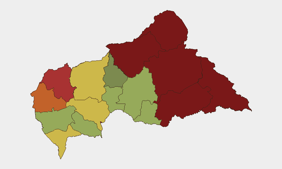
Vakaga, Bamingui-Bangoran, and Haute-Kotto provinces in the northeast drive the overall country risk ranking, each scoring above 88 and reflecting active armed-group presence, banditry, and minimal state control. The eastern frontier (Haut-Mbomou, Mbomou) sustains high scores due to cross-border instability and informal economy vulnerabilities. Bangui (risk 78) remains a significant concern despite lower ranking, given its status as the capital and hub for humanitarian, diplomatic, and commercial activity; security incidents, crime, and infrastructure fragility affect all international operations. The Zamboye incident, though located in a lower-ranked peripheral zone, underscores how localized industrial disasters can spike risk for any personnel or supply chains dependent on artisanal-sector employment or trade corridors.
How GeoBit Would Assist
Teams should deploy AOI Monitoring & Early Warning on Zamboye and the broader Baboua–Cameroon border corridor to track rescue operations, security deployments, and casualty updates in real time. OSINT Fusion & Corroboration (including X/Twitter, Telegram, and YouTube intelligence) will capture ground-level reports from miners, local media, and security actors faster than official channels. Routing & Network Analysis can identify safe alternative transport corridors for staff or supply movement during emergency-response congestion and ongoing instability.
7-Day Outlook
The Zamboye casualty recovery and site stabilization will remain active for the next week, with continued ambulance traffic, security presence, and international media focus. Enforcement of the mine closure may encounter resistance from informal operators facing job loss; secondary incidents (theft, confrontation with security) are possible. No significant shift in broader armed-group activity or conflict intensity is expected in the near term, though humanitarian access disruption and road congestion in western CAR should be anticipated for operations spanning Baboua or the Cameroon border.
Highest-Risk Areas — Ranked
| # | State / Region | Risk |
|---|---|---|
| 1 | Vakaga | 95 |
| 2 | Bamingui-Bangoran | 92 |
| 3 | Haute-Kotto | 88 |
| 4 | Haut-Mbomou | 85 |
| 5 | Mbomou | 82 |
| 6 | Ouham-Pendé | 79 |
| 7 | Bangui | 78 |
| 8 | Nana-Mambéré | 75 |
| 9 | Sangha-Mbaéré | 68 |
| 10 | Ouham | 65 |
| 11 | Ombella-M'Poko | 62 |
| 12 | Kémo | 58 |
Sources
Previous Daily Briefs
A new Central African Republic brief is written every day — each with its own risk map and downloadable CSV. Here's the last week; use the calendar to go further back.
- August 21, 2026
- August 20, 2026
- August 19, 2026
- August 18, 2026
- August 17, 2026
- August 16, 2026
- August 15, 2026
📅 Browse every day by calendar →
Highlighted days have a brief. Tap a day for that day's map & analysis, or “csv” for that day's dataset ($5).
Atlas — our AI intelligence desk — emails them this snapshot personally. Nothing else, no list.